|
|
|
 |
|
|
|
|
|
This web site is unfortunately no longer updated
because I have turned toward other adventures.
However, I still have many visitors, many
people who ask me their questions, tell me
their stories or ask me for a the newsletter
that is no longer published .... To all these
strangers, I mean this:
This web site born before the web 2.0, before
the social networks and shows what was a bit
the prehistory of the HTML web. However, it
took me 6 years of hard work, a lot of work
wait be online, so much more to tell ... Blankonthemap
is still there for as long as our browsers
can read HTML, it is like an isolated mountain
inviting us to enter the marvelous world of
Karakoram.
Bruno Collard
© Blankonthemap
- Septembre 2017
|
|
 |
|
|
|
Blankonthemap
INFO N°52
14th october 2013
|
Envolées
belles
A story of bivouac flight
A
major book on the bivouac flight told by
regretted Philippe Nodet and retranscribed
by his wife from her personal notes.
Exclusive
interview of Mariette Nodet for Blankonthemap!
|
|
Where common peoples marking with their
steps and baptizing of their names mountains
summits, Philippe overflew it without arrogance
and with the healthy and simple desire of
pondering. Because the obvious fact knocks
in the reading of this book. On more than
a read page I said to myself " but so
why the climbers do not think of stealing,
at least to spot their objectives closer and
avoid the traps ?! " This book is a real
call to the passion, to the freedom, to the
beauty.
Mariette Nodet pleases us to speak to us
about this exceptional book.
[Blankonthemap] Mariette, can you tell
us about your book?
[Mariette Nodet] " My " book?
I worked four years on this project and I
have not been able to put my name on the cover
! Just because it's not my book, but the Philippes
book dreamed of writing. I am committed to
not add anything to the material he had left
behind him books flights kid , travel books
, articles and interviews. The task was to
select , assemble, truncate if necessary,
to highlight or echo, to be a book that you
would not want to leave .
4 years to make it sure looks long, actually
I worked in fits and starts , in addition
to my work, my travels and my daily survival
. There has been long periods of latency ,
and other periods of intense work. The hardest
part is to work alone, and at the same time
this is what I needed. Finally, the initial
project was to collect the writings of his
father, Lou, this has resulted in a real book
on the flight camp that may be of interest
as the mountain , the traveler as impassionate
by Himalayas and more . That's what was important
to me : I wanted anything but a memory book
tearful , but a hymn to live fully ! In this
sense , it is "his" book !
[BOTM] Why this book? I insist
[MN] The realization of this book
was a necessity even if I did not know what
form it would lead. Initially, books discovered
in the business of Philippe have plunged me
into his world, the bivouac flight. I was
in the hands of far more valuable than just
writing stories or thoughts because they revealed
deeper quest that has always animated Philippe:
freedom, commitment, nature related to a search
for spirituality. They echoed, but more raw
and real, all the articles that had been written
before. So I decided to use these writings
to form a testimony.
This realization was to me justified by the
fact that Philip had planned to write a book
on the bivouac flight . At the time of his
accident, he was currently working on the
foundations of a book with a publishing house
. So even though Wings beautiful has nothing
to do with the book allegedly written by Philip,
I have also in me this deep joy to have realized
this project close to his heart.
[BOTM] I quote the chapter naturally
captivated me, the chapter "the geographer
Happiness": "For me, three kinds
of roaming complement the bivouac flight.
One aesthetic, ideal road connecting the summits.
The other imaginary from my readings. And
a last upper air. My tools? Approximate maps,
Google earth. I track my routes, taking into
account above all the laws of the upper air,
and stress relief. But, especially for the
Karakoram, they also faithfully follow the
thread of my imagination fed stories Wilfried
Thesiger, Eric Shipton, Bill Tilman, spies
Great Game, to climbers Mummery, Herman Buhl
or Messner. " Thanks to the bivouacs
flight,
Philippe was it one of the last true explorers
in this over and disenchanted world?
[MN] I don't think we can say it was
one of the last true explorers, it would not
be presumptuous? Because exploration is always
reinventing and luckily he is constantly inflamed
to delight us again. But it is true that he
had a major asset, like all those who practice
flight bivouac, one can use an absolutely
extraordinary exploration tool: paragliding.
Its lightness and simplicity allowed can address
very remote areas, without being too shift
towards local populations. The glider also
implies a state of openness, acceptance, it
allows for experiences that we could not live
in moving otherwise. Philip had more donation
to marry his love of reading, geography and
flight.
[BOTM] Presumptuous ? I can not
help but think of the great explorers by reading
this passage: " The view is literally
stunning. We are exactly at the vertical confluence
of the most fantastic three mountain ranges
in the world, Karakoram , Hindu Kush and Pamir
. And while I wind thermals closer to sailing
Julien , suddenly I measure my situation to
the exact culmination of my passion for adventure.
We just live in the most beautiful flight
of our lives.
After the last full vertical Khoz Sar (6800m)
, we switch to a Tolkien world, a giant ice
castle with a multitude of breathtaking walls
, completely frozen. The transition is carefree,
and now we 're off for a long session slide
in vertical glacier Yacund with already in
sight of the mountains red blood Valley Chapursan
. We managed to cross the Batura ! The emotion
is the extent of the landscape , fatigue too,
and I do not see that my speed / ground speeds
frankly me closer to the bottom of the valley.
A strong katabatic wind rushes into effect
of this huge ice mass. ". Shipton
Tillman Thesiger and others have never seen
this part of the world as Phillipe , I think
the north side of Khoz Sar in particular,
totally unknown as too far away from view.
In the Karakoram , besides the fact that many
areas of mass remain to be discovered , we
would probably do some amazing discoveries
like these curious aerological corridors including
Philippe speaks, winds style jet streams or
ancestries of staggering 150m upspeeds/ minute
only this range can offer. Philip was one
of the first pioneer of this exploration there,
isn't it?
[MN] In fact, the exploration livings
him completely. I remember the entire evening
immersed in the old stories of pionners, those
hours on the Internet to connect past and
future... and especially the time he spent
endless then to share my discoveries and enthusiasm
for the next voyage of discovery ! It was
tiring, that he was often so excited he could
not help but walk by talking , but fortunately
our room was tiny and it was soon the turn!
In short, a hyperactive illuminated at times
! This enthusiasm is finally easy to understand
when you know that he traveled areas are geographically
still very little known. And there's something
incredible to say the twenty-first century
conceals a multitude of mysteries to break
something . It is true that in any case there
weather in Karakoram and the Himalayas in
general, is unknown. I really wish someone
takes this exploration !
[BOTM] Philippe explored the remote Asia
to the mountains with his paraglider, I think
by the daring voyage he made the Hindu Raj
range in the south steeper slope. He could
baptize by his name as wind corridor, or as
we call heat as a top or a high pass, with
the difference that it is probably easiest
to set a name on a mountain on which it made
its mark on an element invisible and unpredictable
isn't it?
[MN] You're right, what's more ephemeral
than the elements of the thin air! And basically,
I think that Philippe gave these elements perfectly:
he would never have imagined baptize any place
if he was unknown, it was not his state of
mind. The only thing that mattered was the
pleasure, joy to excel and learn. I really
believe that he had nothing to prove to anyone,
or only things to himself, so intimate that
I never shared them (so intimate that they
were probably unconscious).
 Philippe, Himalayas in background
 |
[BOTM] Mariette, and you? You mention
in the book projects to follow the Philip
footsteps in the Northern Pakistan. What's
up?
[MN] I do not say it is in the
footsteps of Philippe I plan this trip north
Pakistan. I hope to be honest when I say I
do not go in his footsteps, even if it is
obvious that I would not set foot in this
place without him. Philippe had fallen so
in love with this region and its people, he
shared so much enthusiasm that we are bound
to feel gradually "from there",
beyond the fears of the unknown (including
related what the media describe the political
or religious as a country on the spot) . In
2010, we went with Lou in Afghanistan. You
can call me crazy, but I would say it was
an amazing trip, one that I certainly stronger
in my short history of traveler. The target
area was the Wakhan corridor, mythical and
beautiful across the country, and we were
accompanied by Dario January Alam, the Pakistani
friend of Philippe, very well connected to
Wakhis and Kyrgyz language that inhabit this
mountain land . Despite your determination,
you go with the ball in the stomach must admit
(especially with respect to Lou , who was
6 years old ) , and then you let yourself
be transformed by everything that happens
to you, the beauty and simplicity of things
especially . It is only in this kind of country
you can experience things like this, where
you can really let you shape. Then go north
Pakistan, just across the corridor, it's a
bit the same logic to this approach : it is
continue to allow feeding by the improbable.
It is also found Alam Jan , the landscape
of the Karakoram, not exploit, just short
long as this is the only way to fully experience
this kind of experience. I just need the energy
to do it , and people who believe in me to
get there... I know it will happen soon!
Par Philippe et Mariette Nodet.
160 pages with pictures.
15 euros + 4 euros for post stamps.
On sale now via the button below. If you
want to sell the book, do not hesitate to
contact us. Free shipping for purchases over
10 books.
|
© Blankonthemap
- octobre 2013
|
|
|
|
|
|
|
|
|
|
Blankonthemap
INFO N°51
25 juin 2013
|
Massacre
in paradise
11
climbers have died on the
Nanga Parbat base camp Diamir side.
|
There are news that give a bad taste in
the mouth. From memory, this is the first
time we attacked the tourists in the area.
11 climbers killed by a bullet in the head,
it's serious.
After all the events that Pakistan has relied
in recent years, I thought the region would
be destabilized earlier, in 2007, for example,
after the Red Mosque assault, when the Taliban
were trying to led Sharia laws in the Swat
valley and landed in Islamabad doors. The
Swat Valley is just near to the Indus, or
the valley remained neutral. We also know
that this is where Pakistani commandos join
the line of Indo-Pakistani front where it
heats occasionally.
it is therefore spent on the CB of Nanga
Parbat, west side (Diamir), I have personal
memories of a bad trip with armed pakis that
control the access road and did not hesitate
to play with their toys ... I'm sure it's
just a creepy story of a misunderstanding,
non-payment of a bakchich. All tourists like
guns shops in the Kohistan villages as Chilas.
Recall that bin Laden himself was hiding in
Abbotabbad, a town on the KKH with probable
bodyguards organized and dissuasive. The situation
is also part of a worrying escalationas the
murder of 20 innocent people in a bus on the
side of Babusar pass last year. Of course,
nothing to do with what happens further north
in Hunza for example, but I remember a Canadian
couple on their way to Kunjerab arrested between
Passu Karimabad and in their personal and
threatened by a dead car group had finally
fled without reason.
The cause is claimed to have achieved an
international echo, see if it will be fun....
Personally I am not optimistic for the future.
The season is probably already fucking and
perhaps for years. The scope of the drama
will be probably immeasurable, first for local
people.
Thinking of all those we love in this marvelous
part of the world.
|
© Blankonthemap
- juin 2013
|
|
|
|
|
|
|
|
|
|
Blankonthemap
INFO N°50
may 8 th2013
|
New
war on Depsang plateau?
|
It is a piece of news gone unnoticed in
France but of a big importance as regards
the fragile regional balances around the
Himalayan territories. China made in April
a 19 km raid on the Depsang plateau near
the famous Karakoram pass what could be
similar to an annexation since Kargil in
1999.
Although modest, this raid stop discussions
about the border disputes between India
and China which seemed nevertheless left
well. The Indian diplomacy is underway.
At this moment, China plays the reassurance
but denies raid on a Chinese territory (to
her). The technique is ground well and it
is likely that China camps obstinately over
its new positions.
These events bring to light the border
disputes Indo-Sino-Pakistanais of a rare
complexity which the difficult topography
of Himalaya and Karakoram does not have
allowed at the appropriate time to solve.
The situation is to be closely followed
because let us not forget that it is on
the same tray(plateau) of Depsang that India
was humbled by giving up(by selling) its
major part in 1962. it's is allowed to think
that India still bruised by this war shines
do not leave in front of this new affront.
©
Blankonthemap - mai 2013
|
|
|
|
|
|
|
|
|
|
|
Blankonthemap
INFO N°49
October 9 th 2012
|
Pamir,
forgotten on the roof of the world

La Martiniere editions recently published
a marvelous book . Photographer Matthieu
Paley and his wife Mareile Paley accompanied
by anthropologist Ted Callahan take us on
their enthusiastic story for over 10 years
on this little end of the world: the little
Pamir.

The story of the three is operated, punctuated
by some judicious cropping historical and
cultural richness of great value for the
history of this region, like those of Kyrgyz
people buffeted by geopolitical complex
circumstances. This is precisely what makes
this book exciting. The balance between
narrative of exalted adventurers and thousand
questions this story raises about the culture
and history of these people on their bums
plateau is well conducted. The story is
also punctuated by quotes as an homage to
Erik Shipton, Hedin, Wood ... to have humility
and honesty that others in past passed by
this area is quite rare and makes this book
highly respectable.
But this is not a book for science or for
historians, it is an adventure book and
pictures. Matthieu's pictures are wonderful.
With the beauty of the book very pleasant
to touch on a soft print pleasant for eyes,
the book is a very accomplished work both
in substance and in form.
Ultimately this is a huge job, Matt hat,
Mareile and Ted!
Forgotten on the roof
of the World - Afghanistan's Pamir mountains
- all images ©Matthieu Paley
from Matthieu
Paley.

©
Blankonthemap - Oct. 2012
|
|
|
|
|
|
|
|
|
|
|
Blankonthemap
INFO N°48
1 Oct. 2012
|
A
wonderfull flight around K2
©
Blankonthemap - Oct. 2012
|
|
|
|
|
|
|
|
|
|
|
Blankonthemap
INFO N°47
15 th june 2011
|
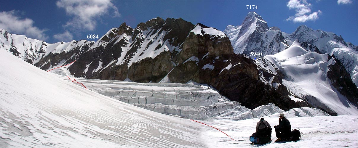
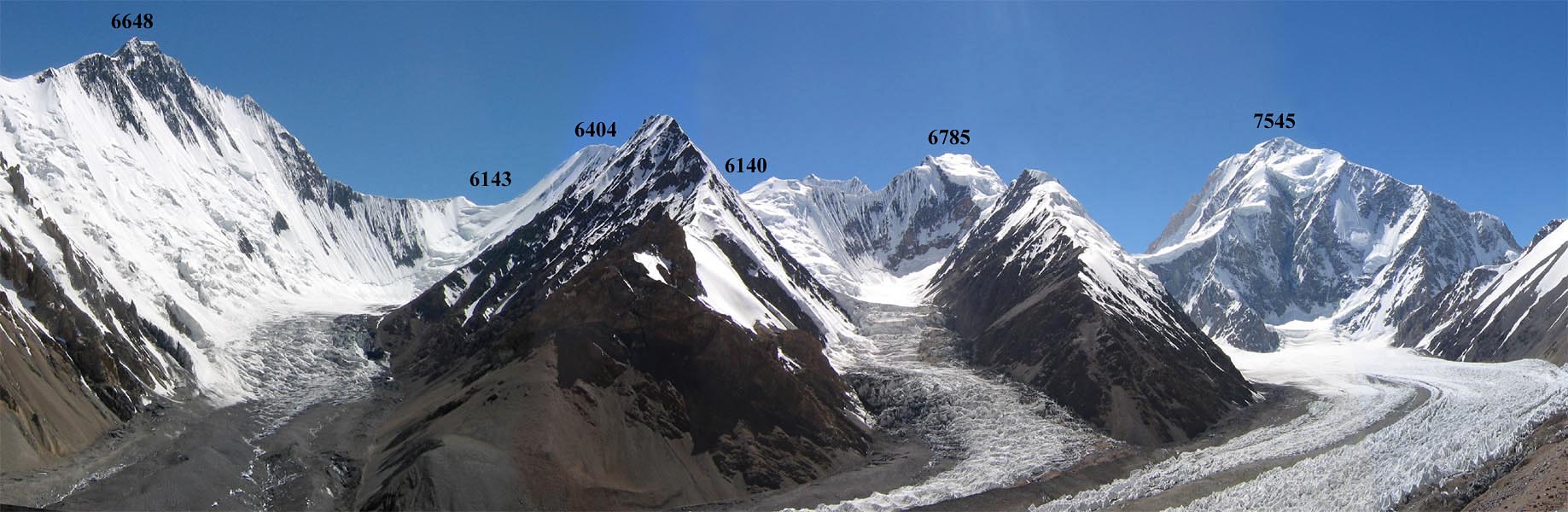
Karakoram
by Pierre Neyret
The
great crossing through Karakoram
2011
Shimshall
Pass 4700m
Lukpe La 5600m
Braldu Brakk 6200m
Sim La 5450m
Dom Peak 5830m
|
It is in place name Urdukas in summer
2005 I met Pierre by big chance, as big
as the great big walls of the Trango towers
as we watched both on a rock together. Chance?
not that much. I soon met a man who is totally
passionate about the mountains of Karakoram,
this passion has quickly bound. I would
once again talking about his passionate
expeditions.
Like every year, Pierre holds a magical
journey in the ice of the Karakoram range,
near the Snow Lake, not far from the Blank
on the Map of the pioneers and the absolute
dream. Commercial expedition? Yes but not
only. The routes are still organized by
Pierre ran away from big roads and I know
myself that passes between landscapes and
virgins peaks of these far regions are among
the finest in Asia and the world, the Baltoro
seems almost bland next to ... It is a wonderful
playground, adventure and beauty for the
eyes, Pierre knows it better than anyone.
It can even take you to the virgin peaks
that abound in the region as Braldu Brakk
(6200m) this year.

Jahangeer Shah |
But let Pierre Neyret speak on his travels:
"I am always astonished to meet nobody
in these unique areas in the world. Sure,
it's a little bit complicated to organize,
it's a big job, you really need want to
have! There are more simple work as guiding!
I am fortunate to live a kind of golden
age when everything is to do and write on
a huge territory.
An email from a customer that made me recently
happy: "It is true that the scenery
is exceptionally beautiful, that the meetings
are rich and varied but it is only a small
part of the success of this adventure in
my feel ... I truly believe that your joy
to you and Jahangeer is the reason for the
Great Crossing exceptional! "
This story with Jahangeer which began 8
years ago, is my best mountains story !
Jahangeer is like me, in love with what
he calls "the white paradise"
and is determined to pursue these adventures.
We are strong with a rich common experience
of these great glaciers. The friendship
between us is largely responsible for the
success of these expeditions. Jahangeer
lives in Aliabad (Hunza), I met him for
the first time in my first experience on
skis Hispar Biafo in 2003. He had never
skiing before, people Hispar promised death
in view of the prevailing winter conditions
on the mountain that year, but he trusted
me and went up with me. Since then, he participated
in every experience. He is the only guide
Pakistan to do that. It has a small agency
called Adventure Guide Pakistan. We did
discover Snow Lake to nearly 60 people,
and we will continue! ".
Here the way 2011 on a map:
Especially for Blankonthemap, Pierre Neyret
here tells us some of his best images in
2011. I, who had the chance to go to these
beautiful places, I can say at the sight
of these pictures, I really want to return
quickly. If you feel like it, it's easy,
just ask to Pierre Neyret !


©
Blankonthemap - Jun. 2011
|
|
|
|
|
|
|
|
|
|
|
|
Blankonthemap
INFO N°46
24 th january
2011
|
|
Nangma
valley with Anne Bauvois
|
As you know, Blankonthemap is frend
with those who are reinventing the mountain
and less to those who flock to the main
summits, with guarantee for fame, but
often nothing more than vanity, purchased
a sudden thousands of Euros. When Anne
introduced me to explore the Nangma
valley, I fell in love with its romantic
way to practice mountainering and recall
me the story of the pioneers. Here woman
sensitivity although rare in the guide
little world is probably something to
do.
Then, lets you tie immediately with
Anne on the high and majestuous Big
Walls of Nangma valley for here exploratory
expedition, romantic, joyful she offers
!
It is thanks to Marco who has
traveled the Himalayas for several
months on foot and by bus, has
germinated the idea of exploring
Nangma. The team is quickly made
up of 4 enthusiasts peoples for
a simple logistic and 2 distinct
purposes. Marco and Fred go on
a big wall 600m high: essentially
a rock face where North oriented
systems of cracks are getting
lost in an arch overhanging ...
Fred (another) and myself will
remain on a lightweight technical
alpine approach with a small light
and versatile equipment.
At a day's walk from Hushe,
our porters carry the equipment
up to 3900m CB, ideally situated
along a creek in a meadow bordered
with alders. Once the carriers
have gone, we stay alone with
dzos in pasture up there. In Skardu,
we made full of food: fruits,
vegetables, eggs, rice, flour,
dried apricots, seeds, tea, but
some bars and canned Nestlé
outdated. We cooked by ourselves.
Balance sheet of the expedition:
Fred and Marco open "Zen
& the Art of Motorcycle Maintenance"
630m 6c and A3. Big wall very
steep north face of Roughkangchan
III (4630m). Opening the bottom
capsule technique. Final assault
of 7-day wall. Directions primarily
crack on good rock cleverly maneuvering
among the huge overhangs located
at 2/3 of the wall. Descent on
foot in steep grass slopes.
|
Fred and I are opening a path
to the unknown peak (5400m) above
the Roughkangchan III. Technical
Alpine peak in a camp and go back
the next day (AD, mixed 60 °
slopes, rock 4). Below, a glacial
basin surrounded by mountains
mixed probably never climbed.
He will return ...
Opening the bottom of a climbing
lane on the south side of the
CB (200m D +, A1 and 5c).
Featured many technical routes
(through) and to attempt to Drifika
6200m (6400m) in alpine technique
to the day from a bivouac at 4900m.
We underestimated the height of
the face and vitreous ice greatly
slowed our progress. Impossible
to attempt a camp up there with
our equipment without leaving
some fingers... so we return down
cause of the descent is long and
delicate.
Logistics CB full of surprises:
The dzo toppled stones of the
kitchen and all our vegetables
are eaten in the first week! Stoves
work very poorly as a background
gas was mixed with kerosene. Youth
Hushe come and sing and give us
preparation of chapatis. We let
them taste our manufacturing bread
cooked in a small oven baked granite.
pictures here
joint:
|
|
|
Marc Vanpé:
Mountain guide, hardy adventurer.
|
|
Frédéric Jolly:
Enduring engineer, long amateur
trails.
|
|
|
Frédéric Hasbani:
Ingenious engineer and climber.
|
|
Anne Bauvois:
Mountain guide, enthusiastic.
|
Blankonthemap do not
like too much marketting promotions
but I have no scruples to advise you
Anne for your next mountain trip.
I am very familiar with Anne for having
rented his services a few days of
glorious summer in the Parc des Ecrins
(France).
If you like to map routes off the
beaten path, you prepare Anne pieces
and knows how to share his passion
for the mountains!

Anne Bauvois
Le village de Hurtières
38570
France Tél.: 0033 670 101 837
©
Blankonthemap - Jan. 2011
|
|
|
|
|
|
|
|
|
|
|
|
|
Blankonthemap
INFO N°43
1 november 2010
|
Picture
of the month

Urdukas by night
Shot with a D200 and a Sigma 15 mm lens
at iso 100 with 2 minute exposures in
the moonlight
©
Blankonthemap - Nov 2010
|
|
|
|
|
|
|
|
|
|
|
|
|
Blankonthemap
INFO N°42
1 octobre 2010
|
The
extraordinary story of a Russian
expedition to the borders of the
Chinese Karakoram
|
Since 2006, I liked to share with you
surpises findings in the corners of the
web. With good luck, I came across this
website counting an expedition entirely
unique wich Blankonthemap love to tell you.
The website tells the extraordinary expedition
of six russians members in a mountaineering
trek with the blessing of Russian Mountaineering
Federation during the months of July and
August 2006. Under their heavy backpacks,
they explore the huge northern faces of
K2, Broad Peak and Gasherbrums. This site
contains a collection of pictures with worth
exceptional quality:
The site is in Russian which makes its
understanding quite difficult but with Google
Translation can easily translate it:
The members of the expedition:
|
|
|
|
|
Jdanov, Ivan Nikolaïevitch
Borning date: 01/08/1973
Leader, Photographer
|
Andrey Lebedev
Borning date: 27/07/1956
Co Leader , vidéo operator
|
Rashitovich Rustam
Bikchurin
Borning date: 06/10/1979
Steward
|
|
|
|
|
|
|
|
|
|
Zharov, Andrei V.
Borning date: 01/02/1980
Photographer
|
Timoshenkov Sergeevich
Alexey
Borning date: 16/12/1985
Doctor
|
Tarin Dmitry
Borning date: 09/03/1982
|
This website tells the whole story in
every details with great reinforcements
of pictures, maps and even videos, and always
with great humor!

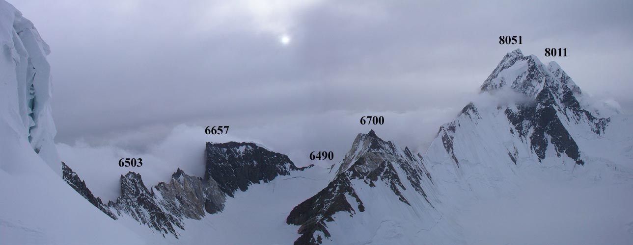
The route crosses several high passes
largely unknown, including 3 over 6000 meters
and a final climb to 6631m in the northern
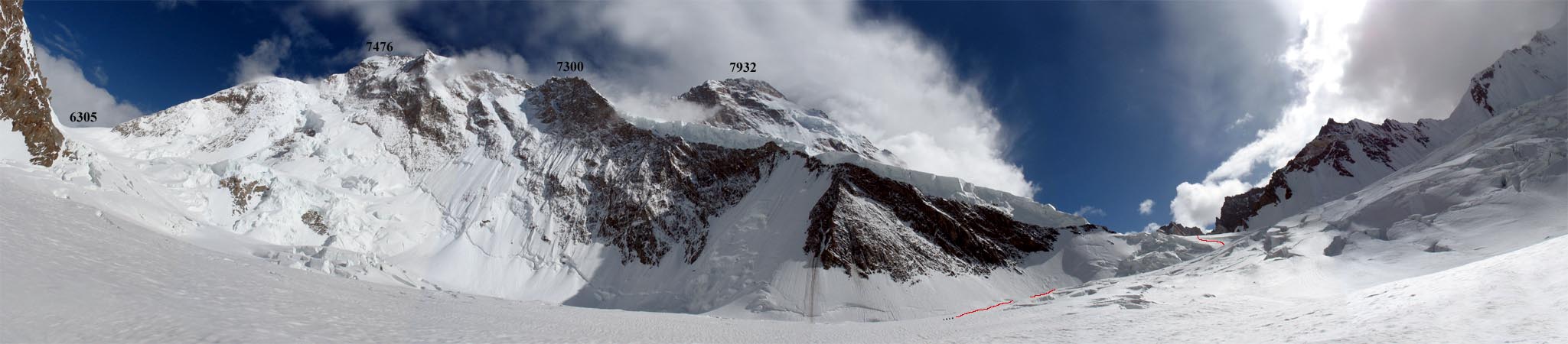
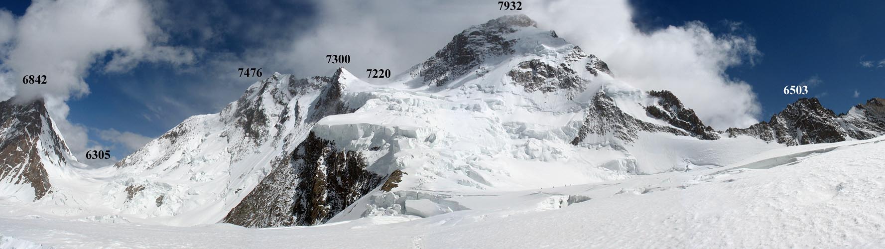
face of Gasherbrum IV (7932m) Chinese side,
never explored! These cheerful companions
explore the unexplored valleys and shows
us the wonderful photographs some of the
most fantastic lanscapes on the earth, such
as K2, is rarely photographed his face is
finally under our eyes!
The commitment is total. A broken leg
and is certain death without assistance
or satellite phone. The autonomy and freedom
require heavy bags for 35 days of walking!
They will return all emaciated, the member
Rustam Rashitovich Bikchurin even having
lost 17kgs!
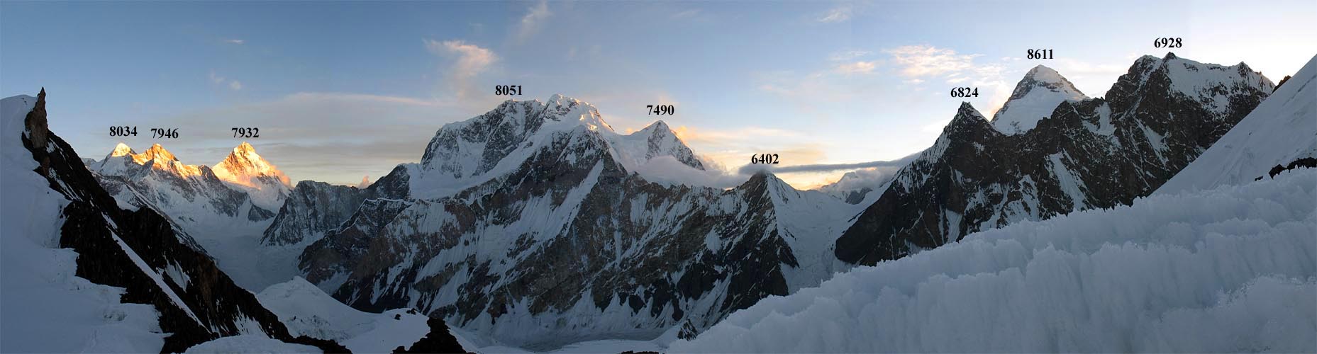
Some of the best pictures with comments:

Picture taken at Northwestern Skiang
Kangri.
|

Picture taken east side of Skiang
Kangri (7545m)
|

Northern faces Gasherbrum II (8034m),
Gasherbrum III (7946m) and Gasherbrum
IV (7932), Broad Peak face (8051),
Sella Pass (6063) between the peaks
(6824m and 6928m) with just the right
K2 (8611m).
|

Hidden Peak (8080m), Gasherbrum
II (8034m) and Gasherbrum III (7946m)
northern faces.
|

Gasherbrum IV ascent: 5800 Plateau
in the north face of Gasherbrum
IV between camps 1 and 2 of the
icefall.
|

Gasherbrum IV ascent: anorama Camp
6074m to the south-east.
|

Gasherbrum IV ascent : (6631m high
camp), looking north-west with Falchan
Pass (6490m) and Broad Peak (8051m)
in mosoon.
And an unforgetten picture of the
northern face of K2 (6805x4744 pixels!,
2,02 MB!!):
|
... and also the story
of the Kongur exploration (south Kashgar)
here :
I'm interesting for contacting
members of this expedition (I tried without
success).
thank you!
©
Blankonthemap - Oct 2010
|
|
|
|
|
|
|
|
|
|
|
|
|
Blankonthemap
INFO N°41
12 june 2010
|
|
Younghusband
map (1888) from Bejing to Kashmir
Perhaps could you
imagine the importance of this incredible
travel make by Francis Younghusband
in 1887 in central Asia and, ate
the end, look for a pass to go through
the Karakoram wall, the Muztagh
pass. Younghusband's crossed the
pass 123 years ago and won him considerable
fame and became one of the defining
moments of the "Great Game"
phase of mountain exploration in
the Karakoram.
During the amazing
trip of Schlagintweit brothers,
Adolf Concordia was the first to
discover the Muztagh Pass 1855.
The scond was SF Younghusband. It
certainly was a remarkable achievement
to lead a group of untrained and
ill equipped locals down such a
feature using only a single pick
axe, a few yards of pony tack and
the unravelled turban of Wali, his
faithful servant. The third crossing
of this pass only happened in 1929
when Ardito Desio (later famous
as the leader of the successful
1954 Italian K2 expedition) made
a crossing as part of the Duke of
Spoletto’s large scientific
expedition. Bernard Odier’s
team in 1990 claimed the first crossing
by a ski expedition. Nowadays, the
pass still make people dreams.
|

|
See other Baltoro maps:
A lire
sur ce thème :

|
|
|
|
|
|
|
|
|
|
|
The mountainous area of northern Kashmir is still today very
little visited, little known even totally unknown because it's
prohibited. The hostile surroundings of high altitude, the Kashmir
war, Islamic areas not open to tourism, unfindable maps, in short,
northern Kashmir still remains today distant from science, humans
and the world. It's still "Blank on the map" in the
mountains of Kashmir, as was written by Erik Shipton, an English
adventurer, in his well known adventurous recital, an adventure
that he lived in Kashmir, in a border area of the Korakoram (Korakorum)
at the end of the 30ties.
This site modestly tries to correct this gap. It approaches
the important exploration dates of the far Kashmir mountains,
it brings back into light the glorious period but completed, the
great national expeditions, amongst others, Italian and English,
as well as the great mountaineering conquest in Kashmir which
marked the history of the world mountaineering. The area is still
highly desired by the Chinese, Indian and Pakistani conquers.
You will find a chronology of this conflict with a summary of
the considerable geopolitical stakes of this area, center of the
world, crossroads of people and their cultures. You will read
the suggestion of a geographical isolation particulary in northern
Kashmir that probably contributed to worsten the painful partition
of India and Pakistan and which inevitably led to the first Kashmir
war in 1947, a strong argument still existing up to this date.
Recently, in 1984, India disputed the borders set up with the
argument "cartographic oppression" non existing at that
time and 35 yrs after the partition of the border set up of the
northern territories of Kashmir. For that reason, India felt it
right to go to war on the highest world glacier of Siachen in
Pakistan.
Finally, to try to demystify the mountainous zones of northern
Kashmir, a unique orographic area of the world, however prohibited
because of wars or too far and unaccessible, this site proposes
a series of geographical maps and satellite images of great interest.
You'll find geographical inspections of the Himalaya and Karakorum
massif, of Nanga Parbat, of Hindu Kush and the Hindu Raj massif,
but also rare documents of the far away countries of the Siachen
glacier, valley of Shaksgam and Shyok or the far platform of Aksin
Chin surrounded by the mysterious Aghil massif. The cultural aspect
is also examined, trying to describe the people and tribes who
are part of exceptional ethnic’s patchwork of the area. Finally,
to decorate this, there are 300 personal photos of mountains and
the trip from various aspects.
Northern Kashmir is an isolated and contrasted area, deserted
and arctic, largely admired and always jealoused on. This site
is an invitation through time and one of the most beautiful mountain
areas, to dream, one might want to dream of the last unknown soil
of the world. If this could be of use to you for any details or
future expeditions to Kashmir, it would be my greates award and
please feel free to contact me on this subject.
Have a good trip !
Bruno Collard.
Contact
:


©
Blankonthemap 2009

|
|