The Karakoram range mountain range is 400km long
and called "Khara-Khelem" which means "big barrier"
in Mongolia and "Tsagaan-Kherem" which means "white
barrier" in Chinese. A pass of the Karakoram range pass, which
means the "black Rocks" pass in turkish, allows to go
through the sharing line of the waters between the Indian Ocean
and Central Asia for those existing caravans that travelled the
silk road - this also, to avoid the Karakoram range mountain range
of the east - this pass gave its name to all the mountain range
and is today at the argued border of China and India (north of Ladakh).
Aside the colour of its black rocks, the Karakoram range pass has,
for a long time, had a bad reputation based on the myths which the
merchants, who took these high commercial mountain roads, told about.
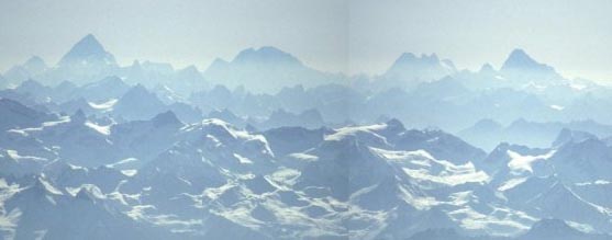
Everything concerning this massive is extreme and unique on Earth.
It's probably the highest mountain region on the globe (an average
of 3800m altitude, world record). Surrownded and isolated by the
six highest mountain ranges of the world, which are - Himalaya,
Hindu Kush, Hindu Raj, Pamir, Kun Lun and Tien Shan, this area is
in the heart of the strongest orographic earth knot, one of the
wildest of the world. The mountain range has 4 of its 14 summits
more than 8000m (K2, Broad Peak, Gasherbrum I and Gasherbrum II)
10 out of 30 are the highest mountains on earth, more than hundreds
of 7000 over a stretch of only 400km by bird's flight. These aglomerations
of mountains called "group" or "muztagh" (Muz
means ice and Tah mountain - similar to Mont Blanc or Dhaulagiri)
reach for the sky, whereas, some of the longest glaciers of the
world, the 8 longest aside the polar regions, erode non-stop the
earth's crust. These glaciers melt during summer at an incredible
speed under the burning sun as the temperature goes up to 40°C,
thus transforming the rivers into fiery mountain streams, the highest
sediment volume of the world. The strength of the size of huge buildings.
To travel in the Karakoram range is to witness one of the world's
biggest, active geological demonstration.
We note approx 135 important glaciers in the midst of
the mountain range. Underneath are the main ones (excluded are those
coming from ice caps) Please notice that even though the Karakoram range
glaciers are far away from the polar region, they compete with the polar
glaciers.
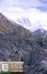
Vue from the summit of Nanga-Parbat to the East, from left to right
(North to South) :
K2, Broad Peak, Gasherbrums Group and Masherbrum.
Vue from the summit of gasherbrum II, to the Noth west, from left
to right,
Broad Peak (center left), Abruzzi ridge of K2 in the backside
the Skyang Kangri. Far on the skyline, the Hindu Kush and Pamir.
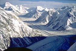
Godwin Austen glacier at the foot of K2, down
is Concordia and the Upper Baltoro glacier to the far south (Chogolisa
-7665m- on the skyline)
We find the highest concentration of glaciers of the
Asian continent in the Karakoram range mountain range, 8 of which are
longer than 50km ; 20 more than 30km ; the following glaciers, Batura,
Biafo, Hispar, Panmah, Siachen, Saser, Chogo Lungma and Rimo are all
over 350km2 surface, the total stretch of this ice is above 16,000km2
and represents an enormous reserve of soft water which is of great richness
for all the downstream regions known for their bareness and dryness.
The waters of the melting glaciers bring an important contribution to
the Indus river in the south and Yarkand to the north and bring life
to approx 130 millions of people. When Jinnah stated that "Indus
is the jugular vain of Pakistan" he underlined a geographical statement
of strategic importance still valid today.
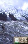
Biafo glacier to the Snow Lake plateau :
The Geological and Climatic Exception of the Karakoram
range :
The first ice stage of the Himalaya can be dated back
to the inferior Pleistocene and started in the Karakoram range mountain
range, because of its septentrional position and its average altitude.This
ice stage was followed by strong erosion phenominas and bareness. The
retreat of the Pleistocene ice made apparent the base of the rocky surface
of the Karakoram range mountains and furthermore, washed away huge masses
of sediment into the valleys downstream.The recent orogeny of the Himalaya
and Karakoram range represents the youngest evolutionary stage of the
Alpino-Himalayan belt which started in the superior Paleozoique (pre-quarternary).
Thereafter, Himalaya, Karakoram range and other neighbouring mountain
ranges, during Holocene, became what they are today and obtained their
tectonic and orographic aspects as we know them today. The morphology,
so characteristic of the Karakoram range mountains, was thus shaped
by the climatic morphology and directed by global changes of climat
during the quaternary as well as its movements at an exceptional elevation.
The Himalaya and Karakoram range have not yet reached their isostatic
balance seeing the global elevation of the sheets is beyond the erosive
work and the bareness which is exceptionally active.
The Sudden Surges of the Glaciers and their devastating
results :
Rimo glacier (North Siachen area)
The Karakoram range glaciers undergo regular upsurges which are difficult
to explain by those who study them. In only a few years, the silant
ice tongues can become enormous and be devastating flows of ice and
rock. Already, this suddeness was known to the pilgrims who travelled
the silk roads at the east of the mountain range. The three dangerous
glaciers of the Shyok valley, when they were in rapid movement, would
block the uphill valley - even their names are based on cataclismic
phenomenas they created : Chong Kumdan (means "big obstruction"),
Kichick Kumdan (means "small obstruction"), the inhabitants
afterwards gave it another name - Thangman (means "scar").
The glaciers closed the roads of the pilgrims. After an ice upsurge
the road which was already difficult, became impossible. Thereafter,
a little lake came into being, just behind the obstruction and when
the glacier retreated, it exploded under huge accumulation of water.
The flood, not foreseeable, was of extreme violance : in June 1835,
it destroyed everything for 250km up to Deskit and Tegur, at the Nubra
junction. The caravans had no other choice but to wade through the river
and go through the high desolated Depsang plains.
Thangman Glacier (Kichik Kumdan) fall down quikly
in Shyok valley and build a dangerous wall of ice.
These unexplained sudden glacier surges often occur in the Karakoram
range mountain range and this, in spite of a general retreat of the
glaciers of the rest of the world. Since a century, 26 surges were detected
in the Karakoram range, rapid advances were noted that involved at least
17 glaciers : the only other explosions known are in the Yukon range
(Alaska) and the arctic islands of Svalburd. However, all the sudden
rises of the Karakoram range glaciers have not yet been observed.
Recently, the expansion of the Pumari Chhish glacier,
between 1994 - 1996, affluent of the Hispar glacier as well as Chiring
and main affluent of the Panmah glacier, are recent life proofs. Below
are extracts of two scientific reports followed by witnesses of the
greatest 19th century explorers.
The Rapid Advance of the Pumari Chhish Glacier
since 1985 :
The Pumari Chhish is approx 7 km long and flows south
from the main Karakoram range range. It's one of the main affluents
of the Hispar glacier which is 62km long and starts west from the Hispar
pass (5150m), thereafter, it flows into the Hunzan river. This glacier
has received an enormous amount of growth since 1985. Hereafter are
extracts of a scientific observation report, edited by the University
of Science of New Hampshire and translated by the webmaster of this
site.
The Pumari Chhish glacier is mainly fed by the avalanches which come
from the north face of the mountain which has the same name, the Pumari
Chhish (7429m) the Khinyan Chhish (7854m) as well as unknown inferiour
summits. The avalanches deposit the snow, the ice and the rest into
a small basin on a gentle slope at 4600 - 4700 m. The 4 km, inferiour
to the Pumari Chhish glacier go slowly, little by little, down from
this small basin of accumulation of 400m into an at least 55m large
bowl.
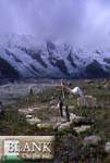
Kani Basa glacier, up of Hispar glacier
The explorer Conway went through and examined the Hispar and Pumari
Chhish glaciers in 1892 and noted the following "It's remarkable
to see that, whereas the Lak glacier becomes considerably smaller, the
Chur glacier (Pumari Chhish glacier), its immediate neighbour, has,
on the contrary, become considerably bigger. It overflows its moraines
and poars a huge wave of remains over the surface of the Hispar glacier"
Non of the other explorers, eg the Dr Kooncza and Cahate in 1908, the
Bullocks couple in 1910 (their map shows a gentle junction) nor Erik
Shipton (his map set up in 1939 gives more or less the same junction)
gave any indication of a difficult path of this glacier. No mention
was made of the Pumari Chhish glacier in the revues edited by Mason
(1930) Hewitt (1969) Mercer (1975) or Mayewski and Jesclike (1979).
Hard walk on Pumari chhish glacier
Our own observations of the glacier started in 1985 when the glacier
was crossed during a recognition trip from the Hispar basin, a study
which was part of an hydrologic project. At that time, it was easy to
cross the glacier. There was a path easy to detect on the two lateral
moraines and through the glacier, a path that was used by the shepards
who took their yaks to their summer pasture fields uphill of the Hispar
glacier. The surface of the ice was more than 10 meters under the lateral
moraines. The aspect of the glacier had changed little when we took
the road the second time for the Hispar pass on August 8, 1987. However,
in 1988, the tongue of the glacier had become thicker by at least 20
m. There was no way to cross the glacier and we had to cut our steps
through the ice with our tools to advance.
Other observations were made during July and August 1989 when the scientific
base camp was established in Bitammal, 3km west from the glacier. The
glacier's tongue had become that much more thicker and the ice was between
16 - 22m above the lateral moraine. The glacier also progressed like
1 km, nearly reaching the middle of the Hispar glacier which, at that
particular point, was 2 - 2.5 km large. The whole length of the Pumari
Chhish glacier had crevasses, to a point, where it became impossible
to cross. The pasture fields next to the ablated valley and close to
the Hispar glacier, uphill of the Pumari Chhish glacier, had been seperated
and the yaks had to stay in Bitammal. A brief survey towards the top
of the Pumari Chhish glacier did not show more snowfall, ice, or rocks
indicating an avalanche or an important land slide. The nature of the
surge of the Pumari Chhish glacier described by Conway, ressembles incredibly
to our own observations during the 1989 summer, which leads to think
that the glacier had known at least two rapid seperated growing periods
during one century.
As for my own observations concerning the Pumari
Chhish Glacier :
Moraines du glacier
du Pumari Chissh
Tombe d'un porteur tombé dans une crevasse
du Pumari Chhish aux abords du glacier
In 2000, I myself, crossed the Pumari Chhish glacier, going down the
Hispar pass. I noted in my travel book that it was very much distorted.
"At the moment, we are preparing ourselves to cross the Jutmo glacier
(the local name) an affluent of Hispar who directly descends from the
north circle formed by the Kanjut Sar mountains (7760m) of the east,
the Yutmar Sar (7330m) north, the Khumyang Chhish (7852m) west. The
glacier is very distorted, it's like a labyrinth of a number of sharp
rises in the grownd seemingly impossible without climbing tools and
between profound crevasses - thus we have to go around the obsticles
hoping to find the best way by our own intuitive initiatives. Everyone
goes by its own gut feeling and we loose each other. It's a real orientation
race, Hassam, the porter, seems to be the best at this game, it looks
like he found the solution befor us : Hassam and I are lost : but not
as bad as Mohammed, already at a distance of 55 meters uphill of the
glacier : Ali and Rasoul are still behind and have difficulies to follow.
We remeet on the other side of the glacier after two hours of struggle.
We go up the moraine and find some greenry. There we find the grave
of a porter and Hassam tells us that he died the year befor on the Jutmo
glacier. Rearly, this glacier gives cold shivers".