|
|
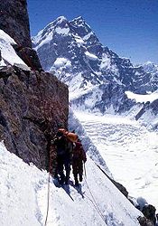
CLIMBS
IN SIACHEN AREA
-page 3/3-
|
|
|
|
|
|
| |

|
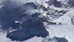
Here joint maps of Siachen area and around
: |
|
|
|
|
|
|
|
|
|
|
|
|
|
|
|
|
|
|
|
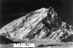
Saltoro Kangri group -c7,495/c7,742m- :
|
 Saltoro
Kangri mean " yellow mountains ". Saltoro
Kangri mean " yellow mountains ".
The Saltoro Group is one of the most powerfull of all the Karakoram
range. 3 of the highest summit of the group are still virgin, cause
of the Pak/India dispute territory. The Saltoro II (c7,705m) is the
highest summit without climb that it make one of the most challenging
mountains of the world.
|
Saltoro Kangri I -c7,380m-:
|
 In
1935, british Expedition led by J. Waller with John Hunt attempted Saltoro
Kangri. They camped on the Peak 36 glacier. In
1935, british Expedition led by J. Waller with John Hunt attempted Saltoro
Kangri. They camped on the Peak 36 glacier.
In 1962, Japanese-Pakistan expedition led by T. Shidei made the first
ascent of Saltoro Kangri
 1972
'Shimla Agreement' was signed between India and Pakistan. It failed
to clearly demarcate the border along this glacier. 1972
'Shimla Agreement' was signed between India and Pakistan. It failed
to clearly demarcate the border along this glacier.
In 1975, Japanese expeditions led by S. Yamamoto attempted Saltoro Kangri
I.
In 1981, Indian Army expedition led by Col. N. Kumar reached the upper
glacier via the Nubra valley. They climbed Saltoro Kangri I, Sia Kangri
I, reached Indira Col (West), Sia la, Turkestan la and Saltoro Pass
(PK 36 glacier pass).
|
Saltoro Kangri II (K35) -c7,705m- :
|
 Never
climbed. Never
climbed.
|
Saltoro Kangri II, East summit -c7,518 m- :
|
 Never
climbed. Never
climbed.
|
Saltoro Kangri III -c7,495 m- :
|
Never climbed.
|
Sia Kangri Group -c7,422/c7,273m- :
|
Its broad icy summit was climbed in 1934 by a strong international
expedition directed by G.O. Dyrenfurth, in which in particular André
Roch takes part. The team, after attempt Hidden Peak brings back two
beautiful successes on Sia Kangri I (Queen Mary Peak) -7422m -, and
Baltoro Kangri (Golden Throne) -7260m -.
Note finally that this border area remains dangerous: in 1986, Americans
climbers of an indo-American expedition went back just under the summit
cause of an Pakistani forces attack, letting the Indians cimbers go
at the top.
|
Sia Kangri I (Queen Mary peak) -c7,422m- :
|
Sia mean " Rose ", Thi is the "Rose Peak".
1974 : Austrian expedition led by W. Stefan climbed Sia Kangri from
SW.
1979 : Japanese expedition led by R. Hayashibara climbed Sia Kangri
from the Conway Saddle, descended its S face to the Siachen glacier.
They trekked out via Bilafond (Saltoro pass).
1981 : Indian Army expedition led by Col. N. Kumar reached the upper
glacier via the Nubra valley. They climbed Saltoro Kangri I, Sia Kangri
I, reached Indira Col (West), Sia la, Turkestan la and Saltoro Pass
(PK 36 glacier pass).
1986 : Sia Kangri was climbed by the Indo-American expedition led by
Maj. K.V. Cherian and Leo Lebon. They traversed the glacier. Seven Indians
reached the summit and Americans reached Indira Col (West).
|
Sia Kangri II -c7,325m- :
|
In 1956, Austrian expedition led by F. Moravec climbed Sia Kangri
West.
In 1975, an Austrian expedition led by Gunther Schutz crossed over Bilafond
(Saltoro pass) and attempted Saltoro Kangri II.
In 1981, dutch expedition attempted Saltoro Kangri II from the west.
|
Sia Kangri III -c7,273m- :
|
[To complete ]
|
Sia Kangri IV -c7,315m-:
|
[To complete ]
|
Hardinge Peak (Sia Chhish) -c7,024m- :
|
First attept and success in 1983 by an Italian's teal (leader G. Mallucci).
|
Sherpi Kangri I -c7,380m-:
|
 In
1972 'Shimla Agreement' was signed between India and Pakistan. It failed
to clearly demarcate the border along this glacier. In
1972 'Shimla Agreement' was signed between India and Pakistan. It failed
to clearly demarcate the border along this glacier.
In
1974 Japanese expedition led by T. Tanaka attempted Sherpi Kangri II
via S ridge. This was the first expedition allowed from Pakistan after
the 'Shimla Agreement'.
In 1974, British expedition led by D. Alcock attempted Sherpi Kangri.
In 1976, Japanese expedition made first ascent of Sherpi Kangri, led
by H. Hirai.
|
Sherpi Kangri II -c7,303m- :
|
 [To
complete] [To
complete]
|
Singhi Kangri (Mount Rose) -c7,202m (c7,751m)-
:
|
 Singhi
mean "Difficulty" and was first christened by Sahib Afraj,
indian officer during Visser expedition in 1835. Singhi
mean "Difficulty" and was first christened by Sahib Afraj,
indian officer during Visser expedition in 1835.
Singhi Kangri was first climbed in 1976 by seven mountaineers from Tohoku
University, Japan. This team climbed the North Face and North West Ridge
above the Staghar Glacier having crossed both the Bilafond (Saltoro
Pass) and Turkestan La from Pakistan (the area of today's disputed territory).
In 2002, unconfirmed reports suggest that an Indian Army expedition
organized by the Corps of Engineers and led by Col Dinesh Kumar, made
the second ascent of 7,751m Singhi Kangri close to the head of the Siachen
Glacier. In the process members of the team also made the first ascent
of a subsidiary 7,195m summit referred to as Mercury. The report suggests
these two summits were reached on the 2nd October. Other members of
the expedition are said to have subsequently climbed Teram Kangri I
(7,464m), II (7,407m) and III (7,382m). The group also climbed to the
Indira Col at the head of the Siachen.
An indian expédition made oniy the sec-ond-ever attempt to climb
7,202m Singhi Kangri near the head of the Siachen on the border with
China. They established a new base camp on September 16 at 5,100m and
Camp 1 at 6,325m on the 21 st 2007. having climbed the west face. It
appeared that the hardest part of the climb was over, and they deemed
oniy one more camp necessary before making a summit attempt on both
Singhi Kangri and Pt. 6,850m. However, poor weather and dangerous snow
conditions prevented further progress, and they abandoned the route
on the 29th.


|
Tawiz Peak (Amulet Peak):
|
Once some of the Yarkandis descended the Ghyari nala and took away
a Balti woman with them to their glacier village. To take revenge, Baltis
contacted an important mullah, who gave them a tawiz (amulet) which
was to be placed on the Bilafond (Saltoro pass). Mullah instructed them
to return via the Nubra valley. However the Baltis, after placing the
tawiz on the pass returned the way they had come. Soon afterwards a
great storm visited the Siachen glacier and destroyed the settlements
and only the rocky desolation remained. The priests say that the calamity
would have been greater had they followed the directions fully. Because
of this lapse in following the instructions wild roses were not destroyed
by the storm. Today roses grow in plenty near the snout and in the lower
valleys, though the entire glacier is barren. The glacier is called
Siachen (Sia-rose, chen-place of) -the place of roses.
1956: Imperial College British expedition led by Eric Shipton climbed
Tawiz and visited several passes.
|
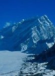
Teram Kangri group -c7,195/c7,410m- :
|
 The
famous frozen Teram plateau was explored like various surrounding pass.
This high plateau is unique by its size at the altitude of 6200m, surrounding
by high mountains on all its accesses. Harish Kapadia and Ryuji Hayashibara
for the first time would reached the plateau in 2002 during indo-Japanese
expedition in the area. The Italia pass (passo Italia) was also crossed
by this expedition 73 years after the first time. The
famous frozen Teram plateau was explored like various surrounding pass.
This high plateau is unique by its size at the altitude of 6200m, surrounding
by high mountains on all its accesses. Harish Kapadia and Ryuji Hayashibara
for the first time would reached the plateau in 2002 during indo-Japanese
expedition in the area. The Italia pass (passo Italia) was also crossed
by this expedition 73 years after the first time.
|
Teram Kangri I -c7,722m-:
|
 Teram
Kangri I and II were climbed by the 1975 Shizouka University expedition.
These Japanese first climbed the South Ridge of Teram Kangri II from
the upper Siachen Glacier and then traversed the connecting ridge northwest
to the main summit. Four years later another Japanese team, this time
from Hirosaki University, climbed Teram Kangri III via the South East
Ridge from the Singhi Glacier. All these Japanese teams approached from
Pakistan. Both Teram Kangri I and II have received second ascents, the
former in 1992 and the latter in 1978 by Indian Army expeditions, both
approaching via the Nubra Valley and Siachen Glacier. Teram
Kangri I and II were climbed by the 1975 Shizouka University expedition.
These Japanese first climbed the South Ridge of Teram Kangri II from
the upper Siachen Glacier and then traversed the connecting ridge northwest
to the main summit. Four years later another Japanese team, this time
from Hirosaki University, climbed Teram Kangri III via the South East
Ridge from the Singhi Glacier. All these Japanese teams approached from
Pakistan. Both Teram Kangri I and II have received second ascents, the
former in 1992 and the latter in 1978 by Indian Army expeditions, both
approaching via the Nubra Valley and Siachen Glacier.
In 1992, an Indian army team led by Col. M.S. Gill climbed Teram Kangri
I. No details available.
In 2002, an indian expedition climbed Teram Kangri I (7,464m), II (7,407m)
et III (7,382m). They also climbed the famous India Pass.
|
Teram Kangri II -c7,406m-:
|
 1975
: Japanese expedition led by H. Katayama made first ascents of Teram
Kangri I and II, coming over Bilafond (Saltoro pass). This was the first
expedition to cross over into the Siachen glacier from Bilafond (Saltoro
pass) with permits from Pakistan. 1975
: Japanese expedition led by H. Katayama made first ascents of Teram
Kangri I and II, coming over Bilafond (Saltoro pass). This was the first
expedition to cross over into the Siachen glacier from Bilafond (Saltoro
pass) with permits from Pakistan.
1978 : Indian Army expedition led by Col N. Kumar approached from Nubra
and climbed Teram Kangri II. This was the first Indian expedition to
enter the glacier from the Nubra valley after the 1930 Italian expedition
by G.Dainelli (though Indian security parties have reportedly visited
the glacier till Bilafond (Saltoro pass)).
In 2002, an indian expedition climbed Teram Kangri I (7,464m), II (7,407m)
et III (7,382m). They also climbed the famous India Pass.
|
Teram Kangri III -c7382m-:
|
In1979, a japanese expedition led by S. Hanada crossed over Bilafond
(Saltoro pass) and made the first ascent of Teram Kangri III.
In 2002, an indian expedition climbed Teram Kangri I (7,464m), II (7,407m)
et III (7,382m). They also climbed the famous India Pass.
|
Teram Kangri IV -c7,300m- :
|
Summit seems virgin.
|
Thugu Peak -c6,158m-:
|
Dam and Kapadia explored the Rassa Glacier and unsuccessfully attempted
a 6,158m peak, named Thugu, close to Base Camp. Poor weather and the
prevailing international situation at the time curtailed the expedition
and the members returned home earlier than planned.
|
Sources :
All informations mainly coming from,
Ø The American Alpine Journal, 1996 to 2004 editions
Ø Himalaya in Alpin Style by Andy Fanshawe & Stephen
Venables, (Arthaud - France), 192 pages, 1996 edition
Ø The Karakorum, Mountains of Pakistan de Shiro Shirahata
édition Ferezsons (pvt.) ltd
Ø Les plus belles montagnes du monde (Glénat -
Grenoble-France), 296 pages, 1993 edition
Ø Himalaya-Karakoram, Mountains of Pakistan by Shiro
Shirahata, (Denoël - France), edition 1990
Ø Ils ont conquis l'Himalaya by Bernard Pierre (Plon -
France), 1979 edition
Ø Deux siècles d'alpinisme by Chris Bonnington
(Delachaux & Niestlé), 1992 edition
Ø ExplorersWeb web site (k2climb)
Ø The Siachen Booklet by Harish Kapadia
... and some others. All informations compiled by Blankonthemap.
|
To the same topics:
|
|
Révision B - 23/02/08 (http://blankonthemap.free.fr)
var pagename='Page_siachen3_en';
For more details, contact the
Webmaster

|

