|
|
CLIMBING
IN KONDUS
& CHARAKUSA AREA - page 1/3 -
|
|
|
|
|
|

|
Available maps of Charakusa & Kondus areas :
|
|
|
|
|
|
|
|
|
|
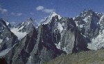
Much of mountaineer climb on the giant of Baltoro whereas not far,
the superb valley of Charakusa, Khridas, Nangma, Homboro and Kondus
is growing by isolated towers and superb granite spires which remain
out of the world. Charakusa valley opened only since 1984 and that its
access is strictly regulated cause of the militarized zone of very close
Siachen area, always disputed between India and Pakistan.
Exploration is still continuing, when spy satellites furrow the skies,
at the time where whoever can consult high quality satellite images
from home. Remember that the majority of incredible rock towers and
rised enormous pillars of the area were discovered by Westerners only
fifteen years ago. This page is devoted to the one of the greatest geographical
discovery of these last years, of these valleys which for some like
Homboro and Khridas were discovered 5 years ago! It's not only for political
reasons but only for geographical reasons (difficult access) and thanks
to mountaineers whom one could also describe as exploring adventurers.
We have choice to continue to furrow the trodden ways, or to leave it
! I invite you to do by consulting this web page.


|
|
Charakusa valley:
|
 There
are several other spectacular granite walls and spires at the eastern
end of the Charakusa Glacier, some of were ever climb but many are waiting
first climbers. Choice of climbs is incredible, the pretty mountainous
area, delicious camping sites and the very welcome people policy make
it a perfect climbing site for holidays. There
are several other spectacular granite walls and spires at the eastern
end of the Charakusa Glacier, some of were ever climb but many are waiting
first climbers. Choice of climbs is incredible, the pretty mountainous
area, delicious camping sites and the very welcome people policy make
it a perfect climbing site for holidays.
|
Kondus Valley :
|
 The
enormous Kondus glacier flows from the Conway and the group forming
by Saddle and Baltoro & Sia Kangri range. It was close for tourism
cause of near strategic area on Siachen glacier and a military route
was building. The
enormous Kondus glacier flows from the Conway and the group forming
by Saddle and Baltoro & Sia Kangri range. It was close for tourism
cause of near strategic area on Siachen glacier and a military route
was building.
|
Nangma valley :
|
 The
Nangma Valley is rapidly establishing itself as one the premier rock-climbing
venues in the Karakoram-Himalayan chain and several major new routes
were added last summer. Unfortunately, it is also reported that last
summer saw a huge mudslide wipe out Kande, the village at the entrance
to the valley from where all expeditions recruit their porters. The
Nangma Valley is rapidly establishing itself as one the premier rock-climbing
venues in the Karakoram-Himalayan chain and several major new routes
were added last summer. Unfortunately, it is also reported that last
summer saw a huge mudslide wipe out Kande, the village at the entrance
to the valley from where all expeditions recruit their porters.
|
Khridas & Homboro valleys:
|
 Khridas
Valley is the next north of the increasingly popular Nangma Valley in
the Hushe region. The Kahridas is a relatively narrow valley between
the Nangma and Charakusa with the fine pyramid of Drifika at the head..
It's nescessary to walk 2 days with little climb (5,9), that's why it
was discover very recently. Khridas
Valley is the next north of the increasingly popular Nangma Valley in
the Hushe region. The Kahridas is a relatively narrow valley between
the Nangma and Charakusa with the fine pyramid of Drifika at the head..
It's nescessary to walk 2 days with little climb (5,9), that's why it
was discover very recently.
Italian's team (Lanfranchi et Maspes) was first to explore Homboro valley
in 1999, North american team the was first to explore the Khridas valley
in 2000(Nils Davis, Sean Isaac et Todd Offenbacher). Khridas valley
become more and more popular.
|
Allah's Finger -5000m- (Vallée de Khridas)
:
|
It was first ascended in 1999 by Italians, Maurizio Giordani, Luca
Maspes and Natale Villa, with the Swiss, Lorenzo Lanfranchi. Climbing
to the top of the spire took four days and the 550m-high South Face
was graded VII+ obl and A2/A3. The North American trio of Nils Davis
(USA), Sean Isaac (Canada) and Todd Offenbacher (USA) made the first
ascent of a previously unnamed granite spire in the Khridas Valley,
the second team to explore this area.
|
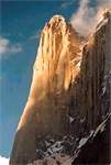
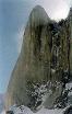
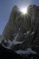
Amin Brakk -5850m- :
|
 Both
teams named the peaks after their respective cooks; Amin for the Spanish
(1995) and Nawaz for the British (1998). Both
teams named the peaks after their respective cooks; Amin for the Spanish
(1995) and Nawaz for the British (1998).
AminBrakk peak is one of the most spectacular of the earth and one of
the most popular in the Hushe area, one of the most difficult too (much
more of the Trango Towers), generally quoted as 5,850m but thought possibly
higher.
In 1996, the very experienced Spanish big wall climber, Jon Lazkano,
together with Adolfo Madinabeitia and Jose Carlos Tamayo made a capsule
style attempt on the 1,200m granite face of unclimbed Amin Brakk (c5,750m).
After 15 days on the wall the trio were forced to give up around 300m
below the top, worn down by bad weather, cold temperatures that caused
minor frostnip, and lack of food. They estimated another three to four
days of good climbable weather would be needed in order to reach the
summit.
Following on from their new routes on Beatrice in 1997, UK climbers
Steve Mayers, Louise Thomas and Mike 'Twid' Turner returned to the Hushe
region for some objectives they had reconnoitred after climbing Beatrice.
This year they were accompanied by Welsh climber Elfyn Jones, and Libby
Peter. Amin Brakk (often quoted as c5,750m but thought to be somewhat
higher) is a spectacular rock peak in the Nangma Valley south of the
Charakusa and is approached from the Hushe Valley south of the main
village. It has a much coveted c1,200m North Pillar which has been tried
at least twice in capsule style by Jon Lazkano and fellow Spanish climbers
via a line up the right flank. Their best effort reached within 300m
of the top and was filmed for the Spanish TV series On the Edge of the
Impossible. Jones, Mayers and Turner first inspected this line but realized
it probably wasn't practicable in the unsettled weather prevailing during
August. This turned out to be fortunate, as later a 200m lower section
of the pillar collapsed.
In 1998, while the Koreans were making their final attempt, the tried
and tested partnership of 37 years old Pep Masip and 28 years old Silvia
Vidal, together with 31 years old Miguel Puigdomenech, arrived at the
4,250m Base Camp to make their own attempt on Amin Brakk. Masip and
Vidal had scoped the West Face in 1998 while making the first ascent
of Brakk Zang opposite (see info). As the Spanish were acclimatizing,
the three Czechs arrived and established themselves on the lower pitches
of the Basque line. Finding their proposed project taken and increasingly
worried that this previously tried line was potentially exposed to rockfall
and avalanche, the three Spanish chose the big blank wall to the left,
closer to the prow. This was certainly much safer but offered no continuous
crack systems. After fixing five pitches, the trio set off in capsule
style, making four portaledge camps (the highest at c5,500m) and spending
30 continuous days on the wall before reaching the summit on the 6th
August. They hauled a total of 500kg of gear, which included food, fuel
and water (218 litres) for an estimated 28 days climbing. The rock was
mediocre with loose blocks on the initial section but, fortunately,
it then improved considerably. A total of 22 pitches were climbed, virtually
all of these 70m in length. Most of the route, christened Sol Solet
and 1,650m in length, required aid, with the eighth and 11th pitches
given A5, and the 13th an A4+ grade. The two A5 pitches were led by
the diminutive Vidal and took several days apiece, while the hardest
free climbing was the 6c+ sixth pitch led by Puigdomenech. The crux
eighth pitch followed an almost non-existent crack in the back of a
large, open, right-facing corner and required all sorts of sophisticated
techniques. Copperheads appear to have been very difficult to place
in the hard compact granite. Unfortunately, the 10th pitch proved exceptionally
blank and required 27 bolts in 70m. In addition, at least one bolt was
placed at each belay, though a hand drill was used at all times during
the ascent. The team note that out of the 32 days spent on the wall
(two days were needed to descend from the summit and completely strip
the route) only five were fine and sunny. On 19 it snowed and the remainder
were very variable For some time after the event (as confirmed by subsequent
reports in the Spanish press) the three were under the impression that
they had made the first ascent of Amin Brakk. On the 12th July, as the
Czechs were descending from the summit, the weather was very bad. As
he passed the Spanish portaledges some 250m to the side, Silhan was
able to shout across to a figure that he had succeeded. However, this
does not appear to have been understood and by the time the Spanish
arrived on the snowy summit, any tracks would have been obliterated.
|
Amin Brakk -5750m (5880m)-, face Ouest (vallée
de Nangma) :
|
 The
west face was reach the first toime by spanishs Jon Lazkano, Aldolfo
Madinabeita et José Carlos Tamayo. The
west face was reach the first toime by spanishs Jon Lazkano, Aldolfo
Madinabeita et José Carlos Tamayo.
|
Amin Brakk -5750m (5880m)-, voie Namkor (vallée
de Nangma) :
|
 "Namkor"
mean Bad weather in Balti language, christened after a hard climb
in the bad weather. "Namkor"
mean Bad weather in Balti language, christened after a hard climb
in the bad weather.
Adolfo Madinabeitia returned to the West Face of Amin Brakk (c5,850m)
last summer to create Namkor, a 1,550m line between the two routes completed
in 1999; Sol Solet to the left and Czech Express towards the right side
of the face. In 1996 Mandinabeitia had tried the face with fellow Spanish
climbers, Jon Lazkano and José Carlos Tamayo, climbing 1,100m
(25 pitches up to A3) in capsule style up the right side of the wall
before being forced to retreat in a bad storm. Lazkano had seen the
route the previous year while attempting the North West Face of neighbouring
Nawaz Brakk with Kike de Pablo and Josetxa Rodriguez. In 1999 Koreans
Bang Jung-Ho, Park Ihn-Soo and Hwang Young-Soon completed two further
pitches above the Spanish high point, then retreated leaving all their
ropes in place. Shortly after, Marek Holecek, Filip Silhan and David
Stastny from the Czech Republic completed the line to the top of the
wall at IX and A3, then climbed the remaining 300-400m of mixed ground
to the summit.
Last summer, Mandinabeitia and his partner, Juan Miranda, spent 10 days
acclimatizing, carrying loads and fixing around 11 pitches before committing
to the wall on the 5th July. On the 31st July they reached the summit
ridge (but did not continue the short distance to the highest point)
and arrived back on the Changma Glacier on the 4th August after 31 days
on the wall and 30 nights spent in portaledges. Only four of these days
were fine and sunny, the rest relatively poor or worse, resulting in
a total of 13 days lost to bad weather (Namkor is Balti for bad weather).
The new route has 31 pitches with approximately half free (up to 6b+)
and half aid. The crux section was undoubtedly the two 58m pitches 15
and 16, both graded A5. Above these pitches the route follows a left-
facing diedre and, finally, the face left of a large chimney system,
to arrive on the snowy crest close to the summit. Three portaledge camps
were established on the face and 50 bolts plus eight rivets used on
belays. Fifteen rivets were drilled and placed for progression. However,
much of the hard aid relied on a combination of birdbeaks and RURPS
in incipient cracks or difficult hooking on compact granite. Namkor
becomes the second route on Amin Brakk to be awarded the A5 rating.
|
Amin Brakk walls attempts :
|
* In 1995 : Spanish attemp (500m, F6b et A3).
* In 1996 : Basque attempt
* In 1998 : English attempt by Elfyn Jones/Steve Mayers/Mike/ Wid Turner
(1100m, 32 longueurs en E3 et A3).
* In 1999 : Success by Masip (37 ans), Silvia Vidal (28 ans) et Miguel
Puigdomenech (31 ans) (1650m, A5 et 6c+).
* In 1999, Coreans, Shin Dong-Chul, Jung-Ho et Hwang Young-Soon attempt
Amin Brakk, accomplished nearly the 1996 basque way (Success by Adolfo
Madinabeitia, Namkor way,see info). After their departure from the valley
the route was completed by the three Czechs, as reported in. In 1997
they were also part of the Korean team making the first ascent of the
Central Pillar on the West Face of Gasherbrum IV (Bang Jung-Ho reaching
the summit).
Soviet Valery Rozov climbed and based jumped from the summit (july
2004).
|
Baltistan Peak -c7,099m- :
|
Ce sommet est souvent apparenté au K6 mais c’est une erreur.
A la date de mise à jour de ce site, ce sommet semble être
vierge.
|
Barpoo Burakha (Prupoo Brakk) -c6,870m (c6,887m)
:
|
This summits was climbing by a japanese expedition (leader Hiroaki
Akiyama).
|
Beatrice Peak -c5,800m-, " Diaper couloir
" :
|
Beatrice is a c5,800m peak located on the north side of the Charakusa
Valley in the Hushe region. The summit ridge is a rather narrow complex
affair and has been reached once before by a young British team in 1988.
Andy Bunnage and Bob Marks made the first ascent of the peak via the
Diaper Couloir, a 1,000m D+ snow and ice gully on the south flank.
|
Beatrice Peak -c5,800m-, South face :
|
The first routes on this face were put up in 1997 when British climbers
Grant Farquar, Steve Meyers and Mike 'Twid Turner, and simultaneously
Glenda Huxter, Kath Pyke and Louise Thomas, climbed two roughly parallel
lines in capsule style; The Excellent Adventure (British E3 6a and A3+)
and Hateja (also British E3 6a and A3+). The three Americans chose a
line through the multiple overlaps to the right of the previous routes
and in rather inclement weather decided to fix ropes on the first 360m
before committing themselves to the wall. Once established on the route
they then had to face the worst storm of the expedition, which put down
approximately one metre of snow over several days. The trio fixed another
240m through discontinuous cracks on the headwall before deciding to
go for the top. However, when they discovered the summit to be guarded
by a long knife-edge ridge composed of poor snow and dangerously loose
blocks, Chin, Howe and Workman, in common with the two British parties
before them, decided that the top of the wall was reward enough. They
descended from this high point, christening their route Wanderlust and
offering a grade of VI, 5.10+, A3.
|
Beatrice Peak -c5,800m-, South Est face, "
The Excellent Adventure" & "Hajeta" routes :
|
The South East route on this face were put up in 1997 when British
climbers Grant Farquar, Steve Meyers and Mike 'Twid Turner, and simultaneously
Glenda Huxter, Kath Pyke and Louise Thomas, climbed two roughly parallel
lines in capsule style; " The Excellent Adventure " (British
E3 6a and A3+) and " Hateja " (also British E3 6a and A3+).
This is 2 long days climb on a difficult ridge, summit who nobody climb.
|
Changi Brakk (Changi tower) -c5,820m- :
|
An Australian/New Zealand party also made first ascents in the Nangma
Valley. The all-women's team of Abby Watkins, Vera Wong and Nicola Woodford
climbed Excess Baggage on the 5,300m Changi Tower. The route works left
up the main rock wall to climb a prominent crack system and snow slope
above to the main summit. Difficulties were rated at 5.10 and A2+. Watkins
and Wong currently hold the women's speed record for an ascent of the
Nose on El Capitan (16 hours and 40 minutes).
New Zealanders, New Norton and Paul Weber, also climbed a route on the
Changi Tower, starting to the left of Excess Baggage up a slanting corner
system then cutting through the last named route to finish on the North
Summit. The climb was completed in 10 days at 5.10 and A1, involved
26 pitches and was christened " Just a Quickie " as the pair
had originally thought it would provide a quick warm-up climb before
heading off for greater things.
|
Changi Brakk (Changi tower) -c5,820m-, East face
:
|
In 1998 the East Face was climbed by two routes: " Just a Quickie
" (Norton/Weber: 5.10+ and A0) to the North Summit (c5,800m) and
Excess Baggage (Watkins/Wong/Woolford: 5.10+ and A2+) to the main summit
(c5,820m).
Rubén Aramendia, Fermin Izco and Mikel Zabalza, compatriots of
the Spanish team on Amin Brakk, set up Base Camp on the 26th June at
4,300m, further up the Nangma Valley from the glacier branch leading
to Amin Brakk. From there they then tackled a line on the East Face
of the multi-summited and somewhat complex c5,820m Changi Tower.
|
Charakusa Tower -c5,600/c5,400m- (Khridas valley):
|
We suppose that the high of this mountain is 200 meters lower as khown
on maps. Not many informations about this mountain.
|
To the same topics:
|
|
Revision A - 24/06/06 (http://blankonthemap.free.fr)

|

