|
|
|
|
Here joints maps of the area :
|
|
|
|
|
|
|
|
|
|
|
|
|
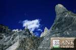
Unnamed Big Walls -~c6,000m-:
|
  A
big wall is 1000m of high rock spur is a minimum 80° steep. These
spurs have a semi-official name: Hassan Peak or Gum peaks. It's approximatively
1500 meters high. A
big wall is 1000m of high rock spur is a minimum 80° steep. These
spurs have a semi-official name: Hassan Peak or Gum peaks. It's approximatively
1500 meters high.
|
Hispar pass -c5,151m-:
|
|
 On
left bank of Hispar glacier, the pass was always difficult and dangerous:
the Hispar glacier is crevassed, and the upstream reservoir of Biafo
too vast. In the medium of XIXième century, a band of plunderers
lost themself in a storm between Nagar and Askole. On
left bank of Hispar glacier, the pass was always difficult and dangerous:
the Hispar glacier is crevassed, and the upstream reservoir of Biafo
too vast. In the medium of XIXième century, a band of plunderers
lost themself in a storm between Nagar and Askole.
|
Sokha pass (Sokha La):
|
 The
existence of a glacier without emissary on the other side of Sokha pass
had been constant with insistence by Fanny Bullock-Workman against W.M.Conway.
H.W.Tilman, disillusioned, finished the myth in 1937 when he crossed
the pass and walked on the glacier and, two days later, bathed in the
hot and sulfurous springs of Bisil in the Basha valley. The
existence of a glacier without emissary on the other side of Sokha pass
had been constant with insistence by Fanny Bullock-Workman against W.M.Conway.
H.W.Tilman, disillusioned, finished the myth in 1937 when he crossed
the pass and walked on the glacier and, two days later, bathed in the
hot and sulfurous springs of Bisil in the Basha valley.
|
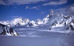
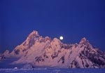
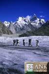
Biafo & Hispar glaciers :
|
  Respectively
58 and 68 kms long, Biafo & Hispar glaciers cut an big way in the
heart of central Karakoram and constitutes one of the longest extent
icy place out of the polar areas. H.Godwin Austen map the Shigar glaciers
in 1861 and went up Biafo glacier but this super glacial motorway remained
largely ignored before the arrival of Martin Conway 31 years later.
Conway was the first to cross Hispar pass the 18th of July 1892. This
mission and the description of the places attracted the Workman Bullock
which remain forever associated with the first explorations of this
area. Biafo and Hispar were attended for a long time by Askole and Nagar
local people: they however imposed 120 kilometers of hard walk on the
glacier, complicated, painful and dangerous. Until the middle of the
last century, Nagaris and Hunzakuts people have to cross Nushiq La,
the western pass from Hispar to Arandu and down the valley of Basha
towards Shigar, Skardu and beyond. Baintha Brakk dominates, one of the
great bivouacs to the left bank called Baintha (Brakk means in Balti
" the rock mountain"). The glacier of Biafo is moving at the
200m speed per year. The Hispar glacier run down the foot of a the highest
group of mountains in Asia, the Hispar Range. Its movements of rise
and erosion be the more active of world. Respectively
58 and 68 kms long, Biafo & Hispar glaciers cut an big way in the
heart of central Karakoram and constitutes one of the longest extent
icy place out of the polar areas. H.Godwin Austen map the Shigar glaciers
in 1861 and went up Biafo glacier but this super glacial motorway remained
largely ignored before the arrival of Martin Conway 31 years later.
Conway was the first to cross Hispar pass the 18th of July 1892. This
mission and the description of the places attracted the Workman Bullock
which remain forever associated with the first explorations of this
area. Biafo and Hispar were attended for a long time by Askole and Nagar
local people: they however imposed 120 kilometers of hard walk on the
glacier, complicated, painful and dangerous. Until the middle of the
last century, Nagaris and Hunzakuts people have to cross Nushiq La,
the western pass from Hispar to Arandu and down the valley of Basha
towards Shigar, Skardu and beyond. Baintha Brakk dominates, one of the
great bivouacs to the left bank called Baintha (Brakk means in Balti
" the rock mountain"). The glacier of Biafo is moving at the
200m speed per year. The Hispar glacier run down the foot of a the highest
group of mountains in Asia, the Hispar Range. Its movements of rise
and erosion be the more active of world.
The first ski crossing of the Karakoram range over Hispar pass was made
by G.Rowell from Panamik (Nubra) to Gilgit (Hunza).


|
Solu & Sokha glaciers :
|
A small and primarily female group of British mountaineers planned
to spend the second half of July 2000 exploring the Hucho Alchori Glacier
north of Arandu. Base Camp was reached but as a result of the previous
lean winter and almost continuous rain while they were in the region,
feasible lines on accessible peaks were incomplete and threatened either
by stonefall or avalanche. No climbs were completed but the team did
find evidence of a camp, which they surmise must have originated from
the Bullock- Workman expedition in the early 1900s. This glacier system
was also visited in 1959 by Tony Streather's British Army expedition,
which climbed a peak (provisionally named Gloster Peak) on the Hispar
watershed.
Dave Wilkinson returned to old haunts last summer with a visit to the
Arandu (see redakh Brakk, Shek Chakpa Basha River) Valley in the company
of fellow British mountaineers, Bill Church, Gus Morton and Stewart
Muir. The objective this time was a fine, pointed snow peak of c5,800m
towards the head of the valley that rises east from the village of Zil
towards the flanks of the Ganchen Massif.
Dave Wilkinson continued his exploration of the largely unknown glacier
basins accessed from the Arandu Valley with a small expedition to the
Solu Glacier immediately south of the Hispar. With fellow British climbers
Ken Findlay, Paul Hudson and Karl Zientek, Wilkinson established Base
Camp on the 22nd July at c3,850m a little way above the herdsmen's encampment
of Sugulu and three days' march from the jeep road at Bizil. Although
briefly visited and mapped during Shipton's 1939 expedition, there were
no known reports of previous mountaineering activities from the Solu
Glacier. However, en route to Base Camp the British party heard from
locals that an expedition had visited the valley several years before
and climbed peaks from the glacier basin west of Singulu, Unfortunately,
information on who they were and exactly where they went was extremely
sketchy.
|
Snow Lake (Lukpe Lawo/Lukpe Balto) -c5,000m-:
|
 The
highest section of the Biafo glacier is create by two other glaciers,
almost flat: Lukpe Lawo, in the North and Sim Gang, the East. Martin
Conway christened this vast snow-covered place which it discovered from
Hispar pass "Snow Lake". It's 45 km2 makes a very impressive
Arctic there. In 1937 B Tilman with his faithful E Shipton noticed the
traces steps of possible yeti. They were approximately 20 centimeters
wide and were spaced by about 50 centimetres, were round without trace
of foot or of heel, 3 or 4 days old and were steep approximately 30
centimeters. Baltis porters affirmed that it was the smallest yeti,
which eat human, the other nourishing rather yaks. Tilman perhaps was
unaware of that these steps could come from bears steps which there
remains only in the North of the Biafo and Hispar glaciers, on the Panmah
glacier and around. It is possible to see vultures, ibexs and bharals
on the accesses of the Biafo and Hispar glaciers, a little downwards.
Baltis name of this Arctic place is "Lukpe Lawo" or "Lukpe
Balto". Snow Lake, far from the crowded Baltoro is very wild, expeditions
are still rare to see, even the less intrepid trekkers, when he sit
down to admire sunset at Baintha camp or on the bank of Snow Lake, it
can feel as a a true worthy follower of Conway, Shipton, Bullock or
Duke of Abruzzi. The
highest section of the Biafo glacier is create by two other glaciers,
almost flat: Lukpe Lawo, in the North and Sim Gang, the East. Martin
Conway christened this vast snow-covered place which it discovered from
Hispar pass "Snow Lake". It's 45 km2 makes a very impressive
Arctic there. In 1937 B Tilman with his faithful E Shipton noticed the
traces steps of possible yeti. They were approximately 20 centimeters
wide and were spaced by about 50 centimetres, were round without trace
of foot or of heel, 3 or 4 days old and were steep approximately 30
centimeters. Baltis porters affirmed that it was the smallest yeti,
which eat human, the other nourishing rather yaks. Tilman perhaps was
unaware of that these steps could come from bears steps which there
remains only in the North of the Biafo and Hispar glaciers, on the Panmah
glacier and around. It is possible to see vultures, ibexs and bharals
on the accesses of the Biafo and Hispar glaciers, a little downwards.
Baltis name of this Arctic place is "Lukpe Lawo" or "Lukpe
Balto". Snow Lake, far from the crowded Baltoro is very wild, expeditions
are still rare to see, even the less intrepid trekkers, when he sit
down to admire sunset at Baintha camp or on the bank of Snow Lake, it
can feel as a a true worthy follower of Conway, Shipton, Bullock or
Duke of Abruzzi.
From the Snow Lake, we can see the fully majesty of the Northern Baintha
Brakk (7285m), one of the major problems of Karakoram. The Bobisgir
(6416m) close the North-western angle of the Panmah range (Panmah which
means "the arc shooting", in reference to its characteristic
form).
|
|
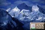
Unnamed summits -~c6,000m-:
|
 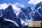  There
is still innumerable mountains without name in the area and whose summits
remains still virgins. These summits separating the glacier of Biafo
and Hoh Lungma valley in the South-East Sosbun Brakk : they do not reach
6000m, the rock is generally poor, but they are very impressive, powerful
attraction of the unknown of virgin summits in a secret area. There
is still innumerable mountains without name in the area and whose summits
remains still virgins. These summits separating the glacier of Biafo
and Hoh Lungma valley in the South-East Sosbun Brakk : they do not reach
6000m, the rock is generally poor, but they are very impressive, powerful
attraction of the unknown of virgin summits in a secret area.
|
|
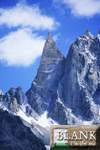
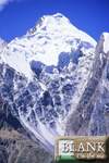
Baintha group (Ogre's group) -c6960m/c7,285m-
:
|
 Up
to the beginning of 2001 almost 20 expeditions, many involving world-class
mountaineers, had tried the Ogre by various routes, most concentrating
on either the elegant South or South East Pillars. Few had come within
300m of the summit and no one other than the first ascensionists had
managed to stand on the highest point. Up
to the beginning of 2001 almost 20 expeditions, many involving world-class
mountaineers, had tried the Ogre by various routes, most concentrating
on either the elegant South or South East Pillars. Few had come within
300m of the summit and no one other than the first ascensionists had
managed to stand on the highest point.
In year 2001, four expeditions attempted 7285m Baintha Brakk last summer
and although talented groups from America, Austria and Slovenia all
failed, a three-man Swiss-German team achieved the highly coveted second
ascent of the peak after an interval of 24 years. Although no new ground
was climbed, their success was arguably the most notable mountaineering
achievement during the entire 2001 season.
|
Baintha Brakk I (Ogre I) -c7,285m-, south face
:
|
 Four
attempts had already been made on the formidable Ogre, the highest mountain
in the Biafo Glacier region, when Doug Scott gained a permit for 1977.
The assault was initially a two-pronged affair, with Paul 'Tut' Braithwaite
and Scott aiming for an Alpine style ascent of the elegant rock prow
forming the South Pillar, while Mo Anthoine, Chris Bonington, Nick Estcourt
and Clive Rowland concentrated on a more conventional fixed roped ascent
of the Southwest Face. After climbing a relatively safe icy rib through
the avalanche threatened Southwest Face, Bonington and Estcourt took
off for a very bold attempt at the lengthy traverse towards the Main
Summit. Four days later they returned unsuccessful, though as a consolation
they had managed to bag the lower West Top. Four
attempts had already been made on the formidable Ogre, the highest mountain
in the Biafo Glacier region, when Doug Scott gained a permit for 1977.
The assault was initially a two-pronged affair, with Paul 'Tut' Braithwaite
and Scott aiming for an Alpine style ascent of the elegant rock prow
forming the South Pillar, while Mo Anthoine, Chris Bonington, Nick Estcourt
and Clive Rowland concentrated on a more conventional fixed roped ascent
of the Southwest Face. After climbing a relatively safe icy rib through
the avalanche threatened Southwest Face, Bonington and Estcourt took
off for a very bold attempt at the lengthy traverse towards the Main
Summit. Four days later they returned unsuccessful, though as a consolation
they had managed to bag the lower West Top.
An injury to Braithwaite put the South Pillar out of the question, so
after all team members had retired to base to lick their wounds, Scott
joined Antoine, Bonington and Rowland for a traverse over the West Top
and along the connecting ridge towards the Main Summit. On the 13th
July, from a snowhole at c7000m, Bonington and Scott set out for the
summit in a lightweight bid without bivouac equipment.
Tricky climbing led to the final tower, which was nearly vertical granite
for over 100m. The long second pitch involved very demanding free and
aid climbing (VI and A2) and included a giant pendulum movement at half-height
to gain a second crack system. Above, several more hard pitches led
to the summit, which the pair reached just before dusk. Subsequent events
would probably overshadow what was possibly the hardest technical climbing
achieved above 7200m at the time.
Not long after, while attempting to make a diagonal rappel from just
below the top, Scott slipped and made a huge involuntary pendulum across
the wall, slamming into a rocky corner on the far side and badly breaking
both ankles. From now on the descent would be a fight for survival,
or as Scott reflected, 'so that's how it was going to be; a whole new
game with new restrictions on winning'.
After a night out in the open with no equipment, the two continued rappelling
and were eventually met by Antoine and Rowland, who escorted them back
to the snowcave, Scott on hands and knees. The four were then trapped
for more than 24 hours in a fierce blizzard, after which, with no food
remaining, Rowland made a superb effort, leading the team through atrocious
weather over the West Summit and down to a second, much poorer, snowcave.
The next day the storm was, if anything, worse but the three fit climbers
battled down, escorting a sliding or crawling Scott towards two flattened
tents left at the West Col. If things weren't already bad enough, they
Suddenly took a turn for the worse after Bonington fell, breaking two
ribs and badly damaging his hand. It was now left to Antoine and Rowland
to get the party off the mountain before it became too late. Four days
later, when Scott finally crawled over the moraine above Base Camp,
his clothing torn to shreds, his knees raw and bloody, Braithwaite and
Estcourt had already left, having given up the party for dead. Scott
was subsequently carried for three days by local porters to the nearest
village, where a helicopter was able to evacuate him. However, a bad
landing put the aircraft out of action and Bonington was forced to wait
another week before he could be flown to safety. The 1977 ascent has
undoubtedly become one of the highlights of British mountaineering but
only confirms that when operating at the highest levels, climbers often
tread a very fine line (the line of the first ascent of The Ogre (7285m)
by Bonington and Scott in July 1977 was repeated for the first time
by the German-Swiss trio of Huber, Stöcker and Wolf in June 2001).
In 1996, Shigeru Nagasawa and his five Japanese compatriots from the
Kanagawa Himalayan Club were hoping to make the second ascent of the
original 1978 British Route on Baintha Brakk (The Ogre) but gave up
in August. The individual ages of team members spread from a mere 19
to 56. They were apparently planning to fix up to 3,000m of rope on
the mountain.
During summer 1997, The 7,285m Ogre had two more unsuccessful attempts
on its flanks during the summer. Twenty five years old Jan Mersch and
28 years old Jochen Hasse, who were part of the German group on Latok
II, retreated at around 6,250m from the frequently tried South Pillar.
The pillar itself (25 pitches up to VII and A1 ending at about 6,400m)
was first completed in 1983 by the French, Fauquet and Fine, who retreated
from a height of almost 7,000m on the 50 snow slopes below the final
rock dome of the Ogre. Hasse had reached a little higher on the same
line in 1993.
Shigeru Nagasawa and his five Japanese compatriots from the Kanagawa
Himalayan Club were hoping to make the second ascent of the original
1978 British Route on Baintha Brakk (The Ogre) but gave up in August.
The individual ages of team members spread from a mere 19 to 56. They
were apparently planning to fix up to 3,000m of rope on the mountain.
In 2001, prior to this activity a two-man Italian team of Alois Brugger
and Hans Kammerlander was at Base Camp, planning an Alpine style ascent
of the Original British Route before Kammerlander moved on to attempt
a ski descent of K2. The pair were on the mountain in early June, having
established an Advanced Base below the face at 5,000m. Their best shot
took them to 6,200m but the weather was unsettled and the route threatened
by snow and serac avalanche. They retreated from their high point (below
the plateau) on the 21st. A second foray up to Advanced Base on the
24th showed more than half-a-metre of fresh snow lying as low as 5,000m
and with time running out, the pair reluctantly decided to dismantle
the tent and abandon any further attempts, departing Base Camp the following
day.
|
Baintha Brakk I (Ogre I) -c7,285m-, South pillar
:
|
 The
South Pillar was first climbed to the upper snowfields in 1983 by the
French, Michel Fauquet and Vincent Fine. This pair continued up towards
the summit, reaching an altitude of 7000m (a height that until last
year had never been equalled on this line) before bad weather forced
them down. The 6,400m top of the South Pillar had been reached three
times since, in 1990, '95 and 97 and some near misses achieved in other
years, but only the Germans, Lentrodt and Wittmann, in 1990 appear to
have continued above with a serious attempt on the summit. After some
aid low down on the crest (A2) the pillar gives free climbing with difficulties
variously rated from 6a/6b to 7a depending on the quantity of aid used.
The well-known Huber brothers from Germany tried the route in 1999,
failing to get above 6,000m but reportedly climbing the pillar free
to that point. The
South Pillar was first climbed to the upper snowfields in 1983 by the
French, Michel Fauquet and Vincent Fine. This pair continued up towards
the summit, reaching an altitude of 7000m (a height that until last
year had never been equalled on this line) before bad weather forced
them down. The 6,400m top of the South Pillar had been reached three
times since, in 1990, '95 and 97 and some near misses achieved in other
years, but only the Germans, Lentrodt and Wittmann, in 1990 appear to
have continued above with a serious attempt on the summit. After some
aid low down on the crest (A2) the pillar gives free climbing with difficulties
variously rated from 6a/6b to 7a depending on the quantity of aid used.
The well-known Huber brothers from Germany tried the route in 1999,
failing to get above 6,000m but reportedly climbing the pillar free
to that point.
|
Baintha Brakk I (Ogre I) -c7,285m-, Southwest
face :
|
In year 2002, Japanese mountaineers almost succeeded in a new and
dangerous route up the South Face but after a bold push on the upper
slopes, they were thwarted within a handshake of the top, unable to
climb the final 10-15m to the highest point. Since then the Southwest
Face has become much more dangerous due to serac activity and, therefore,
rarely attempted.
|
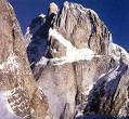
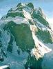
Baintha Brakk I (l'Ogre) -c7,285m-, North face
:
|
 These
big North face that we can see well from the Snow Lake is stil a big
problem for climbers (still virgin). These
big North face that we can see well from the Snow Lake is stil a big
problem for climbers (still virgin).
|
Baintha Brakk I (Ogre I) -c7,285m-, East summit
(c7,150m) :
|
 This
is a route that has been attempted on numerous occasions from the Choktoi
Glacier, the best effort coming in 1991 from the Americans Mike Colombo,
Tom Nonis, Steve Potter, Mimi Stone and Brinton Young, who climbed the
initial rock pillar at 5.9 and two points of aid, then reached a point
c30m below the East Summit before being forced down by a bad storm,
which subsequently continued for six days. The route has an objectively
dangerous approach to the c5,650m col at its base but once on the pillar
the climbing is relatively safe and on sound granite to a large snowfield
at around half-height. Above, lies more snow, ice and finally difficult
mixed climbing on the south flank. This
is a route that has been attempted on numerous occasions from the Choktoi
Glacier, the best effort coming in 1991 from the Americans Mike Colombo,
Tom Nonis, Steve Potter, Mimi Stone and Brinton Young, who climbed the
initial rock pillar at 5.9 and two points of aid, then reached a point
c30m below the East Summit before being forced down by a bad storm,
which subsequently continued for six days. The route has an objectively
dangerous approach to the c5,650m col at its base but once on the pillar
the climbing is relatively safe and on sound granite to a large snowfield
at around half-height. Above, lies more snow, ice and finally difficult
mixed climbing on the south flank.
In 2001, a very strong four-man Slovenian team, comprising Urban Azman,
Tomaz Jakofcic, Silvo Karo and Peter Meznar, attempted the unclimbed
South East Pillar leading to the virgin East Summit (7150m). The Slovenians
arrived at the 4,600m Base Camp in the middle of June and spent the
next month attempting the pillar. They managed to climb the difficult
700m rock section above the col and reached a high point of c6,350m
at the base of the large snow field but very bad weather drove them
down.
|
Baintha Brakk I (Ogre I) -c7,285m-, South-East
ridge :
|
 The
South East Ridge of the Ogre leading to its unclimbed East Summit has
been attempted on a number of occasions by various nationalities, with
perhaps the best effort coming from the American team of Buhler, Crecelius
and MacMillan in 1993 : The
South East Ridge of the Ogre leading to its unclimbed East Summit has
been attempted on a number of occasions by various nationalities, with
perhaps the best effort coming from the American team of Buhler, Crecelius
and MacMillan in 1993 :
With MacNae out of action from the first week due to an unfortunate
altercation with a crevasse, Richard Cross, Matt Dickinson, Adam Jackson,
Al Powell, Nick Williams and Julian Wood made steady progress in climbing
the icefall above the Choktoi Glacier to the col at c5,650m and fixing
some of the rock buttress above. The icefall proved particularly difficult
and serious. Due to a food shortage caused by raiding ravens, most of
the team dropped down to Base Camp on the 7th August, leaving Dickinson
and Powell to spend the next four days completing the c700m buttress
(British E1 and A2), leaving the difficult sections fixed (thanks to
a large cache of new rope abandoned by a previous expedition). On the
12th, as the rest of the team started up from Base Camp, the pair made
a summit attempt from the 5,650m col and reached the foot of the final
gully (c6,900m) two days later. Above the buttress they followed the
diagonal snow ramps and climbed tricky mixed terrain (some Scottish
VI) to reach this high point perhaps only one day away from the summit.
The gully above looked hard, though certainly feasible but the arrival
of a big storm prevented any attempt. The pair sat out two days at their
top bivouac before being forced down due to lack of provisions. Two
metres of snow fell during the next week and Powell plus Jackson decided
to head for home. The rest stayed at the col hoping for an improvement
but eventually decided to abandon any further climbing on the 26th.
They spent the next three days stripping the route of tentage and fixed
rope including a significant amount of gear left by the previous expeditions.
The last four members reached Base Camp on the 29th, with Dickinson
having spent a remarkable 28 continuous days on the route at or above
the col.
|
Baintha Brakk II (Ogre II) -6800m-:
|
In 1981, a three-man Japanese team comprising Noritoshi Isayama, Taihei
Kato and Yukio Toji, attempted the South East Pillar. This 800m very
steep narrow rock ridge was reached by a 1,000m long icy couloir on
the South Flank. It leads to the West Summit, from which the Japanese
planned a lengthy traverse of the connecting ridge to the Main Top.
Climbing on the pillar in rock boots, they reached c6,400m before retreating.
In 1982, it was the turn of British climbers, Brian Hall, Paul Nunn,
Andy Parkin and Al Rouse. They made several attempts on the still unclimbed
Ogre II, one of which followed the Japanese attempt. However, just above
the exit to the icy gully, Nunn's crampon disintegrated the team retreated.
In 1983, Koreans Han-Gyu & K.Dug-Yong reach the difficult summit
of Baintha Brakk II (c6,960m), exposed to icefull dangers coming from
the 2 sides of the glacier before the big face (Bowling Alley).
In august 1994, Alexander Huber in a german climbing expedition (leader
Mersh) attempt the North ridge down the Ogre II, reaching 6,600m.
The ridge appears to have remained untouched until 2000 when an attempt
by Maurizio Giordani's five-member team of accomplished Italian rock-climbers
was defeated by a combination of high technical difficulties, lack of
time and bad weather. The Italians fixed the approach couloir, placing
15 bolt anchors for rappel. They felt the climb to be very serious and
technically difficult, providing a challenging objective to future parties.
|
Baintha Brakk II (Ogre II) -c6,960m-, "Death
Alley" route:
|
The approached used by the 1978 Japanese attempt on the Ogre and by
the British who attempted Ogre II in 1982 and by the Koreans who eventually
climbed the latter in 1983.
|
Baintha Brakk III (Ogre III) -c6,960m- :
|
Maurizio Giordani's five-member team of high standard Italian rock-climbers
was defeated by a combination of high technical difficulties, lack of
time and bad weather on the South East Ridge of what they refer to as
the unclimbed Ogre III. This is the name given by the Italians to the
West Summit of Ogre II (6,960m), which in their opinion is a distinct
top separated by two or three days' climbing from the Main or Central
Summit ascended in 1983 from the northwest by a Korean expedition. The
South East Ridge had previously been attempted in 1981 by a three-man
Japanese team, that climbed an icy gully on the South Face to reach
the steep upper buttress of the ridge. Climbing in rock boots on the
upper pillar they reached c6,400m before retreating.
The following year it was the turn of British climbers, Brian Hall,
Paul Nunn, Andy Parkin and Al Rouse. They made several attempts on the
then unclimbed Ogre II, one of which followed the Japanese attempt.
However, just above the exit to the icy gully, Nunn's crampon disintegrated
and the team retreated.
Arriving at their 4,400m Base Camp on the Uzun Brakk Glacier in June,
the Italian team acclimatized and by the 17th had fixed 1,000m of rope
up the approach couloir to a col at the start of the steep rocky section.
They found ancient fixed rope and garbage from the Japanese attempt
but it is unclear whether they climbed the same gully system or one
further to the right. The upper 800m+ pillar is very steep and appears
to have a difficult final rock band barring access to the summit slopes.
Maurizio Girardi and Emanuele Pellizzari reached a similar high point
to the Japanese in 1981 before forced down in a storm. They removed
all their equipment from the mountain except for 15 rappel anchors (each
a single bolt plus karabiner) in the gully. Later this same pair attempted
a new route on the nearby Ogre's Thumb but retreated after five pitches
(VII maximum) in a snowstorm. The expedition cleaned the lower glacier
of all sorts of rubbish, from abandoned wrapping to shovels and tents,
then hired two extra porters to take it all back to Skardu. The South
East Ridge of Ogre III is a very serious and technically difficult climb,
which will prove a challenging objective to future parties.
In 2000, 34 years old Thomas Huber was back, this time with his partner
from the successful new route on Shivling, Iwan Wolf (aged 28), and
fellow Swiss, Urs Stöcker (aged 24). The team arrived at Base Camp
(4,500m) on the 7th June to find three Americans, Hans Johnstone, photographer
Ace Kvale, and Mark Newcomb, already at work on the South Pillar. The
atmosphere appears to have been less than cordial and deciding that
both teams could not work in harmony on the route, Huber and friends
decided to concentrate on the unclimbed Ogre III, for which they also
had permission. Their successful ascent, in itself a very major achievement,
is reported below.
On the 30th June, as the Swiss-German team was making its summit push
on Ogre III, Johnstone and Newcomb, reached the top of the South Pillar
(fifth ascent) and bivouacked. On the 1st July they headed up and across
the large snow/icefield towards the summit tower but were caught in
a snowstorm and retreated. They descended to Base Camp and then left
for home. This gave the Swiss-German team a second chance. After a suitable
rest the three left their 5,000m Advanced Base (Camp 1) on the 8th July,
climbed the 300m couloir to the notch on the pillar crest (which they
found more dangerous from stonefall than on previous occasions) and
fixed 10 pitches, including the crux, which Huber, now well-acclimatized,
was able to redpoint at VIII+. Next day Stöcker and Wolf fixed
rope to the proposed site of Camp 2 at 5,900m, where they established
a portaledge. A bad storm now moved in, the climbers retreated and subsequently
were unable to regain the portaledge until the 18th. On the 19th Huber,
Stöcker and Wolf climbed eight more pitches and established the
portaledge (Camp 3) at 6,200m. The following day they reached the top
of the pillar in five more slabby pitches and then climbed the icy crest
above to make Camp 4 (a bivouac under the portaledge fly) at c6,500m.
To the end of the rock section they had climbed 26 roped pitches. A
2am start on the 21st saw the three climbers ascending rightwards across
the giant snow/ice field, reaching its apex at 8.30am. In strengthening
winds they tackled the summit buttress, following the line taken in
1977 by Bonington and Scott. Difficult mixed ground led to the three
hard rock pitches, on which the Alpinists discovered old pegs and confirmed
the grade as VI and A2, with a long and tricky pendulum. Huber was impressed
by the climbing, which although by today's standards would not be considered
very hard, took place in parallel sided cracks eminently suitable for
Friends which, of course, were not available to the original ascensionists.
The three reached the highest point at 3.30am and on the following day
rappeled 800m down the South Pillar to arrive safely back on the glacier
by mid-afternoon.
|
To the same topics:
|
|
Révision A - 23/12/06 (http://blankonthemap.free.fr)

|

