|
|
THE
CONFLICT OF KASHMIR
- page 3/3 -
|
|
|
|
|
|
|

|
|
Geopolitics mistakes wich were the origin of the
conflict of Kashmir:
|
The causes of the conflict of Kashmir were many, which you will be
able to see at the end of this document - the access to the specific
and better documented sites. This Web site proposes a thought of the
particular topography of Kashmir and which were, at the time, the root
of the conflict of Kashmir. 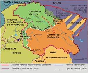
Geography is a means of knowledge which also takes into account the
heights of the mountains, the lengths of rivers, etc. the social and
economic situation of the time, so that it basically, meets a fundamental
need which allows to act on the ground. Geography makes use of this
information and it’s, more or less high degree of accuracy, enables
the people to have an important advantage in a conflict. To behold the
geographic keys is to have the base of geopolitics and the military
strategy. The punishment of a geographical ignorance is inevitably war.
The particular topography of Kashmir, extremely mountainous, had unevitable
consequences on the problems of an already complicated partition.
At the time of the partition, the principal economic situation of Kashmir
was forgotten because it was less necessary to seek the richness in
its earth, rather than in the immense and unexpected richness that the
mountains can offer - thus water was the forgotten element of the partition.
By declaring that Kashmir was “the jugular vein of Pakistan”
Jinnah underlined a geographic fact of considerable strategic importance.
In these areas, water is not only “necessary” to life, it
is “life itself” and this expression becomes very important
especially at this latitude which is equal to the deserts of Baloutchistan,
the Rajasthan and Takla makham, where the rainfall is even less than
in the Sahara. The partition of 1947 deprived Pakistan of its river
sources of Penjab of Jelhum, Chenab, the delighted one, Beas and Sutlej
- rivers which gave birth to the name of the Penjab province. These
five river, the sources are in Kashmir, are vital for the economy of
the country. The Indus basin in which the majority of the Pakistani
population lives, concentrates all the richness of the country and it
is supplied by water of various rivers and their affluents. This richness,
as well as the formidable icecap of the northern areas, comes from one
and the same origin, Kashmir. Without speaking about the sacred character
of the Indus river, to conquer these highlands, would allow Pakistan
to control the whole Indus flow whose source can be found on the annexed
Tibetain grounds of the Chinese ally.
 The problem of the Kashmir is in his heart : the beautifulle and
rich valley, the indian's Switzerland.
The problem of the Kashmir is in his heart : the beautifulle and
rich valley, the indian's Switzerland.
The speed by which the partition was set up as well as the geographical
ignorance of North Kashmir at that time in the middle of the last century,
probably was of great importance in the conflict of Kashmir which opposed
India, China and Pakistan. On August 15, 1947, date of the partition,
the geography was not better known than in 1937, when Shipton wrote
his book “Blank on the map” the title describes the sorry
character of these forgotten Arctic areas by humans. The layout of the
borders between India and Pakistan, at the time of the partition, was
decided upon by a special commission between the 21st and the 24th of
July 1947 in only 11 days. These 11 days were not long enough for the
commission to decide on the Kashmir borders, whose geography was, in
many cases, always vague or even unknown. The considerable amount of
information reported by the Survey of India, followed by explorations
of Goldwin Austen, Conway of Baltoro, Shipton in the areas of Panmah,
Shaksgam and Biafo, the Bullock couple in the areas of Hispar and Siachen,
were all ignored. The first existance of Kashmir is the probable consequence
of this ignorance.
In 1962, the area of Aksin Shin, remote aand backwards, was added
to India for the same reasons. This negligent Indian strategy, which
lead to the loss of their territory, because, at first sight, it seemed
without economic value, will have serious consequences to the conflict
of Kashmir especially regarding the credibility of the Indian military
forces.The origin of the second Pakistani Indo war and the acceleration
of the nuclearisation of the conflict of Kashmir. Lastly, during the
crisis of Kargil in 1999, India had much trouble to get rid of the Pakistani
forces as well as the infiltrated Kashmiries, because, with their excellent
knowledge of their homeland and good resistance to altitude, they held
an advantage over the Indian military. These exemples particulary show
up to what point geographic knowledge is of major importance when war
is at stake.This had unquestionable consequences on the conflict of
Kashmir especially in this part of the world where ground is very difficult.
Geographical science, when shared with the art of war, is in the interest
to control territory. The obvious link between geography and war is
the cartography. Already in the 19th century, the British Raj, wanting
to affirm his domination in Asia, trusted the British officers who travelled
the remote mountains and back are as of the north, with the cartography
of the Indian sub continent and its borders. They were long, difficult
and perilous missions. Sir Godwin Austen, as well as George Everest
were Survey Officers of India. They devoted their lives to writing pages
of figures, going through cold and inhospitable places, sometimes disguised
as natives, sometimes illness took over, but they always continued to
add their contribution to this enormous task, the establishment of a
detailed chart of the sub continent. From the south of India in 1808,
the great Survey Officers progressed step by step. The Everest (Peak
XV) was only identified in 1848 and K2 in 1856, after half a century
of exploration.
In the 19th centuary, all of the sheltered kingdoms of the Himalayas
were prohibited, for eg, Tibet, Nepal, Bhutan and Sikkim as well as
Kashmir. One can measure the exclusiveness of these regions and the
difficulty of going through their mysteries by reading “Voyage
in Tibet” written by Alexandra David Neel and also “Annapurna,
first 8000” where Herzog was the first one of the Westerners to
open the doors of Kathmandu in 1950. The high, remote back valley of
Kashmir, which have a more septtentrional climate than the Himalayas
in the South and are closed by snow during the winter, are separated
by unclimable mountains. They sheltered various populations who lead
a self-sufficient life and were not very open to dialogues. The rulers
and the kings of these high valleys made war from one valley to another.
The tradition of armed robbery damaged their reputation and brought
misfortune to the travellers who went to these high valleys. Karakorum
meant “ the black mountains”, which refers less to their colour
than to the danger of the paths that the merchants of the silk road
were obliged to use. These rulers and heads of tribes kept and strongly
protected geographical information which had come into their valleys.
The geographicers were then compared to spies. George Hayward, explorer
and geographer, paid with his life for his curiosity. He was assassinated
in 1870 in Darkot by mir it Walli who worried about the disclosure of
the cartography of his valley. These mirs still reigned as masters of
their valleys in 1947, at the time of the partition, the country was
still completely closed in. These difficulties made good geographic
knowledge impossible regarding these highlands and consequently the
good partition of Kashmir of 1945, was wrong.
It is difficult to find precise maps of the Kashmir area, they are
held by the major states of the armies for obvious strategic reasons.
It is still the case in all the massives of the Himalayas. It is curios
to note that cartography can be used as a propaganda media, which makes
it very political. It is enough to consult several maps of the Indian
sub continent to notice that at what point the borders of the 3 countries
in Kashmir are changing. Recently, to please the 3 opponents, the World
Bank “disadvised” its cartographic Service not to produce
maps of the Indian peninsula which could be too precise and show the
Kashmir area. Another example, the official altitude of K2 of 8611m
was questioned in 1976 by a Pakistani expedition which recalculated
its altitude up to 8760m. Another expedition, American this time, recalculated
its altitude with the help of a satellite to 8858m, i.i. higher than
Everest. For the highest mountain top not to be in Nepal any more (a
country politivcally dominated by India) but in Pakistan has obvious
political repercussions (the altitude of K2 was later recalculated by
Italians and was closer to that of origin). Recently, India opened for
expeditions, the powerful tops of the eastern Karakorum, even tough
there are violent arguments about this. Expeditions must obligatorily
be composed of the Indian army. To conquer the tops, and to make false
altitudes in order to represent political borders without definition,
are sometimes necessary excercises and part of a means to obtain political
goals. The war that the 3 opponents delivered in Kashmir is also part
of this manipulation and we may suggest that the territory is also part
of a psychological war.
The real dispute about Siachen territory really started when India
worried about the climbing permits granted to the mountaineers by the
Pakistani authorities, in the region that was not yet clearly defined
in the 1980 maps. India saw a means to expand and started to train its
picked groups of soldiers in the 80ties in the arctic, having their
men go through hardships and extreme conditions, hardships based on
cold weather conditions (this is still the case today as part of the
Indian manoeuvres will take place jointly with their US partners in
Alaska). After the Indian invasion of the Siachen glacier, Pakistan
precisely calls this as " cartographic aggression " coming
from India, indirectly pointing out the importance of cartographic gaps
of these remote areas and the consequences of a never-ending conflict
of Kashmir. Now it is necessary for the bellingent to defend the nation
up to the far territories of its ice.
An extraordinary event was that in 1947 or 1949 none of the governments
nor the superior officers who set up and co-signed the line of control
(LOC) on the topographic maps, thought it necessary to go as far as
the Chinese border. Did they have the geographical knowledge of these
remote areas to be able to decide and trace some kind of a border? Probably
not. The written agreement only states that after the NJ9842 point,
the line goes as "far as the north up to glaciers". This huge
inaccuracy leads to the dispute of the two countries who intend to become
owners of this area, 35 yrs later, the Siachen glacier in 1984.
The Siachen war started precisely where the geographical maps ended
in the north of the NJ9842 point. India claimed its border as from the
high mountains of Saltoro up to the top of Gasherbrun (8068m) by going
through the strategic passes of Bilafond and Sia. The Siachen glacier
is therefore Indian according to Delhi, based on a hydrographical argument:
the Nubra river that flows downstream from Siachen and that irrigates
Indian Ladakh, must belong to them up to its source. Pakistan, however,
demands the border set up in 1949, which means, the one that separates
the Siachen glacier into two, the upstream belonging to them by right.
Today, the new military technics of observation (in particular satellite
observation, drones,…) and the reinforcement of communication means,
improve the monitoring of the control line and stabilize the concerned
forces. Invations, similar to those of 1962 and even 1999, are no longer
possible, even more so because these extremely mountainous areas cannot
be used as fast and significant openings. It only allows the infiltration
of small groups of armed men whose terrorist activity in Kashmir is
still currently more significant either – befor or after the winter,
when the high passes are accessible after the melting of snow.
Not to know all about this mountainous area was probably one of the
many causes of the conflict of Kashmir. Perhaps the enclosure and the
very mountainous topography of this part of the world will, in the future,
avoid some misunderstandings. Today, in a conflict context, geographical
information refering to Kashmir is kept secret defense. Certain territories,
like the glacier of Siachen, the solid mass of Kailash or Aksin Chin,
remain of very difficult access, they are isolated by mines and the
control line remains solid. They are much more accessible to a satellite
exploration than to a human exploration, it is always “Blank on
the Map”.
|
Two means of reflections concerning the future
of the conflict of Kashmir :
|
He would be quiete a wise man, the one who could predict the future
of a conflict of Kashmir which remained blocked for half a century.
However, the recent international events cannot be without consequences
on the conflict and leave some traces of reflection for the future of
the conflict of Kashmir and geopolitics. Hereafter are some assumptions:
|
Conflict of Kashmir : The American new deal :
|
|
|
|
P. Moucharraf et G.W. Bush
|
September 11th is a fateful date for the geostrategic Middle-East
and therefore for the war. Afghanistan is occupied by the coalition
troops, the United States reinforces their agreement with Pakistan which
was originally set up ever since the Soviets invaded Afghanistan. Vis
a vis the American pressures, Pakistan made the difficult choice to
betray the old Taliban allies to help the United States fight terrorisme.
The reinforcement of the American diplomatic influence of the Middle
East and particulary in Pakistan, changes all.The legal bases of Pakistan
politics, whose initial idea was the foundation and defense of the Moslem
world against communisme, the construction of a Moslem community to
counter the Indian hegemony in Asia (always keeping in mind, a possible
retrieval towards the east if ever India attacks) make it hard to represent
the Indian neighbour as unworthy and the conquest of Kashmir, impossible.The
Pakistani army operates a radical change of behaviour and refuses its
support policy to the Afghan Dijhad Mouvement. It also makes the courageous
but perilous choice to fight terrorisme with the countries of the coalition.
The cause of the Dijhad being lost, Pakistan could be tempted to try
to reconquer the support of the Islamic militants by supporting their
terrorisme in Kashmir, this is very important for President Mousharraf
because he risks losing the control of the separatis chachemerian mouvements
or might loose the support of the Pakistani population if the Kashmir
cause, based on national unity, becomes forgotten. There still remain
some 3000 separists cachemerian militants armed in Indian territory.
Deprived of logistical support, this could be tried as a last resort,
a suicide mission or by an increase of the attacks against Indian interests
of Kashmir or even directly against President Musharraf himself –
as was the case in the beginning of 2004.
Furthermore, Pakistan cannot do without the United States who back
up a State, close to economic bankruptcy. After the support for the
anti-terrorist coalition, President Mousharraf obtained the disappearing
of all the American sanctions (which pulled down the economy of the
country since the nineties – this occured because of support given
to the sectarian policy of the Afghan Taliban and also because of its
nuclear policy) Facing the diplomatic revival with the United States
and thanks to the economic preassures, Pakistan should really give up
supporting the separist Cachmiri mouvement because of the fight against
international terrorisme. As it is, the position of Perves Mousharrad
has never been so delicate.
The war of the United States against terrorisme is an advantage to
India who, for a long time, accused Pakistan to be the principal addition
to the independent Kashmiri terrorists. In this way, the Indian leading
class could also try to go for a strategic alliance with the United
States even though they still openly doubt the goodwill of Pakistan
to make an end to Kashmir terrorism. (see the declaration of the Indian
Prime Minister Atal Behari Vajpayee - “Pakistan cannot fight terrorisme
in Afghanistan and encourage it in Kashmir”)
Moreover, the Indo – American relationships were reinforced in
order to balance the relashionship with China, of whom the economic
emancipation is well known and which are threatening the Indian interests.
As far as the Chinese were concerned, the conflicted relations with
its Indian enemy became more supple after September 11th. India and
China already shared the same fear, for a long time, the Moslem extremisme,
with Kashmir in India and Xian Yang in China and these are fears, that
September 11 has once again brought alive. This recent agreement between
India and China did not please Pakistan for whom China represents the
first allied pakistani cause with Kashmir.
Furthermore, China seems to have accepted the reality of the Indian
power in Asia and seems to have put distances between Pakistan since
the end of the cold war and especially since the renewal of the Pakistani-American
relations. Pakistan finds itself, from now on, receiving lots of applause
from India, Afghanistan but a little less from China. Ever since April
2003, the relations between India and Pakistan remained rigid in spite
of an extended hand proposed by Prime Minister Behari Vajpayee towards
them. However, these two countries have, ironically, the same ally,
the United States. The new American diplomatic relations with the two
opponents make the United States seem the new mediator of the war and
could make it possible to organize a debate on an international level
– what is exactly what India refused since 1971. The end of the
conflict seems to depend, more and more, on the American diplomatic
position as well as many other areas in the world.
|
The new energy stakes and its consequences for
geopolitics and the conflict of Kashmir :
|
Already, after the Soviet failure in Afghanistan in the 80ties, the
end of the cold war and the renewed independence of the central Asian
Republics, the US decided that the Taliban Movement was worth associating
with in Afghanistan - supporting, according to the necessary political
stability, the construction of a gaz pipe line between Turkmenistan,
Pakistan and south Asia (through the UNOCAL company). It's at that time
that Kashmir began to feel the after effects of the Taliban politics
on Afghan territories, a politic, as one knows, that was supported by
Pakistan and the US.
But it's probably China's waking up and its energy greed that weighed
heavily on the war. For the Chinese the energy stakes are already enormous.
In 2012, China will have doubled its needs for oil. In 2030, it will
probably be the first economic power of the world (in front of the US)
and first or second world consumer of oil, however, two thirds of its
reserves are in the Arabic peninsulas (therefore, the US interest for
the Iraq oil fields - the economic future of the Americans is being
build up today).
It's in the Chinese province of Xinjiang (which means "New Border"
in Chinese) that fields of fossil energy seem to be the most promising
in China: the oil fields, on one hand, (discovered in the Tarim basin
to Dushanzi, Karamai, Korla and Urumtzi) and on the other hand, the
coal reserves (the Taklamakan mines). The growth of China will provoke
an unknown tension on the world market of fossil energy, for oil but
also for coal which covers right now two thirds of the Chinese needs.
So, the Chinese development might well transform the Xinjiang province
into a new Far West.
Facing these new world stakes of energy, China, a big consumer, must
in years to come, diversify but also secure its source of energy stocks.
Seeing the problems that the US have to pacify the future regions of
oil producers (Iraq, central Asia, Soaudi Arabia - still undamaged but
for how long?) the protected areas of production, the distribution of
oil and the coal pits of Xinjiang, could represent an interesting alternative
for the near future.
The stake of natural oil is different. China holds 5% of the natural
world reserves of oil. Russia at least a third, and certainly more with
the new reserves discovered in Siberia. Naturally, Moskau negotiates
its oil with Beijing. If the agreements are signed, two pipelines will
supply China from the north-east, as from Irkoutsk and Komosomlosk.
Future economic partners like China and Russia would like to be counter
weights to the American interests in central Asia, which could be a
major reason for reconciliation of these two countries in future years.
The coming together of economic interests between China and Russia,
even a future cordial agreement will not be without consequences on
the geopolitical scale of central Asia.
The strategic importance of the Xinjiang province therefore becomes
more and more important for China and the world. To have more control,
China promotes massive immigration (like in Tibet) towards this deserted
territory non-regarding the authochtonal population, the Uigours who
are strapped in front of the Hans, now a majority. In this way, China
protects its future by defending its economic interests and by controlling
efficiently the crowds. What will be the Indian responses to this new
weight of Chinese politics in Asia?
Under these circumstances, one can understand better the vital geostrategics
aspect represented by some 37500m2 of the deserted platform of Aksai
Chin, the Soda and Lingzi Chin platforms on which the road from Lhassa
to Kashgar was built, major and vital for China to link the administrative
west provinces of China to the far away and precious Xinjiang. One can
hardly see how China hopes to negotiate with India concerning these
territories, something China refused to do in the past anyway. One might
also wonder if the awakening of China could bring forth a democratic
process, in this country of dictatorship known for its uncompromising
attitude concerning the limits of its enormous territory.
|
Towards a fight of civilization or under a continental
reconciliation ?
|
To try to predict what kind of world we entered after the end of the
Soviet Union and the end of the cold war, American professor Samuel
Huntington, published in an article in 1993 and affirmed - “My
assumption is that in this new world, the conflicts will not primarily
originate within the ideology or the economy. The great causes of human
separation and the principal sources of conflicts will be cultural.
The National States will continue to play the first role in the international
business but the principal political world conflicts will set nations
and groups, belonging to different civilazations against each other.
The shock of civilizations will dominate the world politics. The fractured
lines between civilizations will be the lines who face the future.”
According to huntinton, the Kashmir, which is in between civilizations,
i.e. India, the East, the West and China, may have a big conflict in
the future. The Islamic Republic of Pakistan and its religious foundamentalists,
who are the guardians of this political stability, are naturally opposed
to India’s undenomminated regime and its multicultural attachment
which represent the base of its union. The war is therefore, not only
a territorial conflict but also a political ethnic conflict between
a Moslem world, in an archaic way – opposed to India’s choice
– the first democracy of the world whose values are fully recognized
by the occident and guide its economic, political and cultural exchanges.
They are definitely turned towards the future and progress. There is
no doubt that the war is more and more a handicap for India whose economic
strength and the democratic model are ready to grow in the world, which
leaves hope for the solutions.
|
|
|
The Indian Express, the
30 th august 2005
|
Moreover, the disagreement between Pakistan and India, was from the
beginning, a misunderstanding. Befor the partition, Pakistan was a concept,
the dream of Ali Jhinna who had the intuition that Moslems of the sub-continent
deserved their fatherland. The fight of anti-British independence was
in the hope of creating two different groups – a theory based on
only religious differences. But the roots of India and Pakistan merge
in a sub-continental similarity. Pakistan is, just like India, a result
from the regrouping of ethnic
groups of very diverse origins whose only political and spiritual
bond, is the Islamic religion. When President Pervez Mousharraf supported
the fall of the Talibans by the coalition, the demonstratrations supporting
the Taliban, were of astonishing little strength. The Pakistani population,
disappointed by the extremism of the Taliban, did finally, not seem
to be inclined to defend Moslem sectarisme. The invasion of Afghanistan
by the coalition which resulted in 23 years of failure of the pro Afghan
policy, brought India and China closer and showed up the
economic weekness of Pakistan vis-a-vis India. A fact, that isolated
Pakistan a little more and whose only security lies in its partnership
with America, a way to get stronger.
Pakistan is an – in between – territory which, after having
turned to the East and his/her Moslem brothers, will perhaps not have
any other choice today but to seize the outstretched hand of India –
a country which still has not accepted the “the theory of the two
nations” ever since the partition. Perhaps the end of the conflict
supposes the recognition and equal identity of these two enemy brothers
that the strategic manipulation of alliences could always keep separate.
|
Links:
|
This site does not claim to analyse a very complex situation of Kashmir,
it is however, a means to sites dedicated to this subject. The sites
treating Kashmir are numerous, the sites selected herafter are all of
exceptional quality (generally in French language):
 http://www.senat.fr/rap/r01-336/r01-3360.html : very official information
but fascinating regarding the Kashmir.
http://www.senat.fr/rap/r01-336/r01-3360.html : very official information
but fascinating regarding the Kashmir.
http://src.ca/nouvelles/dossiers/Cachemire/index.html
: a coloured file, clear and concise on the Kashmir problem on the Radio
operator Canada site.
http://www.dnd.ca/admpol/fra/doc/strat_2002/sa02_10_f.htm
: A very good report/ratio on the Canada site and its group of policies.
This document gives the news correctly + explains conflict after the
new American diplomatic relations regarding South Asia.
http://www.jaia-bharati.org/index.htm
: The shape of this site of association Jaïa Bharati (association
dedicated to India) is exceptional, large file of the history of India
and their thinking also that of Kashmir, small exceptional information
not to be missed (great mark for their opinion).
http://www.oaric.com/Cachemire.pdf
: For all be able to include/understand reciprocal perceptions of India
and Pakistan of the war , a very serious and enthralling file of the
Observatory of Analyses of the Comtemporary International Relations
(OARIC).
International relations (OARIC). Christophe Jaffrelot, director of the
CERI (International Research and Studies Center), is a graduate from
Institute of Political Studies of Paris, university Paris I - Sorbonne
and National Institute of the Languages and Eastern Civilisations. He
teaches the political questions in South Asia with Sciences Po, lucky
for us who are studie the Kashmir!! Therefore below you’ll find
complete articles, which are serious and thrilling regarding Kashmir
and studging come from the excellent CERI site:
http://www.ceri-sciencespo.com/publica/etude/etude84.pdf
: The great illusion, assessment of the Afghan policy in Pakistan.
http://www.ceri-sciencespo.com/publica/etude/etude83.pdf
: Les relations internationnales de l’Inde à l’épreuve
de la relation indo-pakistanaise (février 2002).
http://www.ceri-sciencespo.com/archive/mai03/artcjjz.pdf
: The question of the Kashmir after September 11 and the news in Jammu
and Kashmir (June 10 2003).
http://www.ceri-sciencespo.com/archive/july02/artjzb.pdf
: Variation set of themes (same authors).
http://www.iss-eu.org/occasion/occ43.pdf
: Same topic and same authors on the Institute of Study and Security
site (IES).

|
See the same topics
:
|
|
Révision B 19/12/04 (http://blankonthemap.free.fr)
var pagename='Page_conflict3';
For more details, contact the Webmaster.

|


