|

|
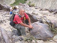
Christian Chabert delivers to us a passionnate story about his research
of pétropglyphes in Zanskar. Thank you Christian sharing to us
his passion for the petroglyphs of Northern Kashmir.
 Where
I found "animals and humans dancing on stones" is way up on
the map, stuck between Pakistan and Tibet, it's part of the huge Himalayan
mountain range that makes travellers dream and makes scholars and photographers
hallucinate - the Ladakh Zanskar. The country of "high passes"
is subject to a harsh climate. Its lowest valleys are above 2500m and
some summits are higher than 7000. A difficult region, protected from
the monsoon by a main range of high mountains and where life depends on
the water from the glaciers. The inhabitants manage untiringly, in tormented
massifs, in valleys difficult to reach that become totally inaccessible
during the winter that lasts six months. Where
I found "animals and humans dancing on stones" is way up on
the map, stuck between Pakistan and Tibet, it's part of the huge Himalayan
mountain range that makes travellers dream and makes scholars and photographers
hallucinate - the Ladakh Zanskar. The country of "high passes"
is subject to a harsh climate. Its lowest valleys are above 2500m and
some summits are higher than 7000. A difficult region, protected from
the monsoon by a main range of high mountains and where life depends on
the water from the glaciers. The inhabitants manage untiringly, in tormented
massifs, in valleys difficult to reach that become totally inaccessible
during the winter that lasts six months.
One of the contrasts of this region concerns isolation, a closed universe.
On the one hand, the inhabitants, either monks or civilians, love to travel
for their pleasure, a pilgrimage, a celebration or to exchange pashmina
wool, salt and yak butter. On the other hand, along the running water,
through the high passes of the Karakoram or the Himalayas, the men and
the caravans never stopped to transit, bringing with them new ideas and
products, to meet each other or exchange or sell. You should also be aware
of the fact that "recent history - very recent" also witnessed
the creation of new borders and their closing. (As in 1948 following the
invasion of lower Ladakh by Pakistan and in 1962 China who obtained vast
areas like Askat Chin).
|
A little bit of Geology
|
 Just
a little under 220 million of yrs, the "Indian Australian" sheet
loosened itself from the mega continent, the Gondwana. It started drifting
for approx. 90 million of yrs at an incredible speed of 20 cm per yr (the
drifts usually are 5 cm). The Australian sheet loosens itself. The Indian
sheet's now free and slides towards the north between two breaks. This
migration, will finally, 65 million yrs later, collide with a brutal shock
into the Eurasian sheet. The plates deform and organize themselves and
the Indian sheet slides as good as it can, under the Eurasian. To be more
precise, it fuses there, creating firstly an enormous mountain range :
the great Himalayas. Further on, other massifs like the sturdy Karakoram
which reaches 8000m or the Pamir complex. Other geological actions (sedimentary
deposits, volcanic, erosion, etc) will come to complete the relief Just
a little under 220 million of yrs, the "Indian Australian" sheet
loosened itself from the mega continent, the Gondwana. It started drifting
for approx. 90 million of yrs at an incredible speed of 20 cm per yr (the
drifts usually are 5 cm). The Australian sheet loosens itself. The Indian
sheet's now free and slides towards the north between two breaks. This
migration, will finally, 65 million yrs later, collide with a brutal shock
into the Eurasian sheet. The plates deform and organize themselves and
the Indian sheet slides as good as it can, under the Eurasian. To be more
precise, it fuses there, creating firstly an enormous mountain range :
the great Himalayas. Further on, other massifs like the sturdy Karakoram
which reaches 8000m or the Pamir complex. Other geological actions (sedimentary
deposits, volcanic, erosion, etc) will come to complete the relief
For more than 3000 Km, the results of this collision, "organized"
the mountains and depressions by aligning them "roughly", orienting
them from south-east towards north-west.
Himalaya, an impassable barrier ? One must always keep in mind the restraints
but also the facilities created by geology. After the obvious great obstacles,
one needs to look at its "weaknesses" regarding the passes or
large "passages" that follow the water currents. They use the
natural depressions, make use of "breaks" to go through the
massifs, creating 90° turns allowing them to join other rivers, for
eg. the Indus river and its nourishing basin that completes the Hunza.
|
Some rocks among others in Zanskar
|
|
|
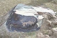
Pippula Altar (3800m) :
|
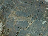
 After
crossing a stream, a small alluvial platform, on top of the Tsarap, we
can find various blocks of which about ten are engraved. One of them is
beautifully decorated and organized. Orientation east-west. The originality
of this rock is that it's the only one that I came across where I found
people in "orant" positions (both arms held up, one can imagine,
hands open and palms outstretched). On this rock, the subjects are not
only suggested but on the contrary, they seem to dance around the animals..
Seeing that there's no evident hunting scene, it immediately reminded
me of a praying altar. To the left, it could be a circling couple (or
maybe symbolically they affront each other ?). After
crossing a stream, a small alluvial platform, on top of the Tsarap, we
can find various blocks of which about ten are engraved. One of them is
beautifully decorated and organized. Orientation east-west. The originality
of this rock is that it's the only one that I came across where I found
people in "orant" positions (both arms held up, one can imagine,
hands open and palms outstretched). On this rock, the subjects are not
only suggested but on the contrary, they seem to dance around the animals..
Seeing that there's no evident hunting scene, it immediately reminded
me of a praying altar. To the left, it could be a circling couple (or
maybe symbolically they affront each other ?).
|
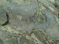
Char site (3850m)
|
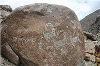
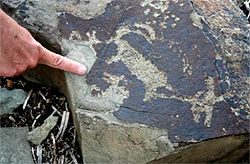 This
is one of the riches petroglyphic sites in Zanskar and which was one of
the first to be photographed, KLODZINSKI's studies. (1) To note,
it's situated approx 1 and a half Km before the junction with the Karigiak
Chu, on the left bank of the Tsarap Zamthong. It's crossed by the main
track of the valley. One can guess through the rocks polished by the glacier,
the remnants of a very old bridge going towards the agricultural terrace
of the chariot's homestead. On these stones, which could be like a "marvellous
valley", the other area, flat, surrounded by big old land slides,
we discover hunting scenes with either walking bow and arrow men or on
horses. A lot of animals are before our eyes, snow leopards, wolves or
dogs, old he-goats, bharals or urials, but also birds and yaks. One of
these big blocks has recently been engraved with Buddhist motifs (chortens).
Other sites (Hameling, Jal, Tangse) are before or follow the great passes
of this area. This
is one of the riches petroglyphic sites in Zanskar and which was one of
the first to be photographed, KLODZINSKI's studies. (1) To note,
it's situated approx 1 and a half Km before the junction with the Karigiak
Chu, on the left bank of the Tsarap Zamthong. It's crossed by the main
track of the valley. One can guess through the rocks polished by the glacier,
the remnants of a very old bridge going towards the agricultural terrace
of the chariot's homestead. On these stones, which could be like a "marvellous
valley", the other area, flat, surrounded by big old land slides,
we discover hunting scenes with either walking bow and arrow men or on
horses. A lot of animals are before our eyes, snow leopards, wolves or
dogs, old he-goats, bharals or urials, but also birds and yaks. One of
these big blocks has recently been engraved with Buddhist motifs (chortens).
Other sites (Hameling, Jal, Tangse) are before or follow the great passes
of this area.
|
Char : A fragile and unique patrimony
|
|
|
|
In 2006, Char become a stone quarry !
|
Close to the house, in the gardens, some beautiful blocks have already
been used as stone pits. Other engravings, along the path start to undergo
recent damage (tourists and/or local people). What's really worse is the
risk of unknowing destruction of a unique and exceptional space. The Char
inhabitants walk on the engravings because they represent short cuts and
then worse still, they break these rocks to use them. They don't recognize
their value, their classification and the need of protection of the whole
site. Flat, the closest prairie is well adapted for a natural camp for
trekkers. And the worse following indications - this place is unfortunately
retained for the future road that the Indian State wants to construct
(in 5 yrs - 10 yr ???)
|
The Indus Valley
|
 The
banks of the river have been very early used as a natural and principal
means of communication. It already went for more that 500 Km from its
spring in the east over the high "Great Tibet" plains, to finally
collapse in the west between the Zanskar and Ladakh massifs. The latter
is still more dry (90 mm of water per yr) and more mineral than the opposite.
The living areas were thus set up along the mountain streams coming from
crests and the vast dejecting cones of the rivers that flow into the Indus.
The inhabitable zones serve as in between the two gravel terraces, two
tight gorges, two practically deserted zones. The volume and violence
of the flowing water have re-enforced the importance of some key points
that allow a crossing. These areas had also to be without floods. The
capital of "Little Tibet" - Leh represents all these characteristics.
Ideally situated under the Kardung pass (5300m), its situation in all
four directions, has made of its " bazaar" the unavoidable junction
for caravans coming from Central Asia, China, India, Cachemir and Tibet. The
banks of the river have been very early used as a natural and principal
means of communication. It already went for more that 500 Km from its
spring in the east over the high "Great Tibet" plains, to finally
collapse in the west between the Zanskar and Ladakh massifs. The latter
is still more dry (90 mm of water per yr) and more mineral than the opposite.
The living areas were thus set up along the mountain streams coming from
crests and the vast dejecting cones of the rivers that flow into the Indus.
The inhabitable zones serve as in between the two gravel terraces, two
tight gorges, two practically deserted zones. The volume and violence
of the flowing water have re-enforced the importance of some key points
that allow a crossing. These areas had also to be without floods. The
capital of "Little Tibet" - Leh represents all these characteristics.
Ideally situated under the Kardung pass (5300m), its situation in all
four directions, has made of its " bazaar" the unavoidable junction
for caravans coming from Central Asia, China, India, Cachemir and Tibet.
The first petroglyphic studies in this part of the Himalaya were mainly
made by Hermann FRANCKE (2). To add also those of Karl JETTMAR
(3) of the rocks situated close to Pakistan. To note is that one of
the main affluent of the legendary river, flows in this area. In the north
south part of the Hunza river, the Karokoram Hwy was completed in 19/82.
Many trucks, beautifully decorated, now replace the caravans, as well
as the army, that ever since antiquity had no other choice but to use
this natural passage between Central Asia and the Indian continent or
go over the high passes of the Himalaya.
|
There's no shortage of engravings in Ladakh
|
 Alchi,
known for its monastery built in the 10th century, on the left bank of
the Indus. It's classified as on of the main world art works. Totally
ignored by many tourists and its inhabitants, a magnificent collection
can be found further down on the flat surface that dominates the river.
More than 10 rocks represent remarkable scenes. Hunts of the old he goats
by men with bows and arrows accompanied by dogs, felines with striped
bodies (tigers), squares, sun wheals, lightning signs or more animals.
On some of these we sometimes find chortens, these more recent Buddhist
engravings. There too, I was surprised to notice that the concentration
of petroglyphes seemed to be organized around ancient ways. This one goes
to the only passage where a bridge could have been built. Certainly a
very risky crossing when we see what's left of the ramps of the steep
river banks. Alchi,
known for its monastery built in the 10th century, on the left bank of
the Indus. It's classified as on of the main world art works. Totally
ignored by many tourists and its inhabitants, a magnificent collection
can be found further down on the flat surface that dominates the river.
More than 10 rocks represent remarkable scenes. Hunts of the old he goats
by men with bows and arrows accompanied by dogs, felines with striped
bodies (tigers), squares, sun wheals, lightning signs or more animals.
On some of these we sometimes find chortens, these more recent Buddhist
engravings. There too, I was surprised to notice that the concentration
of petroglyphes seemed to be organized around ancient ways. This one goes
to the only passage where a bridge could have been built. Certainly a
very risky crossing when we see what's left of the ramps of the steep
river banks.
Next to Leh, Phyang, Shey, Matho, Rumtek, Umla where the archaique petroglyphes
have already been well classified (4) and Taru (5) where,
for the last 3 yrs a "Rock Park" was established. I'd like to
mention "Raptsa". Between Indus and a high pass, a lost valley.
Between abrupt bare slopes, the stream flows through a pink granite canyon,
so characteristic of Ladakh. On the side of the mule track, small rounded
blocks are decorated. The sizes, the dimensions as well as the technique,
the drawings and patinas, resemble all those already mentioned. However,
overlooking the path, on the south face of a huge rock (3m - 3m) we can
find an exceptional hunting scene. Old he goats (?) striped, are followed
by walking hunters accompanied by dogs. The petroglyphes are of big dimensions,
especially three animals ( approx. 1m x 1m each). The work seems "fresh"
(?) but still much older than the neighbouring Buddhist signs.
The captivating moments of discovery in Sept. 2005 and then with Solonge
my wife in Sept. 2006, the desire to get to know more about the authors
and period of engraving, makes me decide to do some research. Apart one
photo in a tourist guide book (6), I can't practically find any
texts or images (7) concerning the petreglyphes of Ladakh Zanskar.
Finally I find the comparative study (8) of Henri Paul FRANCFORT
(9), Reserch Director of CNRS, a joint venture with Daniel KLODZINSKI
and Georges MASCLE (10). An exceptional opening regarding the engravers
of the Bronze and Iron Age in vast Asia.
|