|
|
CLIMBING
IN BIAFO AREA
- page 3/3 -
|
|
|
|
|
|
|
|
|
Here joints maps of the area :
|
|
|
|
|
|
|
|
|
|
|
|
|
Latok group -c6,456/c7,151m- :
|
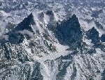 In
the upper Biafo area, the glance is attract by the Uzun Brakk valley
from where the imposing Ogre' group and the marvellous Gothic tower
of the Latoks group is rising up. Just as the Ogres, Latoks are difficult
and complex granite mountains, with the high towers and frozen barriers.
Moreover, Latok would like to say "difficult mountains" in
the language local Balti langage. The granite rock of the Latok-Baintha
Brakk group is as splendid as Trangos. The group includes 4 principal
summits which are Latok I, II, III and IV. These four summits were climbed
by their Southern slope starting from the Biafo glacier side. The first
climb was made by an Italians teams in 1977, the three others by Japanese,
two years later. In
the upper Biafo area, the glance is attract by the Uzun Brakk valley
from where the imposing Ogre' group and the marvellous Gothic tower
of the Latoks group is rising up. Just as the Ogres, Latoks are difficult
and complex granite mountains, with the high towers and frozen barriers.
Moreover, Latok would like to say "difficult mountains" in
the language local Balti langage. The granite rock of the Latok-Baintha
Brakk group is as splendid as Trangos. The group includes 4 principal
summits which are Latok I, II, III and IV. These four summits were climbed
by their Southern slope starting from the Biafo glacier side. The first
climb was made by an Italians teams in 1977, the three others by Japanese,
two years later.
|
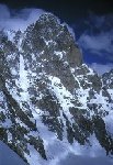
Latok I -c7,145m-, North face (Karakoram Walker)
:
|
 Brendan
Murphy and Dave Wills. Both had attempted the unclimbed 2,400m North
Ridge before and Wills was returning for his third attempt on this stupendous
line, often referred to as the Walker Spur of the Karakoram. After thorough
acclimatization, the two crossed the rimaye at c4,700m and climbed the
initial couloir to a tent site at 5,250m. In three days they climbed
1,500m of the ridge in the superb spell of weather that blessed the
Karakoram at the end of July. At the end of the third day they were
excavating a bivouac ledge on a sizable snow mushroom when the whole
thing collapsed. This resulted in Wills, unfortunately, joining the
elite ranks of a group of well-known climbers who have lost their rucksack
in a committing situation high on a big mountain. Included in the 'sack
were the tent, stove and his sleeping bag. Wills spent a thoroughly
miserable night and the pair made an 18 hour descent the following day
to their spare tent and a second stove left at 5,250m. Borrowing replacement
gear from the Ogre team, the pair made a second attempt in August but
only reached 5,880m before having to sit out three days of bad weather.
With the storm unabated they retreated once more. Brendan
Murphy and Dave Wills. Both had attempted the unclimbed 2,400m North
Ridge before and Wills was returning for his third attempt on this stupendous
line, often referred to as the Walker Spur of the Karakoram. After thorough
acclimatization, the two crossed the rimaye at c4,700m and climbed the
initial couloir to a tent site at 5,250m. In three days they climbed
1,500m of the ridge in the superb spell of weather that blessed the
Karakoram at the end of July. At the end of the third day they were
excavating a bivouac ledge on a sizable snow mushroom when the whole
thing collapsed. This resulted in Wills, unfortunately, joining the
elite ranks of a group of well-known climbers who have lost their rucksack
in a committing situation high on a big mountain. Included in the 'sack
were the tent, stove and his sleeping bag. Wills spent a thoroughly
miserable night and the pair made an 18 hour descent the following day
to their spare tent and a second stove left at 5,250m. Borrowing replacement
gear from the Ogre team, the pair made a second attempt in August but
only reached 5,880m before having to sit out three days of bad weather.
With the storm unabated they retreated once more.
In 1997, climbers from New England, John Bouchard and Mark Richey, joined
the growing ranks of climbers who have unsuccessfully attempted the
Walker Spur of the Karakoram the 2400m North Ridge of Latok I. This
pair made several lightweight and Alpine style forays on to the route,
reaching a high point of c6,000m before retreating due to the very dangerous
conditions brought on by the lengthy fine period of warm weather. Parties
who have climbed higher on the line know that above this point is a
very loose rock barrier which would undoubtedly be the source of considerable
objective danger in dry conditions. On their last attempt the two climbers
were joined by Tom Nonis and Barry Rugo, the other half of their expedition,
who had previously been attempting the Ogre.


|
Latok I -c7,145m-, North ridge :
|
 Tom
Nonis and Barry Rugo, the other half of their expedition, had previously
been attempting the Ogre. Bouchard and Richey already have the 7,145m
peak booked again for '98. On the neighbouring Latok I (7,145m) (see
Latok I) New Hampshire climbers, Tom Callaghan and Tom Nonis, abandoned
their attempt on the unclimbed North Ridge after Callaghan injured a
knee early in the expedition. Before the incident the pair had made
several trips up to 5,500m over a 19-day period of consistently poor
weather. Tom
Nonis and Barry Rugo, the other half of their expedition, had previously
been attempting the Ogre. Bouchard and Richey already have the 7,145m
peak booked again for '98. On the neighbouring Latok I (7,145m) (see
Latok I) New Hampshire climbers, Tom Callaghan and Tom Nonis, abandoned
their attempt on the unclimbed North Ridge after Callaghan injured a
knee early in the expedition. Before the incident the pair had made
several trips up to 5,500m over a 19-day period of consistently poor
weather.
|
Latok II -c7,151m- :
|
 First
climb by italians team (leader Bergamaschi in 1977), second by japanese
in 1979. The west ridge has severals attempts, high point ever climbed
was c,6,850m by this route. In 1995, A german attempt lead by the famous
climber Alexander Huber) by a new route on the impressive Southwest
face (800m high) in 1994. First
climb by italians team (leader Bergamaschi in 1977), second by japanese
in 1979. The west ridge has severals attempts, high point ever climbed
was c,6,850m by this route. In 1995, A german attempt lead by the famous
climber Alexander Huber) by a new route on the impressive Southwest
face (800m high) in 1994.
|
Latok II -c7,108m-, North West ridge :
|
Latok II and especially the North West Ridge has a long history, primarily
involving British expeditions. It was first attempted from the col below
Ogre II by a Japanese team in 1975 but they abandoned their project
due to rockfall and serious avalanche danger. In 1977 and '78 two British
parties made further progress and reached c6,600m, although both attempts
were marred by the death of climbers; Don Morrison on the first due
to a crevasse fall and Pat Fearneough in '78, hit by stonefall in the
dangerous Braldu Gorge. In 1987 Joe Brown and Dee de Mengel from a strong
eight-man team retreated from above 6,800m in a serious storm. What
now remains is an integral ascent of the entire ridge above the col.
|
Latok II -c7,108m-, South ridge :
|
 The
mountain itself has been climbed only twice, first in 1977 by Arturo
Bergamaschi's Italian expedition, succeeded in forcing a route up mixed
ground on the tapering South Ridge, with Alimonta, Mase and Valentini
reaching the top well into the night after a long push from their top
camp (Camp 5) in bad weather. Above Camp 4 the route was over rock and
mixed ground (pitches of IV) to a lower South Summit, in turn connected
to the highest point by a narrow snow arête which took three hours
to cross. Some days later four more Italians were able to reach the
South Summit but turned back from this point. The route does not appear
to have been attempted since. The
mountain itself has been climbed only twice, first in 1977 by Arturo
Bergamaschi's Italian expedition, succeeded in forcing a route up mixed
ground on the tapering South Ridge, with Alimonta, Mase and Valentini
reaching the top well into the night after a long push from their top
camp (Camp 5) in bad weather. Above Camp 4 the route was over rock and
mixed ground (pitches of IV) to a lower South Summit, in turn connected
to the highest point by a narrow snow arête which took three hours
to cross. Some days later four more Italians were able to reach the
South Summit but turned back from this point. The route does not appear
to have been attempted since.
|
Latok II -c7,108m-, "Tsering Mosong"
line :
|
 One
of the most outstanding achievements of the season 97 was the first
ascent of the Southwest Face of Latok II by the well-known German brothers
Alexander and Thomas Huber, plus the equally well-known American, Conrad
Anker and a fourth German climber, Toni Gutsch. These four reached the
7,108m summit on the 19th July after having climbed a hard big wall
route up the 1,000m+ sheer face above the huge central couloir. One
of the most outstanding achievements of the season 97 was the first
ascent of the Southwest Face of Latok II by the well-known German brothers
Alexander and Thomas Huber, plus the equally well-known American, Conrad
Anker and a fourth German climber, Toni Gutsch. These four reached the
7,108m summit on the 19th July after having climbed a hard big wall
route up the 1,000m+ sheer face above the huge central couloir.
In August 1995 Alexander Huber, on a seven member German team led by
Jan Mersch, had hoped to attempt the face, which rises a total of 2,300m,
but unstable weather and very poor conditions in the couloir had proved
too dangerous and instead the team attempted the North West Ridge from
the col below Ogre II, reaching a height of c6,600m.
In 1997, hoping to find the couloir in a safer and more snowy condition
by arriving earlier in the year, the team assembled at a Base Camp (4,400m)
close to the Uzum Brakk Glacier on the 14th June with around 2,000m
of rope and the obligatory film crew from Mountain Air Productions.
The climbers then sited a camp in the lower part of the 50 couloir at
c5,600m and around the 24th June began fixing rope up the snow and ice
above. Unfortunately, rockfall was every bit as bad as on their previous
attempt and although the team only climbed this section during the night,
the ground was still considered extremely hazardous. A second camp was
established at 6,000m tucked in below the upper rock wall. From there
the four slanted up the left branch of the couloir for 100m before taking
off up the wall and fixing eight pitches to a portaledge bivouac on
the prominent break at about one third height. The first pitch proved
to be the hardest free climbing attempted (VII or 5.10c), while the
fourth gave some taxing aid on loose terrain at hard A3. The rack consisted
of 50 karabiners, 20 Friends, 30 nuts, 15-20 pegs and five Birdbeaks,
six assorted skyhooks and some 6mm rivets. From the portaledge bivouac
ropes were then pushed out to around 6,900m, at which point the climbers
were able to see monsoon clouds building to the west. Fortunately, they
were able to climb the last section to reach the final snowy ridge and
the highest point (via a pitch of V) on the 19th July. Eleven climbing
days were required to complete the wall, the Huber brothers spending
six nights at the portaledge bivouac and Anker and Gutsch seven. The
descent was reported to be decidedly dangerous due to worsening conditions
and at one point the 5,600m camp was hit by rockfall, resulting in the
loss of two sacks of gear.
The 25-pitch route (seven of which were A3) was given an overall American
grading of VII and christened Tsering Mosong, the Balti expression for
Long Life. Twenty of these pitches were either vertical or overhanging,
making the line relatively sheltered from any debris falling from above.
However, the hard aid pitches were generally loose and the leader was
often looking at a huge fall should things go wrong. In terms of altitude
the four climbers had completed probably the highest big wall climb
in the world; up a face as huge and as steep as Yosemite's El Capitan
but situated at an altitude almost 5,000m higher.
|
Latok II -c7,108m-, "Nomadu" line :
|
 Franz
Fendt and Christian Schlesener, reached the Latok II summit via the
North West Ridge to make the third overall ascent of the mountain. On
their second attempt this pair left the camp below the headwall at 6,000m
and climbed up the left branch of the couloir to reach the crest of
the ridge at c6,600m. The eight pitches of this section gave difficult
technical climbing with two hard cruxes and the ridge above provided
more technical ground with short, hard rock steps. The pair reached
the summit after 36 hours of continuous climbing with difficulties up
to VI+ and A2 plus 80-90 ice. They then spent 14 hours rappelling the
route to their 6,000m camp and a well-earned sleep before continuing
down the stoneswept couloir to Base Camp. The new 1,100m line above
the last camp in the couloir was named Nomadu. Franz
Fendt and Christian Schlesener, reached the Latok II summit via the
North West Ridge to make the third overall ascent of the mountain. On
their second attempt this pair left the camp below the headwall at 6,000m
and climbed up the left branch of the couloir to reach the crest of
the ridge at c6,600m. The eight pitches of this section gave difficult
technical climbing with two hard cruxes and the ridge above provided
more technical ground with short, hard rock steps. The pair reached
the summit after 36 hours of continuous climbing with difficulties up
to VI+ and A2 plus 80-90 ice. They then spent 14 hours rappelling the
route to their 6,000m camp and a well-earned sleep before continuing
down the stoneswept couloir to Base Camp. The new 1,100m line above
the last camp in the couloir was named Nomadu.
|
Latok III -c6,949m- :
|
 The
impressive rock pyramid of Latok III was first climbed in July 1979
by Sakae Mori, Kazushige Takami and Yoji Teranishi, members of a Japanese
team that fixed 1,600m of rope on the difficult Southwest Ridge (VI+
and A2). The
impressive rock pyramid of Latok III was first climbed in July 1979
by Sakae Mori, Kazushige Takami and Yoji Teranishi, members of a Japanese
team that fixed 1,600m of rope on the difficult Southwest Ridge (VI+
and A2).
In largely stable weather Alex Franklin, Will Garrett, Fiona Hatchell,
Colin Spark and Guy Willett, all from the UK, attempted several peaks
from the Choktoi Glacier during the latter part of June plus July 1997,
without succes. The group report much abandoned rubbish at some old
Base Camps of German origin. They were able to porter out c25kg of trash
from one of these camps which is now all but clear, leaving just one
or two other sites, which it is hoped might be tackled by future parties
visiting this relatively accessible area.
|
Latok III, borrow summit (Indian Face Spur) -c5,200m-:
|
 In
1990, the Indian Face Spur, the fine granite pillar was climb by Sandy
Allan and Doug Scott in 1990. The UK group climbed approximately one
third of the way up the pillar at British HVS and A1/A2 but retreated
with the realization that the route was far longer than it looked. However,
they were able to reach the summit of Pt 5,400m via a loose ridge at
AD standard. The group report much abandoned rubbish at some old Base
Camps of German origin. They were able to porter out c25kg of trash
from one of these camps which is now all but clear, leaving just one
or two other sites, which it is hoped might be tackled by future parties
visiting this relatively accessible area. In
1990, the Indian Face Spur, the fine granite pillar was climb by Sandy
Allan and Doug Scott in 1990. The UK group climbed approximately one
third of the way up the pillar at British HVS and A1/A2 but retreated
with the realization that the route was far longer than it looked. However,
they were able to reach the summit of Pt 5,400m via a loose ridge at
AD standard. The group report much abandoned rubbish at some old Base
Camps of German origin. They were able to porter out c25kg of trash
from one of these camps which is now all but clear, leaving just one
or two other sites, which it is hoped might be tackled by future parties
visiting this relatively accessible area.
In 1999, Chinnery, Coull and Morton were making their final push on
the West Face of Indian Face Spur. The crest of this prominent rock
spur below a subsidiary summit of Latok III was first climbed in 1990
by Sandy Allan and Doug Scott at British 5c and A2. However, this pair
stopped at a pinnacle some distance below the actual summit and made
a rappel descent of the steep North Face to the left. The new Scottish
line climbs the obvious groove that runs up the vertical West Face of
the Arete, starting 80m up the central snow couloir. This gave continuous
aid climbing for 400m with difficulties up to A3 before joining the
crest of the arete at around half-height. The climbers spent five days
fixing rope on the groove, returning to Base Camp each night. On the
27th they jumared the ropes to the crest, removing all the fixed gear
as they went, then continued up the original route for a further 400m
(passing in situ gear from the Italian attempt: see below) to reach
the summit - the highest point on the crest of the ridge - on the 28th.
The second half of the climb gave British VS climbing with one pitch
of A2. This was the first route to reach the summit of the 'Indian Face',
allowing a more straightforward descent to be made by rappelling the
South East Flank.
Prior to these ascents the area had already been visited in June by
the Italian team of Luca Maspes, Emanuele Pellizzari Massimo Sala and
Gianni Zappa. These four remained for 18 days at or above their Base
Camp close to the start of the glacier. Twelve of these days were considered
unsuitable for climbing, having very poor weather or snowfall. Sala
and Zappa climbed a 700m high pillar on a small unnamed rocky summit
of 4,750m, situated on the south side of the glacier about one hour
above Base Camp. Traditional protection was used throughout and difficulties
up to F6a+ and A1 were experienced. The route was completed in a long
day from Base Camp, the trio descending from the summit via three rappels
in a couloir to the east and returning the same day.
Maspes, Pellizzari and Zappa then repeated the Indian Face Spur, thinking
they were on new ground. They climbed the first three pitches one afternoon
and fixed ropes. It then snowed for three days after which they began
again, adding eight more pitches and passing a jammed Friend left by
Allan in 1990. The following day they climbed another six pitches and
on the final day one more pitch to the pinnacle, which marks more or
less the same high point as Allan and Scott in 1990 (which they estimate
to be roughly five pitches of easier ground from the c5,200m summit).
Making one rappel from their high point, the Italians found traces of
the top bivouac (including a rappel sling) used by the British pair
in 1990. They too bivouacked at much the same spot. Whether they followed
the same line as that taken by Allan and Scott is unclear but apart
from the first 70m and two pitches in the middle of the route, each
rope length had a minimum grade of VI and A1, with the fifth pitch the
crux (VIII- and A1). The three Italians placed four bolts: two on belays,
one for protection on a pitch of very rotten rock (graded A2+ and VI)
and a fourth (subsequently removed) when the leader was caught out by
nightfall. They rappelled the line (setting up either two-peg or one-bolt
anchors), all very impressed with the level of difficulty and commitment.
Shortly after, Maspes made a solo ascent of a small rocky summit of
4,650m, which he christened Simo Peak, close to Base Camp. He climbed
the South East Face, which gave 400m of climbing up to V, then descended
via an easy rock gully. The team were disappointed with the amount of
rubbish they discovered (and subsequently partially brought back) at
the Base Camp sites below the Latok Group, particularly abandoned tents,
batteries etc, which appeared to be of French origin.
|
Latok III -c6,949m-, West face :
|
 The
West Face of Latok III is c2,000m high with the first section a snow/ice
slope followed by an impressively steep rock wall, well-seen in the
book Himalayan Alpine-Style. The
West Face of Latok III is c2,000m high with the first section a snow/ice
slope followed by an impressively steep rock wall, well-seen in the
book Himalayan Alpine-Style.
The West Face was the target of Enrico Rosso and two Italian companions
in 1988. However, on finding the face too plastered with snow, they
decided to repeat the safer Japanese Route and in demanding conditions
completed the climb in a eight-day, Alpine style push. The West Face
was thought to have been attempted in the '90s by an American team that
included Phil Powers from the National Outdoor Leadership School. Until
last summer Latok III does not appear to have been attempted since.
The face is 2,000m high with the first section a snow/ice slope and
the upper 1,300m an impressively steep rock wall at relatively high
altitude. This face was the target of Enrico Rosso's team in 1988 but
finding it too plastered, the Italians turned to the original Japanese
Route on the Southwest Ridge and completed it Alpine style in eight
days (VI+ and A2). The next and what appears to be the best attempt
to date came in 1992 when Americans, Greg Collum and Phil Powers, reached
a point three pitches above a snow-covered spur in the centre of the
face at an altitude of approximately 6,350m. Latterly, in July 1998,
a high point of around 6,050m was reached by another strong American
team comprising Kitty Calhoun, Steve Quinlan, Ken Sauls and Jay Smith,
who report overcoming difficulties of 5.10a and A2 on less than perfect
rock.
Latok III was to be the fourth summit of the on-going project entitled
'Russian Way - Big Walls of the World'. Base Camp was established on
the moraine two hours from the base of the wall and after an acclimatization
climb an advanced camp was set up closer still to the wall. Koshelenko
had hoped the team would attempt the face in Alpine style but he was
out-voted on his choice of line and the four went for a directissima
towards the left side of the face that would require a capsule style
approach and much aid. They started their ascent on the 19th July. hauling
an initial load of 100kg up the broad couloir on the left side of the
face. The four took two days and climbed around 25 pitches to get established
at the start of the rock wall (5700m). A heavy snow covering on the
45-60° ice slope had made the ascent to this point hard work. Above,
the team progressed slowly, climbing only two-and-a-half pitches over
the next two days (6 and A3+) to reach an altitude of c5,835m. The corner
they were trying to ascend was composed of poor rock and Koshelenko's
suggestion to descend and outflank the obstacle by climbing the buttress
on the left appears to have been ignored. If further proof were needed,
while lying on their portaledge at the end of a day in which Koshelenko
had already received a cut to the head from a falling stone, a large
rock burst through the tent fly and completely shattered Koshelenko's
helmet.
It snowed heavily for two days, confining the Russians to their ledge.
However, on the 25th the weather seemed to be on the mend and the team
set off up the wall, only to get caught in more stonefall. This time
Koshelenko, who was jumaring back up the fixed ropes, was hit on the
hands. The result was two broken thumbs and a decision to retreat.
On the 26th they started down. The sky was cloudless and the ice slopes
now heavily laden with snow. Koshelenko was lowered, Ruchkin came next
setting up the rappel anchors, then Efimov and finally Odintsov. At
around 3.30pm the team were on the lower section of the face and only
five rope lengths above the glacier, when they were pummelled by an
avalanche that left a two-metre groove in the slope above. At that point
Efimov and Ruchkin were together. They set up a belay on ice screws
out of the fall line, then proceeded to lower Koshelenko while Odintsov
waited one pitch above. Suddenly, another big avalanche hit. When Ruchkin
finally emerged from the debris, badly battered with three broken ribs
and a damaged neck, he found himself alone apart from two ice-axes.
Efimov, the rucksacks and remaining ice tools and been swept away.
Odintsov came down and the three descended painfully to the foot of
the face, where to their surprise they found Efimov sitting to one side
of the base of the avalanche cone and all their equipment scattered
close by. While his companions thought he had been killed in the avalanche,
Efimov was convinced he was the only survivor after his 350m fall and
at around 4pm had radioed Michail Bakin, a Russian doctor in Base Camp,
to that effect.
Bakin, Odintsov, plus the injured Klenov and Koshelenko managed to transport
Efimov, who had broken a leg and ribs, down to a safe point on the glacier
but not before they had another lucky escape when a huge rockfall from
the face above stopped in the avalanche cone just 20m away. The path
out from Base Camp was too narrow and precariously positioned to carry
an invalid, so the Russian's Liaison Officer made a rapid descent to
Skardu to order a helicopter. There appears to have been a lengthy administrative
delay before one could be released but on the 30th July and after the
intervention of the Russian Embassy, Bakin and Efimov were successfully
flown to Skardu hospital and the rest were able to walk out, arriving
on the 3rd August.
In 2001, Odintsov organized a second team for a return match. Out of
the original party it seems that only Ruchkin was interested but the
pair enlisted Igor Barikhin, Mikhail Davy, Sergey Khadzhinov and Alexander
Klenov. Base Camp was established at the former site late on the 22nd
June and subsequently, while waiting for some delayed baggage, all members
made an acclimatization ascent of a small subsidiary summit of the Latok
group, which they refer to as Latok VI. The party slept the night on
the top. The capsule attempt on Latok III began on the 7th July, the
team spending two days climbing and hauling equipment to the top of
the ice slope below the start of the big corner system. Realizing, even
from far away, that stonefall in the corner was no less dangerous than
the previous year, the team decided to pursue a more sheltered line
up the flank of the pillar to the left. By the night of the 10th they
had established a portaledge camp halfway up this wall. Unfortunately,
the rock was far from good, making solid protection difficult to arrange
and there was still a problem from stonefall. On the 10th, Odintsov
was hit hard in the back by a rock and although there were no breaks,
he was badly bruised, making further climbing difficult. On the 15th,
now some distance above their 2000 high point, the weather deteriorated
and at the end of the day an exhausted Khadzhinov and Ruchkin fell asleep
in their sealed portaledge while making tea and ended up with bad carbon
monoxide poisoning. It snowed for the next one and a half days but in
the evening of the 18th the Russians had reached the prominent elongated
snow patch, christened The Tomahawk and situated below the upper pillar.
According to Odintsov, the climbing to this point had not been excessively
difficult but almost constantly dangerous due to poor rock and stonefall.
The following day they moved up to c6,200m, a point estimated to be
two days' climbing from the summit. Barikhin was last man, jumaring
the ropes and removing protection and belay anchors. The weather was
nice and sunny during the evening and as Barikhin ascended the last
rope and the rest of the team were preparing a site for the night, a
large rockfall Suddenly cut loose from the summit ridge. Blocks flew
past in all directions but cowering close to the rock the five climbers
at the proposed camp site avoided being hit. However, when calm returned,
they realized the rope below had been cut and Barikhin had disappeared.
Odintsov rappelled for 50m but could see no sign of him. The following
morning the team abandoned the climb and descended, finding Barikhin's
body just 20m above the rimaye at the bottom of the face.
|
Latok IV -c6,456m- :
|
Ohmiya is no newcomer to this region. In 1980 he made the first and,
until last summer, only ascent of Latok IV (6,456m) via the Southwest
Face, just to the right of Latok V. While excavating a snow cave on
the descent both Ohmiya and his partner, Koji Okano, fell 50m into a
crevasse, breaking a number of bones. They waited for four days but
when no help came Ohmiya managed to tunnel through the outside wall
of the crevasse and crawl down the glacier with a broken leg. In close
proximity at the time were Victor Saunders and Will Tapsfield, who had
been attempting nearby Uzun Brakk. This pair were informed of the accident
and subsequently climbed up to the crevasse on Latok IV, where Okano,
who had been stranded down the hole for eight days, was successfully
pulled to safety.
In 2001, a very strong German team comprising Toni Gutsch, Alex and
Thomas Huber, and Jan Mersch attempted the South Pillar of the Ogre,
one of the Karakoram's most famous mountains and despite more than 15
attempts still unclimbed since its legendary first ascent in 1977 by
Chris Bonington and Doug Scott (see Ogre, South face).
When Gutsch and Mersch went home, the Huber brothers were left with
five days before porters arrived to evacuate Base Camp. They decided
to attempt a very lightweight dash up the Southwest Face of Latok IV
(6,456m), climbed only once before by the Japanese, Ohmiya and Okano
(see above). The two brothers made the 12kms approach from Base Camp
during the night, then climbed mostly unroped up the steep snow and
ice slopes of the face and into the final couloir leading to the gap
between the twin summits. They opted for the closer and slightly lower
South Summit, reached it a little after midday and returned to Base
Camp in a 22 hours round trip.
|
Latok V -c6,190m-:
|
Latok V is the name ascribed to the small 6,190m pyramid that stands
at the end of the South East Ridge of Latok III (6,949m) on the watershed
running between Latok III and IV. It is probably, though by no means
certainly, unclimbed and was attempted last summer by Motomo Ohmiya
and partner.
In 1999, the Japanese climber Moromu Omiya returned for his third attempt
on the unclimbed 6,190m summit of Latok V. Omiya, who made the first
ascent of Latok IV in 1980, attempted this small peak in both 1999 and
2000 via the South Face. Last summer with two other companions he again
tried the mountain but on the summit day was forced to give up just
70m below the top when it simply became too late to continue safely.
The peak lies at the end of the South East Ridge of Latok III.
|
Latok VI :
|
In 2001, Odintsov organized a second team for a return match. Out
of the original party it seems that only Ruchkin was interested but
the pair enlisted Igor Barikhin, Mikhail Davy, Sergey Khadzhinov and
Alexander Klenov. Base Camp was established at the former site late
on the 22nd June and subsequently, while waiting for some delayed baggage,
all members made an acclimatization ascent of a small subsidiary summit
of the Latok group, which they refer to as Latok VI.
|
Redakh Brakk -c6,000m- :
|
In a good example of exploratory mountaineering during July/August
the experienced four man British team of Bill Church, Tony Park, Colin
Wells and Dave Wilkinson climbed three previously virgin peaks from
a Base Camp off the Kero Lungma Glacier (immediately south of the Hispar
and approached from Skardu via Arandu). The team's original intention
had been to attempt a c6,000m peak seen the previous year and dubbed
Mystery Mountain. They were able to locate its position on existing
maps but once in the field found that an intervening glacier basin,
not marked on any maps, meant that the peak was unreachable from the
Kero Lungma. In changeable weather and with masses of old spring snow
(but little problem with fresh snow) they turned their attentions to
a 5,000m peak on the south side of the glacier, later christened Tsuntse
Brakk, which gave 1,000m of PD climbing with a pitch of Scottish 3.
After this they tackled a 5,200m peak (Goma Brakk) directly opposite
on the north side of the glacier (1,000m: F) and finally, on the 13th
August, made the first ascent of Redakh Brakk (c6,000m), which lies
on the watershed with the Hispar Glacier. The route from the south was
via a complex but easy glacier to a col on the main divide and AD+ snow
and ice up the West Ridge to finish. Errors on existing maps were corrected
in a fine piece of traditional exploration and Wilkinson plans to return
this year for a crack at Mystery Mountain.
|
Spaldang Peak -c5,550m- :
|
Preparing the Biantha Brakk expedition, Huber then teamed up with
Volker Benz and Karl Spitzhof to make the first ascent of a nearby 5,550m
tower which they christened Spaldang. The 900m high route on the East
Pillar (1,400m of climbing) was partially sieged. The lower section,
which was not so steep, gave fairly reasonable climbing (IV to VI) to
a shoulder below the steep upper pillar. The upper section proved to
be generally V and VI, except for the 120m headwall which was split
by a perfect hand jam crack and fell to Huber at IX- (around F7b/7b+).
This was a very impressive performance at the altitude, although by
this stage in the expedition Huber was well-acclimatized and presumably
still retained some of the old magic that allowed him to free climb
the Salathé earlier in the year.
|
Shel Chakpa -c5,800m- :
|
 Dave
Wilkinson returned to old haunts in 1999 with a visit to the Arandu
(Basha River) Valley in the company of fellow British mountaineers,
Bill Church, Gus Morton and Stewart Muir. The objective this time was
a fine, pointed snow peak of c5,800m towards the head of the valley
that rises east from the village of Zil towards the flanks of the Ganchen
Massif. Dave
Wilkinson returned to old haunts in 1999 with a visit to the Arandu
(Basha River) Valley in the company of fellow British mountaineers,
Bill Church, Gus Morton and Stewart Muir. The objective this time was
a fine, pointed snow peak of c5,800m towards the head of the valley
that rises east from the village of Zil towards the flanks of the Ganchen
Massif.
After an initial reconnaissance to confirm the existence of a feasible
ascent line, the four established Base Camp on the 18th July at c4,050m.
According to the local population the British climbers were the first
foreign party to visit this valley and their proposed summit already
had the name Shel Chakpa. This Balti name means 'white broken peak',
quite appropriate for a mountain with such considerable serac structure
on its flanks. From Base Camp the West North West Ridge appeared to
offer the safest and most feasible line of ascent. However, two weeks
of warm and unsettled weather prevented a serious attempt until the
5th August, after which the team made a successful ascent and descent
of the mountain over the next five days. The climbing on the first day
proved straightforward but the second involved TD ice/mixed terrain
to by-pass a set of shattered rocky towers on the lower part of the
ridge. From Camp 2 at 5,000m the four continued up the ill-defined ridge,
almost immediately finding a well-built cairn, which they surmise had
probably been constructed by an enterprising ibex hunter coming up broken
rocky ground to the south. Above, the difficulties increased and a meandering
line up icy ramps and gullies at TD standard led to the summit. Descent
was made largely by rappel, and in dry conditions, caused by the high
temperatures at these modest altitudes during the Karakoram summer,
stonefall lent an urgency to the situation. A rest day at Camp 2 was
taken on the 9th and all four descended safely to Base Camp on the following
day.
|
Sokha Brakk -c5,956m-:
|
Two British climbers, Ian Arnold and Dave Millman, were visiting the
adjacent Sokha Glacier to the south, where they managed to climb one
small peak. Arnold had visited the glacier twice before and, in 1992,
climbed the South Face of Pt 5,495m (IV+) and made a spirited attempt
on the difficult and serious North Face of Pt 5,956m, an unclimbed peak
on the main ridge southwest of Sosbun Brakk, subsequently christened
Sokha Brakk. Little climbing has ever been attempted on the Sokha's
dramatic peaks, though the glacier was visited as early as the first
part of last century by the indefatigable Bullock-Workmans and then
again in the late '30s by first Tilman then Scott Russell.
Attempts on other peaks in the region were thwarted by bad weather and
although the team note considerable potential for future parties, there
is little that would give easy climbing and approaches would be far
from straightforward.
(See the common topics for more informations for the area : Redakh Brakk,
Hispar& Sokha pass, Solu & Sokha glaciers).
|
Sokha Brakk (Sekha Brakk/Dragonfly Crest), -c5,450m-
:
|
Dave Wilkinson returned to old haunts in 1999 with a visit to the
Arandu (Basha River) Valley in the company of fellow British mountaineers,
Bill Church, Gus Morton and Stewart Muir. The objective this time was
a fine, pointed snow peak of c5,800m towards the head of the valley
that rises east from the village of Zil towards the flanks of the Ganchen
Massif.
The British team chose to reconnoitre the unnamed side glacier rising
north from their Base Camp but found the abnormally dry winter and spring
had made approaches to many of the peaks both difficult and dangerous.
The team was also bugged by the generally very unsettled weather but
managed to climb one c5,450m peak on the Hispar watershed ridge. They
named this Sekha Brakk (Dragonfly Peak).
|
Sosbun Brakk -c6,413m- :
|
 H.W.Tilman,
before the war, had drawn attention to the slim tops of the valley of
Hoh Lungma. It described it, in " Blank one the map " (E.Shipton)
as "an uncompromising rock wall crowned with jagged towers".
But the beauty of these peaks is misleading: the rock is dangerous with
enormous rotted scales and cracks with sandy edges : Sosbun mean "
heap's stone " in baltis and is well named. The climbing is very
hard, as on the very beautiful face, 1100m high, vertical and often
overhanging. H.W.Tilman,
before the war, had drawn attention to the slim tops of the valley of
Hoh Lungma. It described it, in " Blank one the map " (E.Shipton)
as "an uncompromising rock wall crowned with jagged towers".
But the beauty of these peaks is misleading: the rock is dangerous with
enormous rotted scales and cracks with sandy edges : Sosbun mean "
heap's stone " in baltis and is well named. The climbing is very
hard, as on the very beautiful face, 1100m high, vertical and often
overhanging.
First and unique climb of the Sosbun summit in 1981 by the Japaneses
H.Hashimoto and N.Matsumoto: they followed the difficult, elegant and
very pure Southwestern edge (5 camps, a bivouac). Frenchies B. Domenech,
Y.Duverney and J.P. Monet approached it in 1989; they stopped in a storm,
under the slopes of the top which is the end of the difficult section
(700m, 6b/A4). Undoubtedly disappointed, but adventure is always worth
on this splendid mountain.
|
Tsuntse Brakk-:
|
In a good example of exploratory mountaineering during July/August
the experienced four man British team of Bill Church, Tony Park, Colin
Wells and Dave Wilkinson climbed three previously virgin peaks from
a Base Camp off the Kero Lungma Glacier (immediately south of the Hispar
and approached from Skardu via Arandu). The team's original intention
had been to attempt a c6,000m peak seen the previous year and dubbed
Mystery Mountain. They were able to locate its position on existing
maps but once in the field found that an intervening glacier basin,
not marked on any maps, meant that the peak was unreachable from the
Kero Lungma. In changeable weather and with masses of old spring snow
(but little problem with fresh snow) they turned their attentions to
a 5,000m peak on the south side of the glacier, later christened Tsuntse
Brakk.
|
Uzum Brakk -~6500m- :
|
After their failure on Latok II, in 1994, Alexander Huber accompanied
by seven German tried the Southern face while passing by the higher
Uzum Brakk glacier in 1995. The route borrows the fine Southern ridge
with obvious technical problems in the higher section (first time tried
by a Japanese group in 1975 and later by a certain number of British
forwardings but remains always virgin). Some members of the team arrived
above 6500m.
|
Workman peak -c5,882m- :
|
The five-member italians team was on the Biafo Glacier in 1999 for
almost a month from mid-July to mid-August but poor weather prevented
them from achieving more than two ascents. On the 23rd July 1999, Giangi
Angeloni, Angelo Carminati, Giorgio Carran, Gigi Rota and Ennio Spiranelli
climbed the Central Spur on the West Face of Workman Peak (5,882m),
finding snow and mixed terrain up to 60°. On the 28th, Angeloni,
Rota and Spiranelli climbed a nearby c5,800m summit, for which they
propose the name Tarci Peak after the great Bregaglia/Masino activist,
Tarcisio Fazzini, killed during the winter of 1990 in an avalanche.
The three Italians climbed the 600m South Ridge and West Face, which
gave 12 rock pitches up to VI.
|
Sources :
All informations mainly coming from,
Ø The American Alpine Journal, 1996 to 2004 editions
Ø Himalaya in Alpin Style by Andy Fanshawe & Stephen
Venables, (Arthaud - France), 192 pages, 1996 edition
Ø The Karakorum, Mountains of Pakistan de Shiro Shirahata
édition Ferezsons (pvt.) ltd
Ø Les plus belles montagnes du monde (Glénat -
Grenoble-France), 296 pages, 1993 edition
Ø Himalaya-Karakoram, Mountains of Pakistan by Shiro
Shirahata, (Denoël - France), edition 1990
Ø Ils ont conquis l'Himalaya by Bernard Pierre (Plon -
France), 1979 edition
Ø Deux siècles d'alpinisme by Chris Bonnington
(Delachaux & Niestlé), 1992 edition
... and some others. All informations compiled by Blankonthemap.
|
To the same topics:
|
|
Révision A - 23/12/06 (http://blankonthemap.free.fr)

|

