|

|
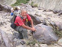
Christian Chabert delivers to us a passionnate story about his research
of pétropglyphes in Zanskar. Thank you Christian sharing to us
his passion for the petroglyphs of Northern Kashmir.
 Where
I found "animals and humans dancing on stones" is way up on
the map, stuck between Pakistan and Tibet, it's part of the huge Himalayan
mountain range that makes travellers dream and makes scholars and photographers
hallucinate - the Ladakh Zanskar. The country of "high passes"
is subject to a harsh climate. Its lowest valleys are above 2500m and
some summits are higher than 7000. A difficult region, protected from
the monsoon by a main range of high mountains and where life depends on
the water from the glaciers. The inhabitants manage untiringly, in tormented
massifs, in valleys difficult to reach that become totally inaccessible
during the winter that lasts six months. Where
I found "animals and humans dancing on stones" is way up on
the map, stuck between Pakistan and Tibet, it's part of the huge Himalayan
mountain range that makes travellers dream and makes scholars and photographers
hallucinate - the Ladakh Zanskar. The country of "high passes"
is subject to a harsh climate. Its lowest valleys are above 2500m and
some summits are higher than 7000. A difficult region, protected from
the monsoon by a main range of high mountains and where life depends on
the water from the glaciers. The inhabitants manage untiringly, in tormented
massifs, in valleys difficult to reach that become totally inaccessible
during the winter that lasts six months.
One of the contrasts of this region concerns isolation, a closed universe.
On the one hand, the inhabitants, either monks or civilians, love to travel
for their pleasure, a pilgrimage, a celebration or to exchange pashmina
wool, salt and yak butter. On the other hand, along the running water,
through the high passes of the Karakoram or the Himalayas, the men and
the caravans never stopped to transit, bringing with them new ideas and
products, to meet each other or exchange or sell. You should also be aware
of the fact that "recent history - very recent" also witnessed
the creation of new borders and their closing. (As in 1948 following the
invasion of lower Ladakh by Pakistan and in 1962 China who obtained vast
areas like Askat Chin).
|
A little bit of Geology
|
 Just
a little under 220 million of yrs, the "Indian Australian" sheet
loosened itself from the mega continent, the Gondwana. It started drifting
for approx. 90 million of yrs at an incredible speed of 20 cm per yr (the
drifts usually are 5 cm). The Australian sheet loosens itself. The Indian
sheet's now free and slides towards the north between two breaks. This
migration, will finally, 65 million yrs later, collide with a brutal shock
into the Eurasian sheet. The plates deform and organize themselves and
the Indian sheet slides as good as it can, under the Eurasian. To be more
precise, it fuses there, creating firstly an enormous mountain range :
the great Himalayas. Further on, other massifs like the sturdy Karakoram
which reaches 8000m or the Pamir complex. Other geological actions (sedimentary
deposits, volcanic, erosion, etc) will come to complete the relief Just
a little under 220 million of yrs, the "Indian Australian" sheet
loosened itself from the mega continent, the Gondwana. It started drifting
for approx. 90 million of yrs at an incredible speed of 20 cm per yr (the
drifts usually are 5 cm). The Australian sheet loosens itself. The Indian
sheet's now free and slides towards the north between two breaks. This
migration, will finally, 65 million yrs later, collide with a brutal shock
into the Eurasian sheet. The plates deform and organize themselves and
the Indian sheet slides as good as it can, under the Eurasian. To be more
precise, it fuses there, creating firstly an enormous mountain range :
the great Himalayas. Further on, other massifs like the sturdy Karakoram
which reaches 8000m or the Pamir complex. Other geological actions (sedimentary
deposits, volcanic, erosion, etc) will come to complete the relief
For more than 3000 Km, the results of this collision, "organized"
the mountains and depressions by aligning them "roughly", orienting
them from south-east towards north-west.
Himalaya, an impassable barrier ? One must always keep in mind the restraints
but also the facilities created by geology. After the obvious great obstacles,
one needs to look at its "weaknesses" regarding the passes or
large "passages" that follow the water currents. They use the
natural depressions, make use of "breaks" to go through the
massifs, creating 90° turns allowing them to join other rivers, for
eg. the Indus river and its nourishing basin that completes the Hunza.
|
Some rocks among others in Zanskar
|
|
|
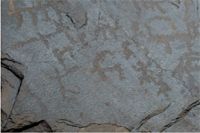
Pippula Altar (3800m) :
|
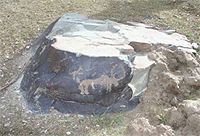
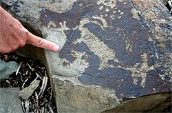
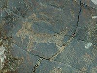
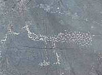
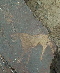
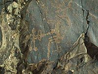
 After
crossing a stream, a small alluvial platform, on top of the Tsarap, we
can find various blocks of which about ten are engraved. One of them is
beautifully decorated and organized. Orientation east-west. The originality
of this rock is that it's the only one that I came across where I found
people in "orant" positions (both arms held up, one can imagine,
hands open and palms outstretched). On this rock, the subjects are not
only suggested but on the contrary, they seem to dance around the animals..
Seeing that there's no evident hunting scene, it immediately reminded
me of a praying altar. To the left, it could be a circling couple (or
maybe symbolically they affront each other ?). After
crossing a stream, a small alluvial platform, on top of the Tsarap, we
can find various blocks of which about ten are engraved. One of them is
beautifully decorated and organized. Orientation east-west. The originality
of this rock is that it's the only one that I came across where I found
people in "orant" positions (both arms held up, one can imagine,
hands open and palms outstretched). On this rock, the subjects are not
only suggested but on the contrary, they seem to dance around the animals..
Seeing that there's no evident hunting scene, it immediately reminded
me of a praying altar. To the left, it could be a circling couple (or
maybe symbolically they affront each other ?).
|
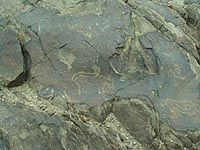
Char site (3850m)
|
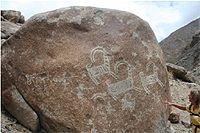
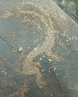
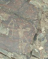
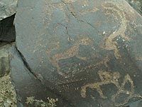
 This
is one of the riches petroglyphic sites in Zanskar and which was one of
the first to be photographed, KLODZINSKI's studies. (1) To note,
it's situated approx 1 and a half Km before the junction with the Karigiak
Chu, on the left bank of the Tsarap Zamthong. It's crossed by the main
track of the valley. One can guess through the rocks polished by the glacier,
the remnants of a very old bridge going towards the agricultural terrace
of the chariot's homestead. On these stones, which could be like a "marvellous
valley", the other area, flat, surrounded by big old land slides,
we discover hunting scenes with either walking bow and arrow men or on
horses. A lot of animals are before our eyes, snow leopards, wolves or
dogs, old he-goats, bharals or urials, but also birds and yaks. One of
these big blocks has recently been engraved with Buddhist motifs (chortens).
Other sites (Hameling, Jal, Tangse) are before or follow the great passes
of this area. This
is one of the riches petroglyphic sites in Zanskar and which was one of
the first to be photographed, KLODZINSKI's studies. (1) To note,
it's situated approx 1 and a half Km before the junction with the Karigiak
Chu, on the left bank of the Tsarap Zamthong. It's crossed by the main
track of the valley. One can guess through the rocks polished by the glacier,
the remnants of a very old bridge going towards the agricultural terrace
of the chariot's homestead. On these stones, which could be like a "marvellous
valley", the other area, flat, surrounded by big old land slides,
we discover hunting scenes with either walking bow and arrow men or on
horses. A lot of animals are before our eyes, snow leopards, wolves or
dogs, old he-goats, bharals or urials, but also birds and yaks. One of
these big blocks has recently been engraved with Buddhist motifs (chortens).
Other sites (Hameling, Jal, Tangse) are before or follow the great passes
of this area.
|
Char : A fragile and unique patrimony
|
|
|
|
In 2006, Char become a stone quarry !
|
Close to the house, in the gardens, some beautiful blocks have already
been used as stone pits. Other engravings, along the path start to undergo
recent damage (tourists and/or local people). What's really worse is the
risk of unknowing destruction of a unique and exceptional space. The Char
inhabitants walk on the engravings because they represent short cuts and
then worse still, they break these rocks to use them. They don't recognize
their value, their classification and the need of protection of the whole
site. Flat, the closest prairie is well adapted for a natural camp for
trekkers. And the worse following indications - this place is unfortunately
retained for the future road that the Indian State wants to construct
(in 5 yrs - 10 yr ???)
|
The Indus Valley
|
 The
banks of the river have been very early used as a natural and principal
means of communication. It already went for more that 500 Km from its
spring in the east over the high "Great Tibet" plains, to finally
collapse in the west between the Zanskar and Ladakh massifs. The latter
is still more dry (90 mm of water per yr) and more mineral than the opposite.
The living areas were thus set up along the mountain streams coming from
crests and the vast dejecting cones of the rivers that flow into the Indus.
The inhabitable zones serve as in between the two gravel terraces, two
tight gorges, two practically deserted zones. The volume and violence
of the flowing water have re-enforced the importance of some key points
that allow a crossing. These areas had also to be without floods. The
capital of "Little Tibet" - Leh represents all these characteristics.
Ideally situated under the Kardung pass (5300m), its situation in all
four directions, has made of its " bazaar" the unavoidable junction
for caravans coming from Central Asia, China, India, Cachemir and Tibet. The
banks of the river have been very early used as a natural and principal
means of communication. It already went for more that 500 Km from its
spring in the east over the high "Great Tibet" plains, to finally
collapse in the west between the Zanskar and Ladakh massifs. The latter
is still more dry (90 mm of water per yr) and more mineral than the opposite.
The living areas were thus set up along the mountain streams coming from
crests and the vast dejecting cones of the rivers that flow into the Indus.
The inhabitable zones serve as in between the two gravel terraces, two
tight gorges, two practically deserted zones. The volume and violence
of the flowing water have re-enforced the importance of some key points
that allow a crossing. These areas had also to be without floods. The
capital of "Little Tibet" - Leh represents all these characteristics.
Ideally situated under the Kardung pass (5300m), its situation in all
four directions, has made of its " bazaar" the unavoidable junction
for caravans coming from Central Asia, China, India, Cachemir and Tibet.
The first petroglyphic studies in this part of the Himalaya were mainly
made by Hermann FRANCKE (2). To add also those of Karl JETTMAR
(3) of the rocks situated close to Pakistan. To note is that one of
the main affluent of the legendary river, flows in this area. In the north
south part of the Hunza river, the Karokoram Hwy was completed in 19/82.
Many trucks, beautifully decorated, now replace the caravans, as well
as the army, that ever since antiquity had no other choice but to use
this natural passage between Central Asia and the Indian continent or
go over the high passes of the Himalaya.
|
There's no shortage of engravings in Ladakh
|
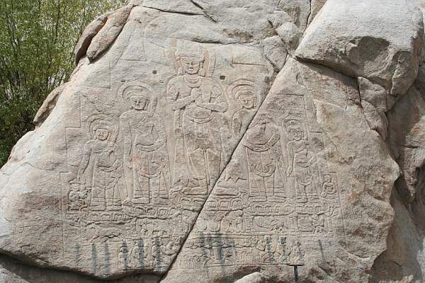
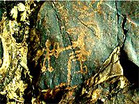
 Alchi,
known for its monastery built in the 10th century, on the left bank of
the Indus. It's classified as on of the main world art works. Totally
ignored by many tourists and its inhabitants, a magnificent collection
can be found further down on the flat surface that dominates the river.
More than 10 rocks represent remarkable scenes. Hunts of the old he goats
by men with bows and arrows accompanied by dogs, felines with striped
bodies (tigers), squares, sun wheals, lightning signs or more animals.
On some of these we sometimes find chortens, these more recent Buddhist
engravings. There too, I was surprised to notice that the concentration
of petroglyphes seemed to be organized around ancient ways. This one goes
to the only passage where a bridge could have been built. Certainly a
very risky crossing when we see what's left of the ramps of the steep
river banks. Alchi,
known for its monastery built in the 10th century, on the left bank of
the Indus. It's classified as on of the main world art works. Totally
ignored by many tourists and its inhabitants, a magnificent collection
can be found further down on the flat surface that dominates the river.
More than 10 rocks represent remarkable scenes. Hunts of the old he goats
by men with bows and arrows accompanied by dogs, felines with striped
bodies (tigers), squares, sun wheals, lightning signs or more animals.
On some of these we sometimes find chortens, these more recent Buddhist
engravings. There too, I was surprised to notice that the concentration
of petroglyphes seemed to be organized around ancient ways. This one goes
to the only passage where a bridge could have been built. Certainly a
very risky crossing when we see what's left of the ramps of the steep
river banks.
Next to Leh, Phyang, Shey, Matho, Rumtek, Umla where the archaique petroglyphes
have already been well classified (4) and Taru (5) where,
for the last 3 yrs a "Rock Park" was established. I'd like to
mention "Raptsa". Between Indus and a high pass, a lost valley.
Between abrupt bare slopes, the stream flows through a pink granite canyon,
so characteristic of Ladakh. On the side of the mule track, small rounded
blocks are decorated. The sizes, the dimensions as well as the technique,
the drawings and patinas, resemble all those already mentioned. However,
overlooking the path, on the south face of a huge rock (3m - 3m) we can
find an exceptional hunting scene. Old he goats (?) striped, are followed
by walking hunters accompanied by dogs. The petroglyphes are of big dimensions,
especially three animals ( approx. 1m x 1m each). The work seems "fresh"
(?) but still much older than the neighbouring Buddhist signs.
The captivating moments of discovery in Sept. 2005 and then with Solonge
my wife in Sept. 2006, the desire to get to know more about the authors
and period of engraving, makes me decide to do some research. Apart one
photo in a tourist guide book (6), I can't practically find any
texts or images (7) concerning the petreglyphes of Ladakh Zanskar.
Finally I find the comparative study (8) of Henri Paul FRANCFORT
(9), Reserch Director of CNRS, a joint venture with Daniel KLODZINSKI
and Georges MASCLE (10). An exceptional opening regarding the engravers
of the Bronze and Iron Age in vast Asia.
|
Prehistoric complex
|
 The
situation is complex and little research has been made in Ladakh itself.
One has thus to be careful, knowing though that prehistoric indications
confirm an ancient human occupation. (Palaeolithic and Neolithic), one
must go towards repertories of the petroglyphes themselves, concerning
dates. The
situation is complex and little research has been made in Ladakh itself.
One has thus to be careful, knowing though that prehistoric indications
confirm an ancient human occupation. (Palaeolithic and Neolithic), one
must go towards repertories of the petroglyphes themselves, concerning
dates.
When we go through the Himalayan world, one does not cesse to see, to
admire many evidences of beliefs of the Buddhist statues. Many were made
on stone. Whether we talk about the giant statue (10 m) of Mulbek or the
much smaller ones the "manis", these engraved stones which are
deposited by millions onto the prayer walls. The mastery of this technique
and intensive use of these supports ever since many centuries by local
artists, is quite obvious
By the way, it's interesting to note that the chortens and other Buddhist
engravings "superpose" the archaique petroglyphes. The latter
came thus before the introduction of this religion around the 8th century.
|
Birds
|
 Because
of the Buddhist religion of that region, they don't hunt them. More than
300 species are catalogued because other than the well adapted residential
species, this part of the Himalaya is between two climate zones which
make it an ideal place for migrating birds. However, one finds little
birds on the rocks. In an animal composition, a hunt, it seems like there
is only one (?) representation of a bird. Here a bird of prey (eagle ?)
there a partridge (?) a duck (?) and then most curiously a royal peacock
(?). Because
of the Buddhist religion of that region, they don't hunt them. More than
300 species are catalogued because other than the well adapted residential
species, this part of the Himalaya is between two climate zones which
make it an ideal place for migrating birds. However, one finds little
birds on the rocks. In an animal composition, a hunt, it seems like there
is only one (?) representation of a bird. Here a bird of prey (eagle ?)
there a partridge (?) a duck (?) and then most curiously a royal peacock
(?).
Maybe they are indicating birds ? Symbols ? Do they indicate a season
? For the researchers, the study and comparison of these birds and their
specific style, allows them to date. Photographed by KLODINSKY on the
chariot site, HP FRANCFORT dates the representation of a bird (……)
between 500 and 450 yrs B.C.
|
The Herbivores
|
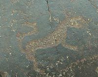
 The
old he goats came into contact with the urial and/or bhoual. The deer,
originating from Asia, is also often represented. It's a good chronicle
indication because it's a theme often produced at all times in Central
Asia. It has already been mentioned in all the rock drawings of this region.
In Ladakh today, it's till a symbol of good luck and fertility. According
to the drawing, its position, its head and other details, the researchers
can compare with other findings that have been well dated. The
old he goats came into contact with the urial and/or bhoual. The deer,
originating from Asia, is also often represented. It's a good chronicle
indication because it's a theme often produced at all times in Central
Asia. It has already been mentioned in all the rock drawings of this region.
In Ladakh today, it's till a symbol of good luck and fertility. According
to the drawing, its position, its head and other details, the researchers
can compare with other findings that have been well dated.
|
The Carnivorous
|
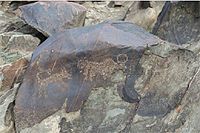
 The
felines, lynx, snow leopards, wolves or fox. If the grass eaters are identified
by the shape of their bodies, a detailed drawing of their corns, the meat
eaters are generally bigger and distinguish themselves by rays of circles
that suggest the body or the position of their tail (coiled up, straight
up, in the centre, thin or thick). The
felines, lynx, snow leopards, wolves or fox. If the grass eaters are identified
by the shape of their bodies, a detailed drawing of their corns, the meat
eaters are generally bigger and distinguish themselves by rays of circles
that suggest the body or the position of their tail (coiled up, straight
up, in the centre, thin or thick).
|
The bovines
|
 The
bovines are much less present. Does that mean that there was no breeding
then ? The yak seems to be hunted and not yet domesticated. However, it's
the most essential animal of the altitude population. Even though "relatively"
untamed, it carries loads and allows to be sat on. It climbs well and
is surer than a horse. From his meat and dung, everything's usable. The
bovines are much less present. Does that mean that there was no breeding
then ? The yak seems to be hunted and not yet domesticated. However, it's
the most essential animal of the altitude population. Even though "relatively"
untamed, it carries loads and allows to be sat on. It climbs well and
is surer than a horse. From his meat and dung, everything's usable.
|
The equidae
|
 The
most represented animals in the graving are the horses. It's never harnessed
to a chariot or other vehicle. The reproductions are of different sorts
(size, form, art graving) whether it's mounted or alone. Free in this
sense, is it still for "nourishment" or a prestigious "object".
? When mounted, its size is small, in balance with the rider and his equipment
like its arrow (N.B. the one used today is always small. It either carries
loads or a rider). (Research shows us that over 9000 yrs, the dog was
always men's companion. As for the sheep and bovines, they were domesticated
more than 5000 yrs ago. The horse, for a long time, represented nourishment,
furnishing "materials" and, who knows, producer of milk. Certainly
more difficult to capture, to control and train, it had to find its place
in our surroundings only 3000 and 5000 yrs ago. All these dates vary of
course according to each region of the world. On the mountains and in
deserted zones, the known wheal is of little use for transport because
of the difficult terrains.) (Yaks, lamas, camels, horses and other animals
carry.)gorie, l'animal le plus fréquemment représenté
dans les gravures est le cheval. Il n'est jamais attelé à
un char ou un araire. Les reproductions sont de factures différentes
(taille, forme, piquetage) lorsqu'il est dessiné monté ou
libre. Libre, dans ce cas est-il encore " nourriture " ou "
objet " de prestige ? Monté, sa taille est petite, cohérente
avec celle de son cavalier, celle de son équipement comme l'arc
(N.B. celui utilisé actuellement est toujours petit, Il porte soit
une charge soit un cavalier). (Les recherches nous indiquent que depuis
bientôt 9000 ans, le chien a été le " collaborateur
" puis le compagnon de l'homme. Quant aux ovins et aux bovins, ils
ont été domestiqués il y a plus de 5000 ans. Le cheval
lui est resté très longtemps nourriture, fournisseur de
" matériaux " et à la rigueur producteur de lait.
Certainement plus difficile à capturer, à maîtriser
puis à dresser, il a du trouver sa place dans notre environnement,
il y a seulement entre 5000 et 3000 ans. Toutes ces dates varient bien
sûr, suivant les régions du monde. Dans les zones de montagnes,
les déserts, la roue qui est connue, est de peu d'intérêt
pour les transports en raison des difficultés du terrain).(Yacks,
lamas, chameaux, chevaux et autres animaux portent…. The
most represented animals in the graving are the horses. It's never harnessed
to a chariot or other vehicle. The reproductions are of different sorts
(size, form, art graving) whether it's mounted or alone. Free in this
sense, is it still for "nourishment" or a prestigious "object".
? When mounted, its size is small, in balance with the rider and his equipment
like its arrow (N.B. the one used today is always small. It either carries
loads or a rider). (Research shows us that over 9000 yrs, the dog was
always men's companion. As for the sheep and bovines, they were domesticated
more than 5000 yrs ago. The horse, for a long time, represented nourishment,
furnishing "materials" and, who knows, producer of milk. Certainly
more difficult to capture, to control and train, it had to find its place
in our surroundings only 3000 and 5000 yrs ago. All these dates vary of
course according to each region of the world. On the mountains and in
deserted zones, the known wheal is of little use for transport because
of the difficult terrains.) (Yaks, lamas, camels, horses and other animals
carry.)gorie, l'animal le plus fréquemment représenté
dans les gravures est le cheval. Il n'est jamais attelé à
un char ou un araire. Les reproductions sont de factures différentes
(taille, forme, piquetage) lorsqu'il est dessiné monté ou
libre. Libre, dans ce cas est-il encore " nourriture " ou "
objet " de prestige ? Monté, sa taille est petite, cohérente
avec celle de son cavalier, celle de son équipement comme l'arc
(N.B. celui utilisé actuellement est toujours petit, Il porte soit
une charge soit un cavalier). (Les recherches nous indiquent que depuis
bientôt 9000 ans, le chien a été le " collaborateur
" puis le compagnon de l'homme. Quant aux ovins et aux bovins, ils
ont été domestiqués il y a plus de 5000 ans. Le cheval
lui est resté très longtemps nourriture, fournisseur de
" matériaux " et à la rigueur producteur de lait.
Certainement plus difficile à capturer, à maîtriser
puis à dresser, il a du trouver sa place dans notre environnement,
il y a seulement entre 5000 et 3000 ans. Toutes ces dates varient bien
sûr, suivant les régions du monde. Dans les zones de montagnes,
les déserts, la roue qui est connue, est de peu d'intérêt
pour les transports en raison des difficultés du terrain).(Yacks,
lamas, chameaux, chevaux et autres animaux portent….
|
The Personalities
|
 The
subjects are small and even if the sizes stay the same, they are generally
smaller than those of the hunted animals. On foot, they are well placed
upon their legs, the masculine sex very evident. Sometimes he seems to
be dressed with a long coat similar to the traditional masculine clothes
of the high areas. Even if the "goncha" Ladakhi or the Tibitan
"chuba" can't be mistaken for a feminine garment which has a
corset or a large belt, one must note that the Normans Chang Pa, men or
women's clothing, both wear the same long garment called paska. On a horse,
he always looks armed and in a hunting position. The
subjects are small and even if the sizes stay the same, they are generally
smaller than those of the hunted animals. On foot, they are well placed
upon their legs, the masculine sex very evident. Sometimes he seems to
be dressed with a long coat similar to the traditional masculine clothes
of the high areas. Even if the "goncha" Ladakhi or the Tibitan
"chuba" can't be mistaken for a feminine garment which has a
corset or a large belt, one must note that the Normans Chang Pa, men or
women's clothing, both wear the same long garment called paska. On a horse,
he always looks armed and in a hunting position.
|
The Attributes
|
 The
bow and arrow : The one reproduced here, is small and seems identical
to the rider or walking man. It's very big and here too, it seems to be
of homogenised size with its user. (A big bow and arrow is not used when
riding). The
bow and arrow : The one reproduced here, is small and seems identical
to the rider or walking man. It's very big and here too, it seems to be
of homogenised size with its user. (A big bow and arrow is not used when
riding).
According to this fact, it can be considered to be the "little"
arrow (90 cm to 1m20) well known in those times. Very much used all over
because of its easy functioning and its easy fabrication with local materials.
 Robust
and less precise, it will evolve to the "composite" arrow (also
called "Asiatic") which is an assembly of wooden planks, bone
and tree coarse. A new improvement will produce a model where the extremities
are rounded up towards the front. Robust
and less precise, it will evolve to the "composite" arrow (also
called "Asiatic") which is an assembly of wooden planks, bone
and tree coarse. A new improvement will produce a model where the extremities
are rounded up towards the front.
A deathly weapon : All these versions are always used by the inhabitants
in competition or ritual celebrations that particularly mark spring. (12).
The ritual of the arrow can be found in myths, in the names (13).
The name Dah (translated by arrow) is the name of a village close to the
Indus in lower Ladakh. The Brogpas, who live there, still sculpt old he
goats on schist plates. The arrow can also be found in the power symbols
of the kings of Ladakh and Zanskar (on the contrary to spears, blades,
axes).
The bulk of the weapon :
Much more difficult to identify on the rocks - the bulk of the weapon
is represented at the belt or held up. This weapon is common in the petroglyphes
of Central Asia. It's characteristic of the Bronze Age of this region.
|
Dating
|
 The
precise dating is up to specialists. For now, we can use the reference
of the preliminary study which was published by HP FRANCFORT and his colleagues.
They proved that some engravings, specific in style and iconography, could
be related to Central Protohistoric Asia (Bronze and Iron Age, i.e. 2500
and 500 BC) Threatened to disappear, however luckily, the rock drawing
art of Ladakh and Zanskar, has for the last years become an object of
interest and various studies. Laurianne BRUNEAU (14) is preparing
a theses on rock drawings art in Ladakh Zanskar. She hopes that the interpretation
of data will allow to understand the role played by Ladakh Zanskar at
different times between India, Tibet, China and Central Asia. The
precise dating is up to specialists. For now, we can use the reference
of the preliminary study which was published by HP FRANCFORT and his colleagues.
They proved that some engravings, specific in style and iconography, could
be related to Central Protohistoric Asia (Bronze and Iron Age, i.e. 2500
and 500 BC) Threatened to disappear, however luckily, the rock drawing
art of Ladakh and Zanskar, has for the last years become an object of
interest and various studies. Laurianne BRUNEAU (14) is preparing
a theses on rock drawings art in Ladakh Zanskar. She hopes that the interpretation
of data will allow to understand the role played by Ladakh Zanskar at
different times between India, Tibet, China and Central Asia.
|
Location
|
 Over
more than 4000 yrs, in the high massifs of the Himalaya, important signs
(could ?) indicate itineraries along the "easiest" crossings. Over
more than 4000 yrs, in the high massifs of the Himalaya, important signs
(could ?) indicate itineraries along the "easiest" crossings.
We can mention for eg., between Mongolia and Pakistan, the Gilgit rocks
(15) on the banks of the Hunza which twits itself a passage between
the summits of the Karakoram and the Hindu Kush. In Nepal, the stones
of the Kak Nyinba (Kagbeni) (16) occupy the Kali Gandaki banks.
It rolls its pebble from the Tibetan Mustang towards the Indian Gange
at the bottom of the biggest break of the world, between 8000m of the
Annapurnas and the Dhaulagiri. However, I've also noticed that the decorated
stones seem to multiply themselves in zones close to difficult passages
: gorges, passes and water crossings like the Chariot or at Alchi. A flat
space, a platform, & possibility found on the baks of the Doda, the
!tsarap (becoming Zanskar after Padum) just like on the banks of the Indus
at Khatse, at Dah or even further (in Pakistan) in China. So what is the
nature of these sites ? The marking of paths, hunting ground, itineries
towards prairies or more waiting zones, a sacred space, territory limitation
? And the engravings, are they marked with prestige, prayers or thanks
? It's up to research to let us get to know better the men of their origin.
 I
can still see our Cachmiri driver who took us over the flooded bridge
of the Doad. Other drivers had given up, trucks sank but he negotiated
skilfully a scary passage with his car. When we got back inside, he takes
a brush and red paint. With his big smile he explains to us that he's
going to write his name on a close by rock to mark his adventure. Next
to all these wonders, all the questions that can be discovered concerning
the Ladakh Zanskar rocks is the answers of the future of the archaeological
witnesses that surprise me most ! I
can still see our Cachmiri driver who took us over the flooded bridge
of the Doad. Other drivers had given up, trucks sank but he negotiated
skilfully a scary passage with his car. When we got back inside, he takes
a brush and red paint. With his big smile he explains to us that he's
going to write his name on a close by rock to mark his adventure. Next
to all these wonders, all the questions that can be discovered concerning
the Ladakh Zanskar rocks is the answers of the future of the archaeological
witnesses that surprise me most ! 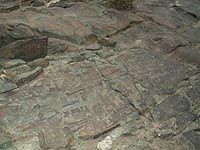 To
make them known, is also a means of conservation. To mention them to passing
tourists or to show them, is not enough. It's actually sometimes a risk
when the visitor, because of negligence, without knowledge, lack of precaution,
non respect of the rules - even worse - stupid action, damages this unrepairable
heritage. Often, tourists' actions end up in a worse accelerated destruction.
The protection of the "Char" - Chariot, site goes first and
foremost through the local population. The conscious knowledge of the
specific value of the engravings is an immediate priority. It's part of
their history, their ancestors, an inheritance and to be transmitted because
they've become the great guardians. Just like mythical snow leopards,
these engraved rocks are worth all the protection. The remarkable initiatives
already taken to make the population sensitive, the local authorities,
national and world wide, educate the guides and other accompanying people,
are the main means that assure the conservation of this fragile and unique
patrimony. May these few lines be of some help.. To
make them known, is also a means of conservation. To mention them to passing
tourists or to show them, is not enough. It's actually sometimes a risk
when the visitor, because of negligence, without knowledge, lack of precaution,
non respect of the rules - even worse - stupid action, damages this unrepairable
heritage. Often, tourists' actions end up in a worse accelerated destruction.
The protection of the "Char" - Chariot, site goes first and
foremost through the local population. The conscious knowledge of the
specific value of the engravings is an immediate priority. It's part of
their history, their ancestors, an inheritance and to be transmitted because
they've become the great guardians. Just like mythical snow leopards,
these engraved rocks are worth all the protection. The remarkable initiatives
already taken to make the population sensitive, the local authorities,
national and world wide, educate the guides and other accompanying people,
are the main means that assure the conservation of this fragile and unique
patrimony. May these few lines be of some help..
|
Precisions
|
A. Orans : This terminology is usually used in a special context,
those of Christian art. It represents a human figure that's praying, arms
held up, or a funeral statue representing a praying person on knees.
B. the Animals : It's difficult to distinguish the animals. Forms,
lengths, space between the corns can be a means to distinguish the old
he goats (Capra ibex siberica). It's more difficult to make the difference
between the Bharal (Pseudois nayaur) (the blue English sheep) and Urial
(Ovis vignei vignei).
C. the Dzo is the hybrid between the yak and the cow, the yak
female is called Dri and produces milk … yak milk.
D. the Supports : a chronological repertory : just like nature,
the shape of the engraved rocks, the colours are important. Therefore,
some rocks are "rounded" and of "dark brown". This
patina, called " the desert's varnish" is very intense and well
conserved on the crystalline rocks because of the previous glacier conditions.
Studies that were undertaken on the moraine deposits allowed to establish
a chronology relating the variations of the glaciers whereas other engraved
rocks can be found on blocks with sharp edges. They seem to be more recent
with little or no patina.
E. The Dimensions Except for the huge Rapsta rock (3m x 3m) and some of
the big ones of the Char, the size of the engraved rocks are rather 1m
x 1m or less. The accessibility and the position of the engravers, are
comfortable. The size of the subject is generally modest 5 to 10 cm).
F. the Drawing : It's either indicated only by an outline or the
subject can also be totally filled up. One could distinguish a third family
where the inside of the drawing was scratched, decorated with dots or
circles.
G. The technique : Percussion (dots) by small impacts with a tool
like an etcher's needle of hard stone (quartz ??) or maybe metal ?
H. The domestication of the horse : The Kirghize horse is only
one and half meters high at the wither, its neck and withers are large
and he's well adapted to the mountains. It's essential to the wandering
tribes of Kirghizstan.
I. The Brogpas : called by some "aryens". A lower groupe
of the population called "Dardes". A part of the "aryens"
people who speak or have spoken the Indo - Iranian language. Their origin
"aryenne ? " "Descendants" from Alexander the Great
soldiers ?? Animists before being Buddhists. What is certain is that physically
they are very different from the other ethnics of Ladakh Zanskar and that
the ethnologies still have a lot of research to do.
J. Dates : In all of Central Asia, there are lots of petroglyphes
very rich. (Ljangar, Saymal-Tash, Tamgaly..) These groupings also represents
"panels" of horse riders, hunting scenes, animals. The researchers
go back as far as the Bronze Age in their chronology. (more than 5000
engravings discovered in Tamglay at Kazahstan have, in this way, been
dated in the second half of the second millenary B.C. up to the beginning
of the XXth century.)
K. Glances : Mongolia, Tadjistan, Kirghistan, etc… the petroglyphic
images immediately remind us of those found in Ladakh Zanskar.
|
Rules
|
It seems obvious not or walk
on graved scenes just like not using sticks nearby. A little more
supple, don't through water onto them (which makes the "rocks
crack") to take a photo.
Draw a little Mickey or the initials, try to tear one away or
bring a piece of rock with you , are stupid gestures, dramatic
and irresponsible.
|
|
Bibliography
|
(1) D. KLODZINSKI 1982: * Rupestral engravings in the Himalayas
- Zanskar * - Bulletin of the Literary and Scientific Survey firm of the
Batch.
(2) A H. FRANCKE: Work and discovered of 1902 to 1925
(3) K JETTMAR and THEWALT V (1987): * Rocks engraved along the
high road of Karakorum - Mainz - Philipp von Zabern and also K JETTMAR:
Work since 1982. In 1989 publishes: * inscriptions on the rocks in the
valley of Indus - Mainz - Philipp von Zabern
(4) Martin SLIDING GAUGE, indexed to date more than 10 000 engravings
distributed on a hundred rupestral sites: http://www.fcmm.org Ladakh project.
(5) Creation on the initiative of S.D. JAMWAL http://www.himalayanaffairs.org
with an aim of protection of blocks remarkable (in place or brought back)
http://www.highasialadakh.com
(6) Photograph of a " rock engraved " in Zanskar page
48 of * Large Guide GALLIMARD of India of the Western North (2001) (7)
Photo of a scene of battle (?) page 183b PEISSEL. * The Kingdoms of the
Himalayas ED BORDERED (1986)
(8) Henri Paul FRANKFURT, Daniel KLODZINSKI, George MASCLE. * 1990,
antiquated Petroglyphs of Ladakh and Zanskar, Asian Arts, Yearly Volume
XLV. of the national Museum of Asian Arts - GUIMET and museum CERNUSCHI
(9) Henri Paul FRANKFURT: Director of research at the Directing
CNRS of the MAFAC (French Archaeological Mission in Central Asia): writings
in particular of 1990 to 1997 like: * Petroglyphs I and II at the age
of bronze " http//www.diplomatie.gouv.fr.
(10) G MASCLE: Photographs and statements in Zanskar (Choktsi)
(11) Réf: DOLFUS: P. 1988, " the representation of
the ibex in Ladakh, area of culture tibétaine of India of North
", Tibetan Studies P roceedings of the 4th seminar of the International
Association of Tibetan Studies - Munich 1985, Band II, Uebach, H./J.L.
Panglung (dir.), p.125-138.
(12) Olivier FÖLLMI reports a ritual at the village of Ichar
(at one day of walk of Tank) page 91. * So far from the Men, so close
to the Gods. Editions Martinière 1998
(13) the House of Himalayas (Association 1901) http:
/ / www.maisondeshimalayas.org
(14) Laurianne BRUNEAU which I thank. Member of the team of H.
P. FRANKFURT in collaboration with Messrs JAMWAL and SLIDING GAUGE, it
continues on the ground his study on " the petroglyphs of the Himalayas
Occidental " and prepares his thesis. Prize winner of purse SCHNEIDER
- Louis FOREST (Letter and Social sciences).
(15) http://www.blankonthemap.free.fr
(16) Dr. Perdita POHLE: Enquiring http//.www.uni-giessen.de/geography
* Petroglyphs have elements of the farming landscape of Mustang.
...not to forget the maps made by Olizane edition et le
livre Ladakh Zanskar de Charles Genoud and Philippe Chabloz.
Texts & pictures
© Christian CHABERT
CC/SCV 10/2007 - All rights reserved
|