|
||||||||||
|
|
||||||||||
|
|
|
|||||||||
 Interactive map Batura area (57 ko) |
||||||||||
Pute towers Group -~c5,880-: |
||||||||||
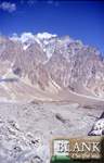
A mixed nationality team of Tom Goodwin and Pete Scott from New Zealand, Johan 'Sugar' Gouws from South Africa and Sam Stacey plus Peter Thompson from the UK visited the fine granite spires of the Pute Towers, which form the extension of the South Ridge of Hachindar Chhish (7,163m) north of Aliabad in the Hunza Valley. The team set up Base Camp on the Yain Hisk pasture in early July after a three day approach from the Karakoram Highway via the Muchuhar Glacier. Subsequently, they spent 42 days in the region, experiencing only 11 or so days of bad weather but rather more on which snow conditions were considered dangerously unstable. |
||||||||||
Third Tower -~c5,800m- : |
||||||||||
The team made the first ascent of the Third Tower (5,800m: the second highest of the group) via a long east-facing gully above the Yain Hisk pasture, followed by the crest of the South Ridge, which consisted of snow slopes interspersed with steep mixed rock pitches. They were denied access to the Second and highest Tower, which lies just to the north, by difficult terrain and deteriorating weather. |
||||||||||
Sakar Sar -c6,272m - |
||||||||||
This remote 6,272m peak in the northern Batura Muztagh received its
first ascent in August by all four members of a Japanese expedition,
Miyazawa Akira (leader), Ishikawa Makoto, Kamei Kanji and Suzuki Teruaki,
together with Alam Jan and Anwar Khan from Pakistan. The peak lies on
the Afghan border (Wakhan Corridor) and is accessed via the Sakarjerab
Valley, which runs down to the long Chapursan Valley not far below its
head at the Chillinji An (c5,290m).
|
||||||||||
Sangemarmar Sar -c6,949m (c7,050m)- : |
||||||||||
|
||||||||||
Sani Pakush -c6,885m-: |
||||||||||
This fine pyramidal peak, which lies north of Chalt on the watershed
between the Kukuay and Batura Glaciers, has only been ascended once,
by a German team who climbed up and down the North West Ridge in 1991.
|
||||||||||
First & Second Tower : |
||||||||||
The First Tower was climbed in early August and involved 800m of mixed
and pure rock with pitches up to VI (British HVS). It was descended
in 16 rappels. The Second Tower was shorter but started with a pitch
of British E1 5b.
|
||||||||||
Third Tower : |
||||||||||
On the third day all four reached the base of the Third Tower. The
morning of the fourth day dawned with ominous cloud cover but they set
off, climbing five mixed and rock pitches up the only feasible line
(which necessitated a bold lead up a poorly protected pitch at E3 5c)
until rockfall from above cut one of the ropes. This incident, together
with other rock fall incidents and the difficult, compact terrain that
could not be aided or avoided if the weather broke, persuaded them to
descend. The decision proved wise, as over the following two days, while
they descended to Base Camp, a storm moved in depositing half a metre
of snow. The high point at c5,600m was just 400m short of where the
buttress joins the South Ridge, above which an 800m ascent over 35°
snow with several mixed pitches appeared to lead directly to the summit.
|
||||||||||
Shani Peak -c5,800m- (Naltar valley): |
||||||||||
|
||||||||||
Shani Peak -c5,800m-, East summit : |
||||||||||
|
||||||||||
Shani Peak -c5,800m-, South East face : |
||||||||||
On the 20th August and on the opposite side of the mountain van der
Gragt and Netelenbos attempted the South East Face of the Main Summit.
After several notable British attempts in the '80s, this side of the
peak was eventually climbed in 1989 by Duncan Francis, Peter Leeming
and Martin Oakes. The Dutch line lay very close to the 1989 British
Route, climbing the rock buttress to the left in the lower part of the
face, then continuing more directly in the upper section to the summit.
On the first attempt the two Dutch failed at around half-height, caught
in the same storm that severely hampered their team-mates on the North
East Spur. On the 29th-30th August they made a second attempt and reached
the summit after just 15 hours climbing and one bivouac. The initial
rock pillar gave excellent climbing on 'Chamonix-like' granite, mainly
IV and V with a crux section of VI and a wet slabby pitch of V+ on the
right flank of the crest near its top. The pair then climbed through
mixed ground and a rocky section called the Fortress (V) to a bivouac
on the Central Snowfield at around 5,220m. Next day they climbed directly
to the main summit via the snowfield and a hidden couloir with a section
of 80°. It took 12 hours to descend the West Ridge and return to
Base Camp. Next day, the 31st, Amons and Redeker also reached the summit
via more or less the same route, having started on the 30th. This pair
made an important variant (V+) on the left side of the crest of the
rock pillar to avoid the crux section climbed by the previous party.
The 1,600m route was thought to be TD/TD+.
|
||||||||||
Shispare -c7,611m-: |
||||||||||
|
||||||||||
Snow Dome -c5,322m- (Sentinel Peak - Naltar valley) : |
||||||||||
Halsten and Morgan, together with two other British climbers, made an ascent of the popular 5,030m Snow Dome to the east, Morgan largely on ski. The team report somewhat quarrelsome porters used to access this beautiful but nowadays somewhat frequented Alpine valley and were subjected to a little theft on the approach. During acclimatization, Andreas Amons, Elwin van der Gragt, Benno Netelenbos and Melvin Redeker climbed the popular Snow Dome, Sentinel Peak and the lower Sentinel North (at AD), the latter measured at 5,322m and first ascended in 1984 by Dick Renshaw and Stephen Venables after an unsuccessful attempt on Shani's still unclimbed lower South Pillar; the true crest of the ridge left of both the 1999 Dutch and 1989 British starts. During this early period the Dutch report that their Base Camp was robbed one night, forcing them to hire an armed guard. Thereafter, and perhaps not surprisingly, relations with the local inhabitants became a lot more cordial. |
||||||||||
Sumaiyer Peak -c5,520m- : |
||||||||||
During August, 25-year old David Larrión climbed a series of routes on peaks relatively close to the Karakoram Highway. Early in the month with Ager Madariaga he made the probable first ascent of the East Ridge of Pt 5,520m on the watershed between the Sumaiyer and Nagar Valleys. Although the Spanish pair refer to this as Sumaiyer Peak, it was originally christened Peak Dawson by the British first ascensionists who climbed from the Sumaiyer Valley in 1979. The true Sumaiyer Peak lies directly opposite Peak Dawson on the west side of the lower Silkiang Glacier and was climbed via the East Buttress (again by British) in 1984. |
||||||||||
Tpopdan Sar (Tupopdan)-c6,106m- : |
||||||||||
|
||||||||||
Ultar (Death Peak) -c7,388m- : |
||||||||||
|
||||||||||
Ultar (7388m), South East pilar : |
||||||||||
|
||||||||||
Ya Chhish -c5,130m- : |
||||||||||
He climbed the fore summit of Ya Chhish (5130 m), located exactly
in front of the face, to take a good look at the coming Batura climbing
route, from base to summit. Ya Chhish was climbed May 23 1976 by two
German climbers.
|
||||||||||
Yeti Sar -c5,980m- : |
||||||||||
The 29th August 1998, the mountain received its first ascent by four
Germans from the Dresden region. Jörg Ehrlich, Frank Polter, Dieter
Ruelke and Markus Walter first established Base camp at Karambar Ilag
(3,300m), then made a high Camp by a glacier lake in the Kutshkulin
Valley at 4,300m. Ruelke and Walter set off at 4am to climb another
snowy peak at the head of the glacier. Christened Yeti Sar, this 5,980m
mountain was ascended via 15 pitches of straightforward 50° ice
but the two climbers had a narrow escape when a huge corniced section
of summit ridge collapsed just five metres in front of them. At least
it allowed an excellent view northwest to the high peaks of the Pamir.
All four were back in Gilgit by jeep on the 1st October.
|
||||||||||
Sources :All informations mainly coming from,
|
||||||||||
|
See also the same
topics pages :
|
||||||||||
|
Révision D - july 06th 2007 (http://blankonthemap.free.fr) Home
- History
- Geography
- local life
- Travelling
- Forums
- Gallery
- Links
- Index
- About Blank
var pagename='Page_map_russes'; For more details, contact the Webmaster |
||||||||||

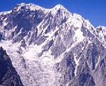 The
summit of Sangemar Sar is located on the South ridge of the Batura Wall
wha separate the Muchuhar & Shispare glacier. This summit is considerate
as the " crystal " of the Baltit oasis.
The
summit of Sangemar Sar is located on the South ridge of the Batura Wall
wha separate the Muchuhar & Shispare glacier. This summit is considerate
as the " crystal " of the Baltit oasis. Several
British teams visited this easily accessible valley off the Karakoram
Highway just north of Gilgit. There have now been a considerable number
of small expeditions to Shani and its surrounding peaks, the majority
of British origin and more than a handful to attempt the true North
Face. This somewhat vast, technically difficult and objectively dangerous
face, which was probably first brought to public notice after its picture
appeared in Trevor Braham's autobiographical classic, Himalayan Odyssey,
remains the major prize on this easily accessible mountain. The four
man group of Martin Cooper, Charles Halsten, Jonathan Morgan and Nick
Wallis made a probable third ascent of Shani's West Ridge, the route
of the first ascent in August 1986 by Roger Everett and Guy Muhlemann
of this shapely 5,800m peak towards the head of the valley.
Several
British teams visited this easily accessible valley off the Karakoram
Highway just north of Gilgit. There have now been a considerable number
of small expeditions to Shani and its surrounding peaks, the majority
of British origin and more than a handful to attempt the true North
Face. This somewhat vast, technically difficult and objectively dangerous
face, which was probably first brought to public notice after its picture
appeared in Trevor Braham's autobiographical classic, Himalayan Odyssey,
remains the major prize on this easily accessible mountain. The four
man group of Martin Cooper, Charles Halsten, Jonathan Morgan and Nick
Wallis made a probable third ascent of Shani's West Ridge, the route
of the first ascent in August 1986 by Roger Everett and Guy Muhlemann
of this shapely 5,800m peak towards the head of the valley.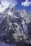 A
four-man Dutch Shani Expedition (Andreas Amons, Elwin van der Gragt,
Benno Netelenbos and Melvin Redeker) completed two new routes on this
impressive 5,885m peak in the Naltar Valley. On the 22nd August, Amons
and Redeker reached the lower East Summit, which registered c5,610m
on their altimeter, after having made the first ascent of the 1,000m
high North East Spur. The two climbers spent a full four days on the
mountain due to poor weather, bivouacking on the East Top for 33 hours
in a hail storm before rappelling and down-climbing the line of ascent.
They had originally hoped to traverse all the summits of Shani and descend
via the Original Route on the West Ridge climbed by Roger Everett and
Guy Muhlemann in 1986. Although the foot of the spur is relatively close
to Base Camp at Upper Shani (3,920m), the icefall of the Shani North
Glacier bars direct access. Instead, a circuitous 10-hour approach has
to be made, at first northwest towards the Pakhor Pass then back across
the glacier. After an initial gully, the route on the Spur followed
a snow ridge, breaking through the rock buttress above via a narrow
70° ice gully. In the upper section the pair were forced off the
crest due to appalling rock and made a rising traverse towards the edge
of a serac barrier, where they found excellent granite. They climbed
this good rock to a false top at c5,400m and then continued more easily
up 50° snow to make the first ascent of the East Top. An overall
Alpine grade of TD (V and 65/70°) was quoted. The party felt that
more snowy conditions would reduce this grade.
A
four-man Dutch Shani Expedition (Andreas Amons, Elwin van der Gragt,
Benno Netelenbos and Melvin Redeker) completed two new routes on this
impressive 5,885m peak in the Naltar Valley. On the 22nd August, Amons
and Redeker reached the lower East Summit, which registered c5,610m
on their altimeter, after having made the first ascent of the 1,000m
high North East Spur. The two climbers spent a full four days on the
mountain due to poor weather, bivouacking on the East Top for 33 hours
in a hail storm before rappelling and down-climbing the line of ascent.
They had originally hoped to traverse all the summits of Shani and descend
via the Original Route on the West Ridge climbed by Roger Everett and
Guy Muhlemann in 1986. Although the foot of the spur is relatively close
to Base Camp at Upper Shani (3,920m), the icefall of the Shani North
Glacier bars direct access. Instead, a circuitous 10-hour approach has
to be made, at first northwest towards the Pakhor Pass then back across
the glacier. After an initial gully, the route on the Spur followed
a snow ridge, breaking through the rock buttress above via a narrow
70° ice gully. In the upper section the pair were forced off the
crest due to appalling rock and made a rising traverse towards the edge
of a serac barrier, where they found excellent granite. They climbed
this good rock to a false top at c5,400m and then continued more easily
up 50° snow to make the first ascent of the East Top. An overall
Alpine grade of TD (V and 65/70°) was quoted. The party felt that
more snowy conditions would reduce this grade. The
Polish/German team of J.Kurczab climbed Shispare in 1974 by its South/East
edge. The route : From the Passu glacier to the Northern edge (2 km),
then cross a vast plateau (6700m approx.). Then, the route is diverted
and, at the beginning, difficult (4 high camps, the last at 6700m).
The
Polish/German team of J.Kurczab climbed Shispare in 1974 by its South/East
edge. The route : From the Passu glacier to the Northern edge (2 km),
then cross a vast plateau (6700m approx.). Then, the route is diverted
and, at the beginning, difficult (4 high camps, the last at 6700m).
 Tupopdan
mean the " mouthful of sun mountain " in local language, good
name decause it's ful red colours at the sunset. Tpopdan peak dominate
the wondefull Passu Cathedrales. In 1987, Tpopdan Sar was climb by British
P.Cox, L.Griffin et M.Woolridge, who traced a beautifull and hard route
2000 meters high.
Tupopdan
mean the " mouthful of sun mountain " in local language, good
name decause it's ful red colours at the sunset. Tpopdan peak dominate
the wondefull Passu Cathedrales. In 1987, Tpopdan Sar was climb by British
P.Cox, L.Griffin et M.Woolridge, who traced a beautifull and hard route
2000 meters high. The
suffixe " tar " in burushaski mean " summer pasture ",
Ultar is the " mountain of the pasture ".
The
suffixe " tar " in burushaski mean " summer pasture ",
Ultar is the " mountain of the pasture ". A
four-member French expedition comprising Jerome Blanc-Gras, Erwan le
Lann, Christophe Profit and Hervé Quallizza were unsuccessful
during May/June on their project to ascend the giant c3,600m-high South
East Pillar of Ultar (7,388m). This pillar, similar to three times the
height of the Walker Spur, has been attempted only once previously (by
Japanese).
A
four-member French expedition comprising Jerome Blanc-Gras, Erwan le
Lann, Christophe Profit and Hervé Quallizza were unsuccessful
during May/June on their project to ascend the giant c3,600m-high South
East Pillar of Ultar (7,388m). This pillar, similar to three times the
height of the Walker Spur, has been attempted only once previously (by
Japanese).