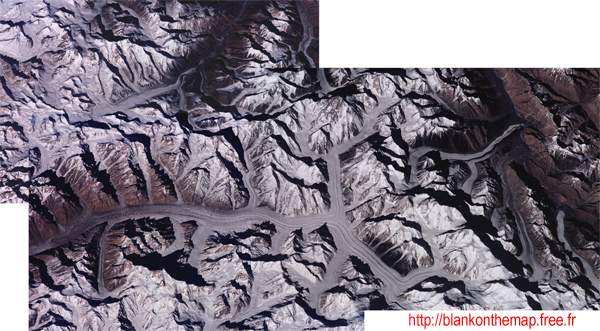
This extraordinary satellite image has been reconstructed
with the help of three others. This landscape represents the amphitheater
of the Karakoram, world wide known for its high mountaineering. One
can see there the Baltoro and Sargo Laggo basins as well as the Mutstagh
passes through which went the biggest explorers like Conway or Erik
Shipton. The Sarpo Laggo basin (in China) is unfortunately prohibited
whereas the Baltoro basin (Pakistan) is visited every year by hundreds
of tourists. Please note that at the top of the image, one can distinguish
the image of the crevassed glacier that Erik Shipton went through in
1939 - he went all the way up to the foot of Skamri Peak ("the
Fangs") and then further to the Snow Lake basin. One can clearly
distinguish the K2 pyramid which only the Broad Peak can equal in stoutness,
the Gasherbrun and the Masherbrun group. The Trango tower "Eternal
Flame" projects a gigantic shadow onto the ground in the K2's direction
whereas the Muztagh tower looks after this holy composition.
Available formats :
Zoom X2
Zoom X3