This satellite image is extraordinary, the Batura wall makes sense.
The Batura mountain chain (Batura Muztagh) which regroups some of
the most important mountains of the world, raises strongly from its
eastern base, literally collapsing into the Hunza valley where the
small town of Karimbad can be found (invisible on the map). The Baltura
glacier, 58 Km long and fifth biggest glacier of the area, runs out
before the north of this mountain range and then dies in the Hunza
river by forming a curious final elbow. One can imagine the impressing
summit of the north slope called "The Wall" (in the shadow).
|
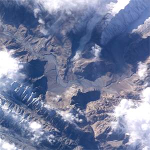
This satellite image represents the Hunza valley
at the Passu level at the junction of the Passu glacier (on the
top, in the middle) and the Batura glacier (top right), as well
as the Shimshal valley at the bottom of the photo. The experts might
surely notice the road of the Karakoram Hwy at the bottom of this
great valley so distorted by rocks and the moraines from the neighbouring
glaciers.
|
||
|
Available sizes
:
Zoom X2
Zoom
X3 Zoom X3
 |
Zoom
X3 Zoom X3
 |
||
|
From Nasa web site (http://eol.jsc.nasa.gov)
|
|||
See other maps about Batura area :To the same topic : |
|||

var pagename='Page_picture_sat_batura'; For more details, contact the Webmaster |