|
|
HANG-GLIDING
IN KARAKORAM
- Page 2/2 -
|
|
|
|
|
|
|
|
|

|
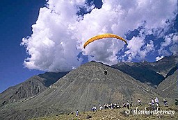
September 4th 2005, Gilgit-Baghulti, 120 kms :
|
 |
|
Flying over an unkhnown summit
|
Deep blue sky and haze down in the valley. Is it the best conditions
to start a cross-country flight? Julien and I are asking ourselves before
taking off for another month of adventure. We are planning this time
a bivouac circuit from Gilgit to Chitral, through the Karakorum and
Indu Kuch. A trip of just above 500 kms involving the crossing of several
passes at more than 5000.
That is why we have deliberately chosen September, between monsoon and
autumn, when there should be less snow at high altitude. Remember that
if the weather conditions are not suitable, we will have to cross on
foot. Bad news. It is too stable and we are struggling to get any height.
We took off at 2500 meters and we have to fight for an hour to reach
4000 meters, the minimum altitude needed to leave Gilgit. Once pressing
hold on the first edges, the thermals are getting stronger and stronger
and here we are after a few turns at 6000m. Time to start our trip!
Not so easy to fly at 6000 meters, just three days after suffocating
in the moist air of Rawalpindi. I am trying not to go too high, to fly
fast and to stay close to the ridges on this highway to cloudbase. When
we studied the maps, it seemed obvious to follow the valley of the Gilgit
river up to the Indu Raj range. And it works. We fly above amazing diverse
landscapes: glaciers, rocky deserts, lava flow and suddenly, hiding
behind a ridge, a huge sand dune at 5000m of altitude! We land in the
shadow of the massive Dhulis Shish mountain (6500m), in the Darkot valley,
just at the foot of the Indu Raj range. Here start the real troubles…
Upon our arrival, we are greeted by a lively crowd and are taken to
the best house in the village. The locals treat us like kings and offer
us food and shelter, just what we need to forget our weariness after
breathing rarefied air for hours. But, as it is time to sleep, we are
requested to answer urgently the only phone working in the village.
On the other end of the phone, an overexcited policeman who saw us 20
kms ago firing questions at us :
|
|
|
Far west landscape on the same
route
|
- "Where do you come from?
- Gilgit, in 5 hours of flying!
- What? But it is unbelievable!
- Why didn't you land at the last checkpoint?
- But we are not talibans, just flying frenchies!
- (Laughing) And tomorrow, where are you going?
- Mastuj.
- !!! You must be joking! (Now roaring with laughter) You want to cross
the Indu Raj!? It is too high! You're mad!
And that is how you get nightmares. It is completely crazy to fly over
Indu Raj. Everyone says so…
|
September 5th, Baghulti :
|
|
|
|
Duli chhish form sky at 6500m
high
|
Difficult to wake up. First comes the headache then the pains and
finally the stomach loosens. Today, I will not fly. Unluckily or luckily,
Julien is in the same state. We will therefore spend the day between
our sleeping bag and the toilets. Hopefully, our hosts are looking after
us. Unlike years ago, during the Great War, when around this place they
used to kill British spies for attempting to draw maps of this terra
incognita.
ow reading our Soviet maps, we can measure the challenge of our project.
To cross on foot the Indu Raj range, there is a single pass at 5100m.,
fully North facing and mostly icy. It should take one week walking and
it is not really good to fly. If we want to cross the range by paraglider,
we will have to aim straight into the wall at more than 6000m and try
to find one weak point in it to topple over the other side. If we fail,
we will need to walk for days and days to return to our starting point…
And that is how you prepare yourself for a second night of nightmares!
|
September 6th, Baghulti-Minagan, 80 kms :
|
|
|
|
Hindou Rag traverse, Chikari
North face
|
Blue sky and some traces of mist which indicates stability in the
depths of the valley. We're back in shape though shaky now that it is
time for us to fulfil our dreams. We leave our friends with regret,
walk painfully 1000m uphill on steep slopes and take off once the breeze
settles. No hint of instability in this too blue sky. We're becoming
doubtful.Then suddenly our vario starts screaming: +3, +5 then more
than 10 m/s. Twenty minutes later, we are hardly breathing 3500 meters
higher, above Duli Shish. Just before taking off, we had quickly swallowed
plenty of medicines to avoid the negative effects of altitude so here
we are burping their unpleasant smell as we are gliding frozen at 6000
m towards the incredible wall of Chikari. Our two Vallunas are thrown
into extraordinary turbulence: they twist and rear like hell but don't
collapse and take us willy-nilly to the door of our dreams. Last cloudbase
and while holding my breath, I cross first the Chikari range with an
eagle by my side, somewhere up at 6000m.
- "Wow! Top class!"
We are going wild and shouting our happiness at the radio. We've done
it! We've crossed the Indu Raj range! We now just have to glide along
the glacial north faces, still unclimbed territories. Two hours later,
we land a few kilometres away from Mastuj. Then come the usual greetings:
a restless crowd, the best house in the village, loads of questions
(but this time in another language), the fine dishes… and the suspicious
looks of the policemen in charge of the border surveillance.
|
September 7th to 13th, Mastuj :
|
|
|
|
Le parapente over shoolboys
|
Don't even dare to think that the weather is always that good in the
kingdom of Karakorum. It is normally the opposite. So, after reaching
Mastuj on foot, we are grounded in this dreary small town for a whole
weak. The west wind has brought with it his usual succession of violent
storms and just would not stop.
The village is quite depressing. People are barely smiling though they
are lucky enough to be connected by a track to the world and benefit
from a few of the modern conveniences. But according to the local schoolteacher,
this is exactly the reason why they now want to have more than the little
they have. As we arrived less visible on foot and we have to wait, we
manage to build some more modest and true relations with the inhabitants.
We get to discover each other, humbly and step by step. We become friends
with the teacher, Abou Beker, and do a few demo flights at his school.
Thanks to him, the waiting is less dull and hard to bear even if we
are getting more and more worried as the snow is falling lower and lower
on the mountains. It certainly looks like autumn is catching up with
us and we fear to lose the race.


|
September 14th, Mastuj-Theru, 60 kms :
|
|
|
|
After Shandur pass traverse,
Ghizer valley, right bank at 6500m high
|
The wind is still blowing from the west but has weakened. We have
to fly today. Instead of setting off towards Chitral, we decide to head
tailwind to Gilgit through the Shangur Pass. But first we need to find
where to launch. All around us, there are only extremely steep scree-covered
slopes. The only possible side is not well orientated, just under the
wind of the Buni Zom range facing it. This is going to be a particularly
rough flight and we hang on tight as we progress in the strong thermals
cut by the wind. At last, we manage to get to Shangur Pass, a vast grassy
plateau but which crossing makes us lose all our height reserve. Fortunately,
we are able to catch some thermals very low and in a few minutes. We
are back at cloudbase but this time with the wind behind us… when
a raging eagle starts attacking Julien's wing! Only after a long session
of engaged wingovers and 360°, will the predator abandon. Really
no fun and a tiring exercise when you fly above 6000m ! By the way,
cloudbase continues to rise and we are at 6500m when we fly over a mountain
range which is tersely mentioned on our maps as "information glacial
limited".
Our adventure is well under way and we have recovered the advantage
over the autumn. All is fine.
|
September 15th, Theru-Ishkommen, 120 kms :
|
|
|
|
Karambar valley at 7000m high
|
Cumuli are pushed by again a strong west wind. The autumn is on our
heels but our goal is within range. One long straight line still before
Gilgit. The good thing about flying above 6000 meters is that the performance
of our small wings is largely increased. At trim speed, our Vallunas
fly at 50 km/h! That day, with a tailwind of 30 km/h, we are taken in
a kind of gasping sprint, pushed by a cloud front and a snow screen!
Once we reach the confluence between the valleys of the Gilgit river
and Karambar, we meet the route we took on our way to here but instead
of taking it and finishing wisely at Gilgit by a flying trail known
to us, we decide to go further within the Karambar, next to the Batura
range. A suicidal choice while considering the evolution of the weather
conditions over the last days… but we are less than 50 kms away
from the Chilingi pass and we start dreaming of the impossible. We land
in the Ishkommen village, after 120 kms of wild ridges covered in just
above three hours!
Again one nice evening with our hosts of the day. We answer all their
questions and eat all the dishes specially made for us but our thoughts
are focused on only one thing. Where will we be tomorrow evening? Will
we be in the arms of Alam Jam? If so, that means flying at 7000m. !
Or will we be somewhere in the heights of Karambar, before a long painful
journey? What did we let ourselves into? Why did we go for such a stupid
idea? Another night of doubts in perspective…
|
September 16, Ishkommen-Zutron (Chapursan), 70
kms :
|
|
|
|
Julien portrait , up of Koz
Sar summit, at 7000m, during Batura range traverse
|
A perfect take-off, in a coomb facing the breeze. A perfect sky with
small cumuli above 7000m. And great surroundings of impressive slopes
and glaciers, like the famous Batura wall with it 30 km of ridges over
7000m. This is ideal scenery for our rendez-vous with the dream we had
more than a year ago… and we did it!
First, the conditions are huge and we find ourselves at cloudbase in
only a few minutes. Our brains full of blood don't bother us too much
this time but our altimeters show an unbelievable 6900 meters on their
screen! Moreover, today's friendly wind pushes us exactly in the direction
we want to go and we are speeding at 80 km/h on our GPS towards the
Khoz Sahr ridge and the Chilingi we need to cross.
The view is really stunning. We are exactly vertical to the confluence
of three of the most awesome mountain ranges in the World: Karakorum,
Indu Kuch and Pamir. While I am thermalling close to Julien, it suddenly
dawns on me that I am at the zenith of my passion for adventure. It
is the most beautiful flight of our life.
After a last altitude gain above Khoz Sahr (6800m), we move to a Tolkienesque
landscape, a huge palace of ice with spectacular entrenched dizzy walls.
Nice transition without encountering a problem and we are now sliding
endlessly along the Yacund glacier, already seeing in the distance the
red mountains of the Chapursan valley. We succeeded in crossing the
Batura range! Emotions are at their peak level, like the scenery but
also like our tiredness. I don't register that my ground speed is increasing,
as I get closer to the bottom of the valley.
A strong katabatic flow rushes down this huge glacial mass. Oh that
was it! We had to give up last year just underneath the pass because
of it. But I only realise it once I recover consciousness after crashing
hardly on a pebble bed at full speed with rear wind. I've seen million
of stars but all full of joy!
It has only taken us two hours flying to reach Chapursan. The only other
possible route takes ten days on foot with a guide and it is compulsory
to obtain a special authorisation. Fallen from the sky, the first human
we are meeting is unfortunately a policeman. But luckily he stops bothering
us after a while. Our happiness seems to be contagious. He watches us
leave stunned, exhausted by all the efforts and tension gathered but
with a huge grin on our faces.
Then we are going to knock on the door of our friend, Alam Jam.
|
|
|
To the same topics
:
|
|
Révision A-18/03/06 (http://blankonthemap.free.fr)
var pagename='page_paragliding';
For more details, contact the Webmaster.

|