|
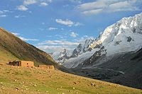
Upstream River Chitral, the long and beautiful inhabited Yarkhun valley
is bordered to the south by the Hindu Raj range. This range, with the
mountains of Gilgit and Swat & Hindu Kush East.
Many peaks are still virgin, many have unnames, all are technically
difficult, expeditions are rare. The glaciers are held for miles like
rivers of stones, go up and down can seem endless. In 1990, only 12
peaks over 6,000 meters had been climbed about thirty in all. In 2001
a French expedition succeeded several of them.
The Hindu Raj is an excellent area for expeditions wishing
first ascents, exploration small peaks in alpine style. Have to find a
time slightly more stable than in the regions of the Karakoram located
further west.
|
Boroghil pass
|
 The
project to connect Afghanistan by road by this wild pass is under study.
This road would make it possible to connect Afghanistan and especially
Tadjikistan, an alternate road, direct and pacified compared to the existing
ways. This project constitutes already a threat of pollutions for the
wild area of Hindu Raj. The
project to connect Afghanistan by road by this wild pass is under study.
This road would make it possible to connect Afghanistan and especially
Tadjikistan, an alternate road, direct and pacified compared to the existing
ways. This project constitutes already a threat of pollutions for the
wild area of Hindu Raj.
|
Karambar lake & valley
|
 The
Karambar Valley lies close to the Afghan border near the Boroghil Pass
and can be reached from the west (Chitral) via the Yarkhun Valley and
Lasht (the way the 1997 expedition entered), or from the east (Gilgit)
via the KKH to Sost (the way they left). The
Karambar Valley lies close to the Afghan border near the Boroghil Pass
and can be reached from the west (Chitral) via the Yarkhun Valley and
Lasht (the way the 1997 expedition entered), or from the east (Gilgit)
via the KKH to Sost (the way they left).
|
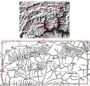
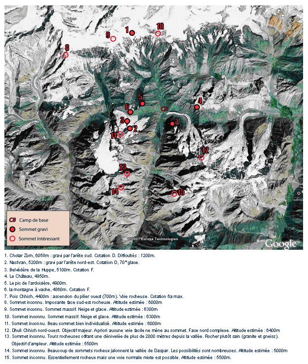
Daspar valley
|
The map below offers a summary of the tops climbed and
observed during summer 2007 by Florian....
|
Nialti valley, Ghalsapar glacier
|
The Fourth UIAA International Camp took place during September
2000 in the region north of Nialthi and west of the Thui Gol. Organized
by the FFME and under the overall leadership of the young French guide,
Manu Pellissier, the Camp was attended by 21 young climbers representing
Canada, the Czech Republic, Denmark, France, Germany, Great Britain, Hungary,
Ireland, Italy, Pakistan, Poland, Slovenia, South Africa and New Zealand.
|
Ishkoman valley
|
 Fifty
seven years old Angelo Rusconi, the noted Bregaglia-Masino activist from
the '60s and '70s, took a five-man Italian team into this relatively little
known valley, which forms the continuation of the Karambar River and runs
south from Imit to meet the Gigit River at Gakuch. Above this valley,
which forms the dividing line between the West Karakoram and the Hindu
Raj, the Italians discovered a wealth of isolated peaks from 4,000m-6,500m
in height. Operating from a lake shore Base Camp at 3,800m, the team made
the first ascent of an unnamed 5,100m peak on the 5th August, climbing
the east flank and encountering rock difficulties of IV and V. Fifty
seven years old Angelo Rusconi, the noted Bregaglia-Masino activist from
the '60s and '70s, took a five-man Italian team into this relatively little
known valley, which forms the continuation of the Karambar River and runs
south from Imit to meet the Gigit River at Gakuch. Above this valley,
which forms the dividing line between the West Karakoram and the Hindu
Raj, the Italians discovered a wealth of isolated peaks from 4,000m-6,500m
in height. Operating from a lake shore Base Camp at 3,800m, the team made
the first ascent of an unnamed 5,100m peak on the 5th August, climbing
the east flank and encountering rock difficulties of IV and V.
|
|
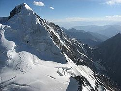
Ana Sar -5630m-
|
At the same time an Italian expedition under the leadership
of Franco Brunello was operating in the region, largely climbing and mapping
in the Chiantar Valley. The expedition climbed several routes, notably
the first ascent of the South West Face of Pt 6,189m, a 1,400m line with
sections up to 70ø, which was achieved in just six hours by Tarcisio
Bello. The peak overlooks the Suj Glacier north of Mathantir
|
Amman Chhish -4850m-
|
The following day, Ashworth teamed up with Christian Staunton
from Ireland to climb a short AD route (45°) up a minor peak above
the high camp on the upper glacier. Amman Chish (4,850m) was named after
the expedition's local guide, Ammanullah Khan.
|
Booni zom -6551m-
|
 [To
complete ] [To
complete ]
|
Chiantar Group -6000/6416m-
|
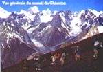 At
the same time an Italian expedition under the leadership of Franco Brunello
was operating in the region, largely climbing and mapping in the Chiantar
Valley. The expedition climbed several routes, notably the first ascent
of the South West Face of Pt 6,189m, a 1,400m line with sections up to
70ø, which was achieved in just six hours by Tarcisio Bello. The
peak overlooks the Suj Glacier north of Mathantir At
the same time an Italian expedition under the leadership of Franco Brunello
was operating in the region, largely climbing and mapping in the Chiantar
Valley. The expedition climbed several routes, notably the first ascent
of the South West Face of Pt 6,189m, a 1,400m line with sections up to
70ø, which was achieved in just six hours by Tarcisio Bello. The
peak overlooks the Suj Glacier north of Mathantir
|
Koh-i-Chiantar -6416m-
|
 This
summit is the biggest of the group, no information available yet. This
summit is the biggest of the group, no information available yet.
|
Karka -6222m-
|
 [To
complete] [To
complete]
|
Pt -6189m-
|
At the same time an Italian expedition under the leadership
of Franco Brunello was operating in the region, largely climbing and mapping
in the Chiantar Valley. The expedition climbed several routes, notably
the first ascent of the South West Face of Pt 6,189m, a 1,400m line with
sections up to 70ø, which was achieved in just six hours by Tarcisio
Bello. The peak overlooks the Suj Glacier north of Mathantir
|
Chikar Zom (Chikari) -6110m/5928m-
|
 The
Fourth UIAA International Camp took place during September in the region
north of Nialthi and west of the Thui Gol. Organized by the FFME and under
the overall leadership of the young French guide, Manu Pellissier, the
Camp was attended by 21 young climbers representing Canada, the Czech
Republic, Denmark, France, Germany, Great Britain, Hungary, Ireland, Italy,
Pakistan, Poland, Slovenia, South Africa and New Zealand. The
Fourth UIAA International Camp took place during September in the region
north of Nialthi and west of the Thui Gol. Organized by the FFME and under
the overall leadership of the young French guide, Manu Pellissier, the
Camp was attended by 21 young climbers representing Canada, the Czech
Republic, Denmark, France, Germany, Great Britain, Hungary, Ireland, Italy,
Pakistan, Poland, Slovenia, South Africa and New Zealand.
One of the major summits in the valley to gain a first ascent was the
impressive Chikari (5,928m). Early in the trip various members of the
expedition had pioneered a route through the Icefall to the upper Ghalsapar
Glacier. From a high camp at c4,870m the four Slovenians, Jernej Bevjk,
Jernej Brescak, Matej Kovacic and Matevz Kramer, climbed an east-facing
couloir, later christened the Coup de Sabre, to a col at 5,350m between
the long North Ridge of Chikari and the 5,620m Chikari Beag. Bevjk, Brescak,
and Kovacic returned later in the month to repeat this 400m couloir (rated
Alpine D), then follow the right flank of Chikari's North Ridge to camp
on a large snowfield. Next day, the 23rd September, they climbed the icy
600m slopes of the North West Face (up to 65°) to gain the summit
ridge, where they made an easy traverse to the top. The three Slovenians
were closely followed the same day by Gregory Coubat from France, Mathieu
Peloquin from Canada and Richard Wesley from New Zealand.
After their stay in the Arandu Valley reported above, the seven-member
Korean team appear to have visited the Ghalsapar Glacier north of Nialthi,
the same area explored by members of the 1999 UIAA International Camp.
Base Camp was set up at c3,750m from where members of the Korean team
report making two first ascents; the North East Face of Chikari (5,928m)
and the North East Face of Mustum (5,620m). Chikari, one of the dominant
summits of the valley, gained its first ascent in September 1999 curtesy
of the young Slovenians, Jernej Bevjk, Jernej Brescak and Matej Kovacic.
These three climbed an east-facing couloir, christened the Coup de Sabre
(400m; Alpine D), to the start of the long North Ridge, followed the latter
until they could traverse on to the 600m North West Face and climbed this
(60-65°) to the summit ridge, where they made an easy traverse to
the top. They were followed later the same day by three other climbers.
However, prior to this ascent the three Slovenians had climbed the obvious
but dangerous Central Couloir on the East Face (1,400m: TD) to gain the
North Ridge well right of the summit. They had hoped to slant left from
this couloir up the North East Face but found it too difficult after being
forced to make a bivouac in the couloir with no gear. It is assumed the
Koreans must have climbed a line on this impressive steep mixed face face
left of the couloir as they report climbing 1,750m with an overall grade
of V and technical difficulties up to M4 and WI4. On Mustum, the location
of which is uncertain, they again report an overall grade of V but found
technical difficulties of 5.9, M5 and WI4. The Korean leader, Seo, made
two attempts on Ultar in 1996 and climbed Gasherbrum II in 1997.
The Slovenian ascent of Chikari followed a previous attempt to climb directly
up the East Face. On the 16th-17th Bevjk, Brescak and Kovacic climbed
the most obvious line on the face, the large central couloir. This was
a bold and quite dangerous undertaking, requiring an exposed ascent of
the initial serac barrier. The three planned to leave the couloir at two-thirds
height and slant left to the summit via a prominent series of ice smears.
However, they found this too difficult and after a cold bivouac with little
equipment near the top of the couloir, continued to its exit on to the
North Ridge. At this point they decided to retreat without visiting the
summit. The 1,400m line was graded TD.
Several other parties attempted to reach the summit of Chikari by different
lines. The Czechs, Vojta Dvorak and Radek Lienerth, spent three days fixing
rope on a steep pillar of compact rock (which they refer to as the Chikari
Tower) rising out of the lower Ghalsapar Glacier at c4,000m. The climbing
was hard with difficulties up to F7a. After a rest at Base Camp, the two
returned, hauled gear to their high point, then followed easy mixed ground
on the left side of the East Face to reach a 4,800m col between the main
summit and Pt 5,250m, where they bivouacked. The next day, the 19th, they
attempted to climb the South East Ridge of Chikari but soon turned back
at c5,400m due to their slow progress on diabolical rock.
Three other small summits were reached. On the 12th Coubat and Peloquin
climbed Pt 4,980m via the North East Couloir (christened the Couloir du
Grand Pere) and East Ridge (1,000m: AD-). Jute Chish (4,300m) was climbed
by Drouillat and the French guide, Claude Gardien, on the 22nd via the
South Ridge (D: F5c). On the same day Nanar Peak (c4,400m) was climbed
by the Pakistan representative Jared Ali, Olivier Mansiot from France,
and Kiss and Pellissier (400m: TD-: F5c). Later, on the 25th, Drouillat
and Mansiot attempted the North West Ridge of Pt 4,980m but only reached
the top of the first gendarme at c4,380m after a 350m rock climb of F5c
and A0.


|
Chikari Beag -5620m
|
The Fourth UIAA International Camp took place during September
in the region north of Nialthi and west of the Thui Gol. Organized by
the FFME and under the overall leadership of the young French guide, Manu
Pellissier, the Camp was attended by 21 young climbers representing Canada,
the Czech Republic, Denmark, France, Germany, Great Britain, Hungary,
Ireland, Italy, Pakistan, Poland, Slovenia, South Africa and New Zealand.
Prior to this, the Coup de Sabre had been soloed by Rob Jarvis from the
UK in an abortive attempt on Chikari Beag. He eventually succeeded on
his third attempt with the other UK representative, Stephen Ashworth,
reaching the summit on the 21st via the 300m high South Ridge above the
col. The rock was generally poor and the difficulties around British Severe
with one short but well-protected section of British 4c. A slightly higher
North Summit was not visited due to the complexities of a nasty, loose
connecting ridge.
|
Chotar Zom -6058m
|
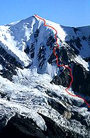 Chotar
Zom, c6,058m, climbed by the south ridge in 2007 (cotation D/1200m). (cf.
pictures nb 5 et 6) Chotar
Zom, c6,058m, climbed by the south ridge in 2007 (cotation D/1200m). (cf.
pictures nb 5 et 6)
|
Chota Pahad Sar -5660m-
|
The Fourth UIAA International Camp took place during September
2000 in the region north of Nialthi and west of the Thui Gol. Organized
by the FFME and under the overall leadership of the young French guide,
Manu Pellissier, the Camp was attended by 21 young climbers representing
Canada, the Czech Republic, Denmark, France, Germany, Great Britain, Hungary,
Ireland, Italy, Pakistan, Poland, Slovenia, South Africa and New Zealand.
Summit Chota Pahad Sar (c5,660m) by the South face in 1997.
|
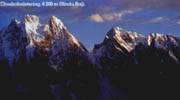
Chushubalstering group -5415/6158m-
|
The summit of Chushubalstering has attracted and then subsequently
deterred a number of expeditions (including several from the UK) since
it was first inspected in 1967 by a Japanese party. It would appear that
there is no direct line to the main top that is not seriously threatened
by serac fall or other objective dangers.
This very impressive 6,158m peak was the scene of two new routes, though
neither managed to reach the still virgin summit.
Chushubalstering -c6,158m-, Western
summit -~6000m- :
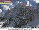 Even
more impressive, perhaps one of the most impressive technical routes achieved
in Pakistan during the year, was the near miss on the main summit by Stéphane
Benoist, Bruno Ravanat and Jérôme Thinières. These
three completed a fine new route to the top of the previously virgin West
Summit (c6,000m) but after four days on the mountain, tired and with little
food remaining, they elected to forego the final snow slopes to the Main
Top. Their route followed a thin and tenuous line more or less in the
centre of the 1,500m North North West Face face directly below the West
Summit. On the first day the three French climbed difficult ice, which
was exposed to stonefall, to a bivouac site at c5,000m below the main
rocky section of the wall. This in turn led to a comfortable ledge and
second bivouac at 5,400m. The third day began with a committing pendulum,
followed by increasingly difficult ice. The crux proved to be a wall of
snow and ice, 40m high with sections of 90-95° and no possibility
of protection (grade 6). The third bivouac was made at 5,800m close to
the top seracs. Even
more impressive, perhaps one of the most impressive technical routes achieved
in Pakistan during the year, was the near miss on the main summit by Stéphane
Benoist, Bruno Ravanat and Jérôme Thinières. These
three completed a fine new route to the top of the previously virgin West
Summit (c6,000m) but after four days on the mountain, tired and with little
food remaining, they elected to forego the final snow slopes to the Main
Top. Their route followed a thin and tenuous line more or less in the
centre of the 1,500m North North West Face face directly below the West
Summit. On the first day the three French climbed difficult ice, which
was exposed to stonefall, to a bivouac site at c5,000m below the main
rocky section of the wall. This in turn led to a comfortable ledge and
second bivouac at 5,400m. The third day began with a committing pendulum,
followed by increasingly difficult ice. The crux proved to be a wall of
snow and ice, 40m high with sections of 90-95° and no possibility
of protection (grade 6). The third bivouac was made at 5,800m close to
the top seracs.
Late on the fourth day the trio began their descent, following in part
a line to the right of their route that had been attempted a little earlier
in the expedition by Sylvain Empereur, Emmanuel Guy and Benoît Jacquemot.
Continuing through the night, Benoist, Ravanat and Thinières eventually
reached the glacier after 14 hours and 30 rappels, principally from Abalakov
Threads. Christened Yakamoneye and graded VII/6, M5, F6a, the route was
completed from the 19th-22nd August with Base Camp regained on the 23rd.
|
Chushubalstering, Northern summit (Denis
Peak) -c5,575m- :
 In
2000, on this virgin 5,700m summit between Chushubalstering (c6,158m)
and the Thui An (the pass at the head of the Aghost Bar Glacier), Marcel
Dumas, Erwan le Lann and Brice Lefèvre climbed a 36- pitch route
to the summit of a 5,575m top (christened Pic Denis) a little to the north
of the main peak. The route took four days to complete and followed a
steep but well- hidden 1,200m-high ice and mixed line alongside a spur
on the North Face. Difficulties were reported as 90-95° ice in the
initial section, followed by rock, mixed and more ice climbing up to F5+,
A1 and 75°. The trio took food for two days but carried no sleeping
bags. However, they did have a small bivouac tent with which to keep out
the elements. On the descent the climbers were forced to cut lengths of
rope for rappel anchors and by the time they had reached the glacier their
two 60m climbing ropes were reduced to 45m each. In
2000, on this virgin 5,700m summit between Chushubalstering (c6,158m)
and the Thui An (the pass at the head of the Aghost Bar Glacier), Marcel
Dumas, Erwan le Lann and Brice Lefèvre climbed a 36- pitch route
to the summit of a 5,575m top (christened Pic Denis) a little to the north
of the main peak. The route took four days to complete and followed a
steep but well- hidden 1,200m-high ice and mixed line alongside a spur
on the North Face. Difficulties were reported as 90-95° ice in the
initial section, followed by rock, mixed and more ice climbing up to F5+,
A1 and 75°. The trio took food for two days but carried no sleeping
bags. However, they did have a small bivouac tent with which to keep out
the elements. On the descent the climbers were forced to cut lengths of
rope for rappel anchors and by the time they had reached the glacier their
two 60m climbing ropes were reduced to 45m each.
|
Chushubalstering -c6,158m-, Eastern
summit -c5,415m- :
Summit climbed the 14th september 1999 by Christophe Argo
(Canada) and Richard Wesley (New Zeland), and in the day by Ildi Kiss
(Hungary) Emmanuel Pellissier, Benoit Drouillat (France) and Asmus Norreslet
(Danmark).
|